


3,8 km | 4,1 km-effort
Saalekreis : Entdecken Sie die besten Touren : 21 zu Fuß. Alle diese Touren, Trails, Routen und Outdoor-Aktivitäten sind in unseren SityTrail-Apps für Smartphones und Tablets verfügbar.
Zu Fuß


• Website: https://www.leuna.de/de/radwanderweg.html
Zu Fuß
• Trail created by Naturpark Saale-Unstrut-Triasland. In Planung
Zu Fuß
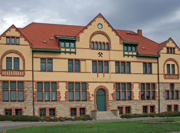
• Trail created by IG-Waldheit Lieskau. Symbol: Schwarze gekreuzte Hämmer auf weissem Rechteck Website: http://www.i...
Zu Fuß
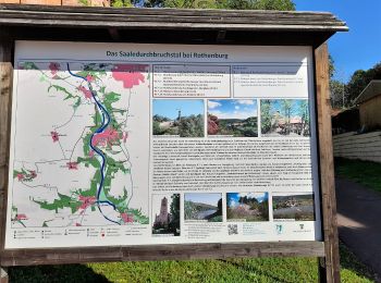
• Trail created by Naturpark Saale-Unstrut-Triasland.
Zu Fuß
• Symbol: grüner Schrägstrich auf weißem Grund
Zu Fuß
• Symbol: gelber Balken auf weißem Grund
Zu Fuß
• Trail created by Naturpark Saale-Unstrut-Triasland.
Zu Fuß
Zu Fuß
Zu Fuß
Zu Fuß
Zu Fuß

Zu Fuß
Zu Fuß
Zu Fuß
Zu Fuß
Zu Fuß
Zu Fuß
Zu Fuß
Zu Fuß
20 Angezeigte Touren bei 21
Kostenlosegpshiking-Anwendung
 SityTrail
IGN / Geografische Institute
SityTrail World
Die Welt öffnet sich für Sie