Trail Walking Hérin - circuit des cerises entre Hérin et La Sentinelle - Photo

circuit des cerises entre Hérin et La Sentinelle

 papiou
papiou

User

© OpenStreetMap contributors
Length
Length
8.4 km
Max alt
Max alt
62 m
Uphill gradient
Uphill gradient
40 m
Km-Effort
Km-Effort  
8.9 km
Min alt
Min alt
41 m
Downhill gradient
Downhill gradient
41 m
Boucle
Boucle
Yes
Creation date :
2016-06-30 00:00:00.0
Updated on :
2016-06-30 00:00:00.0

(0 Reviews)

Walking
Walking
1h51
Difficulty : Very easy

Scan this QR Code to open this trail in the SityTrail application

FREE GPS app for hiking

Logo SityTrail SityTrail

IGN / Geographical institutes

Download SityTrail from the App Store Download SityTrail from Google Play

Logo SityTrail SityTrail World

The world is yours!

Download SityTrail from the App Store Download SityTrail from Google Play Download SityTrail on Huawei AppGallery

About

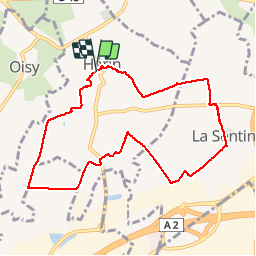
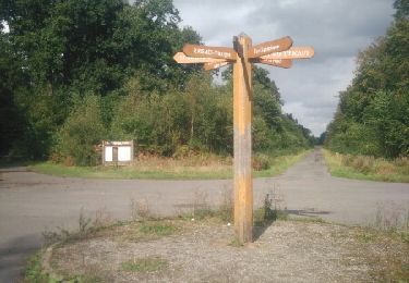
Trail Walking of 8.4 km to be discovered at Hauts-de-France, Nord, Hérin. This trail is proposed by papiou.

Description

RDV parking salle d'attente fêtes.prendre ruelle Bernard pour se rendre voie de tram puis au PN traverser la voie et prendre tout droit sentier des gremonts et rejoindre cité des 80 par la gauche
par la gauche. Aller cité des mines. la traverser et par la droite prendre chemin d'hurtebise puis à gauche rue de l'égalité à La Sentinelle. rejoindre la voie de tram par rues Lafarge, du 4 septembre, à l'arrêt de tram suivre jusqu'à Hérin et revenir par sentier de la montagne et impasse Ferrer.

Elevation profile

Positioning

Country:
France
Region :
Hauts-de-France
Department/Province :
Nord
Municipality :
Hérin
Location:
Unknown
Start:(UTM)
532141 ; 5578389 (31U) N.

Trails nearby

Trail Walking Raismes - Circuit du Terril de Sabatier - Photo
Walking
corsinou

Walking

Easy
(1)
Raismes, Hauts-de-France, Nord, France
13 km | 14.9 km-effort
2h 34min
Yes
Trail Mountain bike Wavrechain-sous-Denain - Direction Le Quesnoy - Denain - Photo
Mountain bike
tracegps

Mountain bike

Medium
(1)
Wavrechain-sous-Denain, Hauts-de-France, Nord, France
63 km | 70 km-effort
3h 0min
Yes
Trail Walking Raismes - variante de la course des terrils - Photo
Walking
papiou

Walking

Medium
(1)
Raismes, Hauts-de-France, Nord, France
8.8 km | 10 km-effort
2h 10min
Yes
Trail Walking Wallers - Mare goraux - Photo
Walking
xcreator

Walking

Medium
Wallers, Hauts-de-France, Nord, France
6.8 km | 7.5 km-effort
1h 32min
Yes
Trail Walking Haveluy - les pavés Bernard Hinault et pont femme à barbe  - Photo
Walking
papiou

Walking

Easy
Haveluy, Hauts-de-France, Nord, France
9.4 km | 10.1 km-effort
2h 0min
Yes
Trail Walking Wallers - forêt de Raismes et mare à Gorriaux - Photo
Walking
Templeuveenmarche

Walking

Medium
(2)
Wallers, Hauts-de-France, Nord, France
10.6 km | 11.7 km-effort
2h 35min
Yes
Trail Walking Raismes - Raismes, autours des terrils - Photo
Walking
papiou

Walking

Easy
Raismes, Hauts-de-France, Nord, France
8.9 km | 9.9 km-effort
1h 55min
Yes
Trail Walking Hérin - Hérin, variante des 4 clochers - Photo
Walking
papiou

Walking

Easy
Hérin, Hauts-de-France, Nord, France
8.7 km | 9.2 km-effort
1h 58min
Yes
Trail Walking Raismes - Circuit de la Mare à Goriaux - Photo
Walking
corsinou

Walking

Easy
Raismes, Hauts-de-France, Nord, France
8.5 km | 9.6 km-effort
2h 9min
Yes


Close
My subscriptions