Trail Mountain bike Wavrechain-sous-Denain - Direction Le Quesnoy - Denain - Photo

Direction Le Quesnoy - Denain

 tracegps
tracegps

User

© OpenStreetMap contributors
Length
Length
63 km
Max alt
Max alt
121 m
Uphill gradient
Uphill gradient
547 m
Km-Effort
Km-Effort  
70 km
Min alt
Min alt
19 m
Downhill gradient
Downhill gradient
546 m
Boucle
Boucle
Yes
Creation date :
2014-12-10 00:00:00.0
Updated on :
2014-12-10 00:00:00.0

(1 Reviews)

Mountain bike
Mountain bike
3h00
Difficulty : Medium

Scan this QR Code to open this trail in the SityTrail application

FREE GPS app for hiking

Logo SityTrail SityTrail

IGN / Geographical institutes

Download SityTrail from the App Store Download SityTrail from Google Play

Logo SityTrail SityTrail World

The world is yours!

Download SityTrail from the App Store Download SityTrail from Google Play Download SityTrail on Huawei AppGallery

About

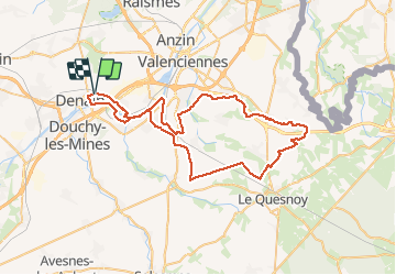
Trail Mountain bike of 63 km to be discovered at Hauts-de-France, Nord, Wavrechain-sous-Denain. This trail is proposed by tracegps.

Description

Simple roulant, un peu de D , c'est sympa on passe par Maing, Le Quesnoy, Wargnie, Jenlain...

Elevation profile

Positioning

Country:
France
Region :
Hauts-de-France
Department/Province :
Nord
Municipality :
Wavrechain-sous-Denain
Location:
Unknown
Start:(UTM)
529426 ; 5575504 (31U) N.

Comments

Please log in to post a review or rate the element


sympa


Trails nearby

Trail Walking Haveluy - les pavés Bernard Hinault et pont femme à barbe  - Photo
Walking
papiou

Walking

Easy
Haveluy, Hauts-de-France, Nord, France
9.4 km | 10.1 km-effort
2h 0min
Yes
Trail Walking Hérin - Hérin, variante des 4 clochers - Photo
Walking
papiou

Walking

Easy
Hérin, Hauts-de-France, Nord, France
8.7 km | 9.2 km-effort
1h 58min
Yes
Trail Mountain bike Wavrechain-sous-Denain - Entre les canaux de la Scarpe et l'Escaut - Wavrechain-sous-Denain  - Photo
Mountain bike
tracegps

Mountain bike

Medium
Wavrechain-sous-Denain, Hauts-de-France, Nord, France
53 km | 57 km-effort
2h 30min
Yes
Trail Mountain bike Bellaing - Circuit de la Folle Emprise - Bellaing       - Photo
Mountain bike
tracegps

Mountain bike

Medium
Bellaing, Hauts-de-France, Nord, France
11.3 km | 12.1 km-effort
1h 0min
Yes
Trail Walking Bellaing - Circuit de la Folle Emprise - Bellaing       - Photo
Walking
tracegps

Walking

Medium
(1)
Bellaing, Hauts-de-France, Nord, France
11.3 km | 12.1 km-effort
2h 49min
Yes
Trail Walking Escaudain - Circuit des anciennes Carrières et du vieil Escaudain - Escaudain  - Photo
Walking
tracegps

Walking

Medium
(1)
Escaudain, Hauts-de-France, Nord, France
9.9 km | 10.6 km-effort
2h 30min
Yes
Trail Walking Maing - Maing-circuit pas de boeuf, version 11km - Photo
Walking
papiou

Walking

Medium
Maing, Hauts-de-France, Nord, France
11.2 km | 12.5 km-effort
2h 32min
Yes
Trail Walking Aubry-du-Hainaut - boucle 7 numerisee - Photo
Walking
dehemjacques

Walking

Very easy
Aubry-du-Hainaut, Hauts-de-France, Nord, France
13.7 km | 14.8 km-effort
4h 21min
No
Trail Mountain bike Wavrechain-sous-Denain - Sortie VTT Porte du Hainaut - Wavrechain sous Denain - Photo
Mountain bike
tracegps

Mountain bike

Easy
Wavrechain-sous-Denain, Hauts-de-France, Nord, France
54 km | 58 km-effort
2h 30min
Yes


Close
My subscriptions