Trail Quad Clavé - rando soudan - Photo
 Didou 79
Didou 79

User

© OpenStreetMap contributors
Length
Length
49 km
Max alt
Max alt
191 m
Uphill gradient
Uphill gradient
422 m
Km-Effort
Km-Effort  
55 km
Min alt
Min alt
71 m
Downhill gradient
Downhill gradient
474 m
Boucle
Boucle
No
Creation date :
2024-03-02 07:15:40.452
Updated on :
2024-03-02 15:20:07.687

(1 Reviews)

Quad
Quad
2h52
Difficulty : Very easy

Scan this QR Code to open this trail in the SityTrail application

FREE GPS app for hiking

Logo SityTrail SityTrail

IGN / Geographical institutes

Download SityTrail from the App Store Download SityTrail from Google Play

Logo SityTrail SityTrail World

The world is yours!

Download SityTrail from the App Store Download SityTrail from Google Play Download SityTrail on Huawei AppGallery

About

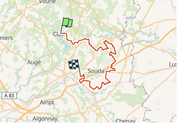
Trail Quad of 49 km to be discovered at New Aquitaine, Deux-Sèvres, Clavé. This trail is proposed by Didou 79.

Description

depart clavé arrivé Nanteuil

Elevation profile

Positioning

Country:
France
Region :
New Aquitaine
Department/Province :
Deux-Sèvres
Municipality :
Clavé
Location:
Unknown
Start:(UTM)
713842 ; 5152670 (30T) N.

Comments

Please log in to post a review or rate the element


Trails nearby

Trail Other activity Saint-Georges-de-Noisné - soleil levant  - Photo
Other activity
anonymous_fa1aecfc15

Other activity

Easy
Saint-Georges-de-Noisné, New Aquitaine, Deux-Sèvres, France
5 km | 5.6 km-effort
1h 23min
Yes
Trail Walking Clavé - CLAVE - Photo
Walking
dan79

Walking

Very easy
Clavé, New Aquitaine, Deux-Sèvres, France
6.2 km | 7.2 km-effort
1h 38min
Yes
Trail Quad Clavé - clavier didot 2022 - Photo
Quad
favraux

Quad

Very easy
Clavé, New Aquitaine, Deux-Sèvres, France
42 km | 51 km-effort
3h 13min
No
Trail Quad Clavé - randonnée du bocage  - Photo
Quad
favraux

Quad

Very easy
Clavé, New Aquitaine, Deux-Sèvres, France
603 m | 606 m-effort
3h 1min
No
Trail sport Saivres - SityTrail - la touche poupard - Photo
sport
createc

sport

Very easy
Saivres, New Aquitaine, Deux-Sèvres, France
30 km | 36 km-effort
Unknown
No
Trail Walking Saint-Georges-de-Noisné - 79 SAINT GEORGES DE NOISNE Les Vallons de Gâtine - Photo
Walking
maioy

Walking

Very easy
Saint-Georges-de-Noisné, New Aquitaine, Deux-Sèvres, France
13.3 km | 16.1 km-effort
3h 30min
Yes


Close
My subscriptions