Trail Walking Clavé - CLAVE - Photo
 dan79
dan79

User

© OpenStreetMap contributors
Length
Length
6.2 km
Max alt
Max alt
171 m
Uphill gradient
Uphill gradient
79 m
Km-Effort
Km-Effort  
7.2 km
Min alt
Min alt
128 m
Downhill gradient
Downhill gradient
80 m
Boucle
Boucle
Yes
Creation date :
2014-12-10 00:00:00.0
Updated on :
2014-12-10 00:00:00.0

(0 Reviews)

Walking
Walking
1h38
Difficulty : Unknown

Scan this QR Code to open this trail in the SityTrail application

FREE GPS app for hiking

Logo SityTrail SityTrail

IGN / Geographical institutes

Download SityTrail from the App Store Download SityTrail from Google Play

Logo SityTrail SityTrail World

The world is yours!

Download SityTrail from the App Store Download SityTrail from Google Play Download SityTrail on Huawei AppGallery

About

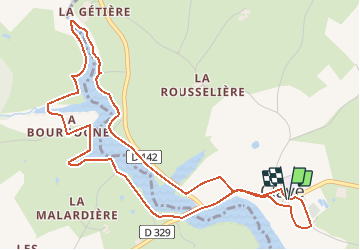
Trail Walking of 6.2 km to be discovered at New Aquitaine, Deux-Sèvres, Clavé. This trail is proposed by dan79.

Description

Départ randonnée : Village de Clavé (Deux-sèvres 79)
Petite randonnée autour d'un très agréable plan d'eau au cœur de la Gâtine Deux-Sévrienne.
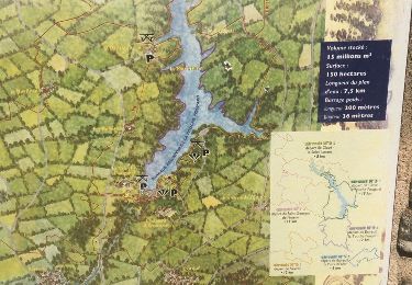
Ce plan d'eau artificiel provient du barrage de la Tourche-Poupard.
Bonne randonnée

Elevation profile

Positioning

Country:
France
Region :
New Aquitaine
Department/Province :
Deux-Sèvres
Municipality :
Clavé
Location:
Unknown
Start:(UTM)
713654 ; 5152582 (30T) N.

Trails nearby

Trail Other activity Saint-Georges-de-Noisné - soleil levant  - Photo
Other activity
anonymous_fa1aecfc15

Other activity

Easy
Saint-Georges-de-Noisné, New Aquitaine, Deux-Sèvres, France
5 km | 5.6 km-effort
1h 23min
Yes
Trail Quad Clavé - rando soudan - Photo
Quad
Didou 79

Quad

Very easy
(1)
Clavé, New Aquitaine, Deux-Sèvres, France
49 km | 55 km-effort
2h 52min
No
Trail Quad Clavé - clavier didot 2022 - Photo
Quad
favraux

Quad

Very easy
Clavé, New Aquitaine, Deux-Sèvres, France
42 km | 51 km-effort
3h 13min
No
Trail Quad Clavé - randonnée du bocage  - Photo
Quad
favraux

Quad

Very easy
Clavé, New Aquitaine, Deux-Sèvres, France
603 m | 606 m-effort
3h 1min
No
Trail sport Saivres - SityTrail - la touche poupard - Photo
sport
createc

sport

Very easy
Saivres, New Aquitaine, Deux-Sèvres, France
30 km | 36 km-effort
Unknown
No
Trail Walking Saint-Georges-de-Noisné - 79 SAINT GEORGES DE NOISNE Les Vallons de Gâtine - Photo
Walking
maioy

Walking

Very easy
Saint-Georges-de-Noisné, New Aquitaine, Deux-Sèvres, France
13.3 km | 16.1 km-effort
3h 30min
Yes


Close
My subscriptions