Trail Walking Melve - 20191126_Melve Tête de Boursier - Photo
© OpenStreetMap contributors
Length
Length
8.7 km
Max alt
Max alt
1418 m
Uphill gradient
Uphill gradient
577 m
Km-Effort
Km-Effort  
16.4 km
Min alt
Min alt
856 m
Downhill gradient
Downhill gradient
588 m
Boucle
Boucle
No
Creation date :
2019-11-26 08:30:44.692
Updated on :
2019-12-03 18:03:58.717

(1 Reviews)

Walking
Walking
5h05
Difficulty : Medium

Scan this QR Code to open this trail in the SityTrail application

FREE GPS app for hiking

Logo SityTrail SityTrail

IGN / Geographical institutes

Download SityTrail from the App Store Download SityTrail from Google Play

Logo SityTrail SityTrail World

The world is yours!

Download SityTrail from the App Store Download SityTrail from Google Play Download SityTrail on Huawei AppGallery

About

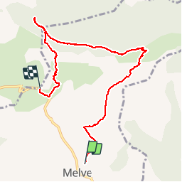
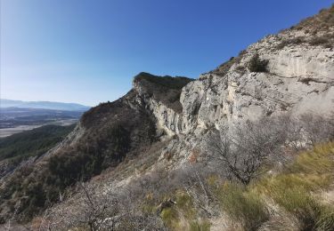
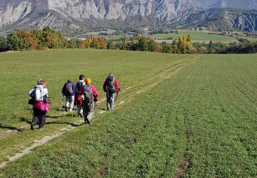
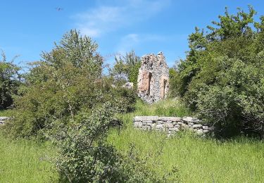
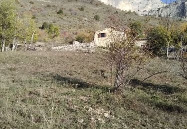
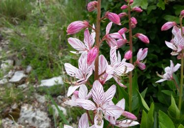
Trail Walking of 8.7 km to be discovered at Provence-Alpes-Côte d'Azur, Alpes-de-Haute-Provence, Melve. This trail is proposed by PapouBertrand.

Description

Randonnée Marche de 8,7 km et 580 mètres de dénivelé à découvrir à MELVE, ALPES-DE-HAUTE-PROVENCE.
Attention il faut deux voitures.

Elevation profile

Photos

Positioning

Country:
France
Region :
Provence-Alpes-Côte d'Azur
Department/Province :
Alpes-de-Haute-Provence
Municipality :
Melve
Location:
Unknown
Start:(UTM)
738544 ; 4915501 (31T) N.

Comments

Please log in to post a review or rate the element


Trails nearby

Trail Walking Monêtier-Allemont - le pic de Crigne - Photo
Walking
GUIDE
amiral13

Walking

Difficult
Monêtier-Allemont, Provence-Alpes-Côte d'Azur, Hautes-Alpes, France
5.6 km | 13.4 km-effort
3h 27min
Yes
Trail Walking Sigoyer - SIGOYER Boucle Croix de la Biousse o l m s - Photo
Walking
RobinMicheline

Walking

Medium
Sigoyer, Provence-Alpes-Côte d'Azur, Alpes-de-Haute-Provence, France
16.3 km | 23 km-effort
4h 25min
Yes
Trail Walking Monêtier-Allemont - SityTrail - Pic de Crigne. - Photo
Walking
Daniel.BRUN-PICARD

Walking

Medium
Monêtier-Allemont, Provence-Alpes-Côte d'Azur, Hautes-Alpes, France
4 km | 8.9 km-effort
2h 0min
Yes
Trail Walking Sigoyer - Sigoyer Les Baudes - Photo
Walking
claude nier

Walking

Easy
Sigoyer, Provence-Alpes-Côte d'Azur, Alpes-de-Haute-Provence, France
8.7 km | 12.3 km-effort
2h 42min
No
Trail Walking Claret - Tete de Boursier depart Claret - Photo
Walking
claude nier

Walking

Medium
Claret, Provence-Alpes-Côte d'Azur, Alpes-de-Haute-Provence, France
12 km | 22 km-effort
5h 32min
Yes
Trail Walking Sigoyer - Boucle Croix de la Biousse - Photo
Walking
claude nier

Walking

Medium
Sigoyer, Provence-Alpes-Côte d'Azur, Alpes-de-Haute-Provence, France
16.6 km | 23 km-effort
4h 57min
Yes
Trail Walking La Motte-du-Caire - LA MOTTE DU CAIRE .Le tour de la Blachere o - Photo
Walking
RobinMicheline

Walking

Difficult
La Motte-du-Caire, Provence-Alpes-Côte d'Azur, Alpes-de-Haute-Provence, France
37 km | 67 km-effort
4h 0min
No
Trail Walking Monêtier-Allemont - pic de Crigne - Photo
Walking
nadd73

Walking

Medium
Monêtier-Allemont, Provence-Alpes-Côte d'Azur, Hautes-Alpes, France
11.3 km | 23 km-effort
6h 23min
Yes
Trail Walking Melve - Melve Rando Pivoines, avec la RSPG : https://www.rspg05.org/ - Photo
Walking
Daniel.BRUN-PICARD

Walking

Medium
Melve, Provence-Alpes-Côte d'Azur, Alpes-de-Haute-Provence, France
8.3 km | 16.4 km-effort
5h 13min
No


Close
My subscriptions