Trail Walking Aulnoy-lez-Valenciennes - La vallée de la Rhonelle - Aulnoy-lez-Valenciennes - Photo

La vallée de la Rhonelle - Aulnoy-lez-Valenciennes

 tracegps
tracegps

User

© OpenStreetMap contributors
Length
Length
9.9 km
Max alt
Max alt
73 m
Uphill gradient
Uphill gradient
85 m
Km-Effort
Km-Effort  
11 km
Min alt
Min alt
35 m
Downhill gradient
Downhill gradient
85 m
Boucle
Boucle
Yes
Creation date :
2014-12-10 00:00:00.0
Updated on :
2014-12-10 00:00:00.0

(0 Reviews)

Walking
Walking
2h30
Difficulty : Medium

Scan this QR Code to open this trail in the SityTrail application

FREE GPS app for hiking

Logo SityTrail SityTrail

IGN / Geographical institutes

Download SityTrail from the App Store Download SityTrail from Google Play

Logo SityTrail SityTrail World

The world is yours!

Download SityTrail from the App Store Download SityTrail from Google Play Download SityTrail on Huawei AppGallery

About

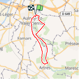
Trail Walking of 9.9 km to be discovered at Hauts-de-France, Nord, Aulnoy-lez-Valenciennes. This trail is proposed by tracegps.

Description

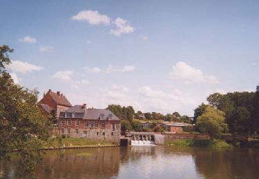
Circuit proposé par le comité départemental du Nord. Fiche n° 14 de la pochette «Échappées belles à travers le Nord». Rive gauche et rive droite de la Rhonelle offrent calme et observation de la nature à deux pas de la cité de Valenciennes. Aulnoy-lez-Valenciennes présente ainsi ses deux visages, rural et citadin. Possibilité de liaison avec Valenciennes par le tramway en empruntant le chemin piétonnier aménagé le long des voies. Départ de la station d’épuration, rue Victor Hugo à Aulnoy-lez-Valenciennes. Retrouvez cette randonnée sur le site du Comité Départemental du Tourisme du Nord.

Elevation profile

Photos

Positioning

Country:
France
Region :
Hauts-de-France
Department/Province :
Nord
Municipality :
Aulnoy-lez-Valenciennes
Location:
Unknown
Start:(UTM)
537824 ; 5575685 (31U) N.

Trails nearby

Trail Walking Estreux - Balade à Estreux  - Photo
Walking
tracegps

Walking

Medium
(1)
Estreux, Hauts-de-France, Nord, France
8.4 km | 9.4 km-effort
2h 10min
Yes
Trail Walking Curgies - curgies, circuit des blockhaus - Photo
Walking
papiou

Walking

Difficult
Curgies, Hauts-de-France, Nord, France
11.6 km | 13 km-effort
2h 45min
Yes
Trail Walking Quérénaing - la querenaingeoise trace faite - Photo
Walking
papiou

Walking

Very easy
Quérénaing, Hauts-de-France, Nord, France
9.1 km | 10.2 km-effort
1h 33min
Yes
Trail Mountain bike Maing - boucle autour de Maing - Photo
Mountain bike
Obeone2264

Mountain bike

Medium
Maing, Hauts-de-France, Nord, France
16.5 km | 18.1 km-effort
2h 0min
Yes
Trail Walking Maing - Maing-circuit pas de boeuf, version 11km - Photo
Walking
papiou

Walking

Medium
Maing, Hauts-de-France, Nord, France
11.2 km | 12.5 km-effort
2h 32min
Yes
Trail Cycle Valenciennes - Val'Roq 2015 - Photo
Cycle
guizite

Cycle

Difficult
Valenciennes, Hauts-de-France, Nord, France
885 km | 986 km-effort
55h 12min
No
Trail Walking Aubry-du-Hainaut - aubry. parcours du coeur - Photo
Walking
papiou

Walking

Medium
Aubry-du-Hainaut, Hauts-de-France, Nord, France
8.7 km | 9.3 km-effort
2h 9min
Yes
Trail Mountain bike Marly - zette - Photo
Mountain bike
jdaviere

Mountain bike

Very difficult
Marly, Hauts-de-France, Nord, France
40 km | 45 km-effort
2h 11min
Yes
Trail Walking Valenciennes - Valenciennes artistes - Photo
Walking
arpenteur59

Walking

Easy
Valenciennes, Hauts-de-France, Nord, France
8.7 km | 9.5 km-effort
2h 25min
Yes


Close
My subscriptions