Bouches-du-Rhône, Provence-Alpes-Côte d'Azur, On foot: Best trails, routes and walks

898 comments

Bouches-du-Rhône: Discover the best trails: 7875 walking, 282 running, 361 nordic walking, 94 trail and 345 on foot. All these trails, routes and outdoor activities are available in our SityTrail applications for smartphones and tablets.


The best trails (8918)

Trail Walking Roquefort-la-Bédoule - Grand Caunet, le Montounier - Photo
Walking 16.532
Km
GUIDE

Walking

Medium
(1)
Roquefort-la-Bédoule, Provence-Alpes-Côte d'Azur, Bouches-du-Rhône, France
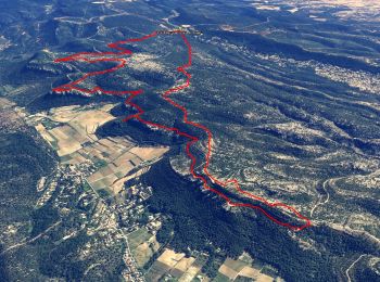
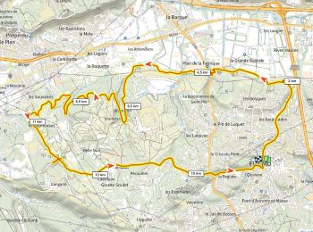
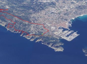
16.5 km | 24 km-effort
6h 0min
538 m
539 m
Yes
affinetataille

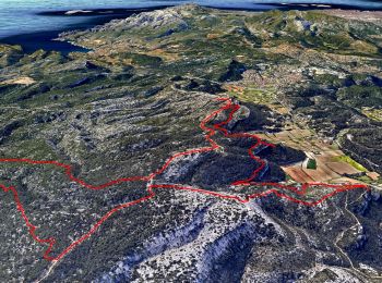
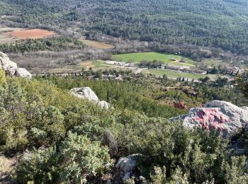
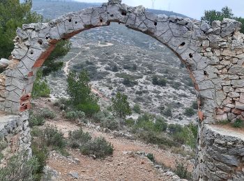
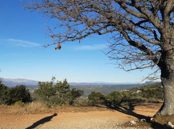
• Une jolie boucle qui vaut par les points de vue qui se succèdent tout son long. Du Mont Caume au Garlaban en passant ...

Trail Walking Aubagne - SityTrail - Le garlaban - Aubagne - Photo
Walking 14.22
Km
GUIDE

Walking

Difficult
(1)
Aubagne, Provence-Alpes-Côte d'Azur, Bouches-du-Rhône, France
14.2 km | 24 km-effort
7h 0min
708 m
710 m
Yes
affinetataille

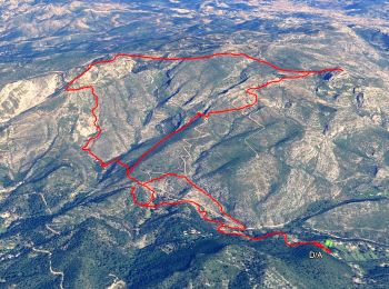
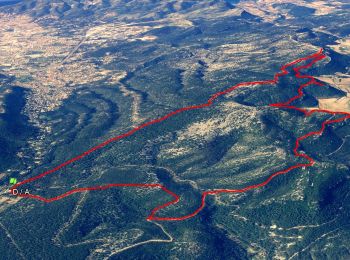
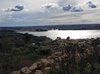
• Belle randonnée niveau N3S. Magnifiques points de vues tout au long du parcours. Passage par points de tournages des ...

Trail Walking Saint-Rémy-de-Provence - Alpilles  - Photo
Walking 19.157
Km
GUIDE

Walking

Difficult
(1)
Saint-Rémy-de-Provence, Provence-Alpes-Côte d'Azur, Bouches-du-Rhône, France
19.2 km | 27 km-effort
5h 7min
541 m
614 m
No
nadinebondoux

Trail Walking Marseille - Luminy: Le chemin du Centaure - Photo
Walking 8.62
Km
GUIDE

Walking

Easy
(1)
Marseille, Provence-Alpes-Côte d'Azur, Bouches-du-Rhône, France
8.6 km | 12.5 km-effort
2h 12min
288 m
288 m
Yes
lhomme.ph

Trail Walking Ceyreste - Autour du Montounier 2eme version - Photo
Walking 15.748
Km
GUIDE

Walking

Medium
(1)
Ceyreste, Provence-Alpes-Côte d'Azur, Bouches-du-Rhône, France
15.7 km | 24 km-effort
6h 0min
595 m
597 m
Yes
affinetataille

Trail Walking Roquefort-la-Bédoule - SityTrail - Grand Caunet, Cabanons, Vigie , Grotte Raymond, Ruines roquefort, Chapelle St andré - Photo
Walking 14.153
Km
GUIDE

Walking

Easy
(1)
Roquefort-la-Bédoule, Provence-Alpes-Côte d'Azur, Bouches-du-Rhône, France
14.2 km | 19.9 km-effort
6h 0min
432 m
433 m
Yes
affinetataille

• .

Trail Walking Cassis - SityTrail - Les 3 Calanques - Cassis - Photo
Walking 16.551
Km
GUIDE

Walking

Difficult
(1)
Cassis, Provence-Alpes-Côte d'Azur, Bouches-du-Rhône, France
16.6 km | 25 km-effort
6h 0min
603 m
602 m
Yes
affinetataille

Trail Walking Cassis - SityTrail - cassis la couronne - Photo
Walking 16.138
Km
GUIDE

Walking

Medium
(3)
Cassis, Provence-Alpes-Côte d'Azur, Bouches-du-Rhône, France
16.1 km | 24 km-effort
6h 0min
556 m
556 m
Yes
affinetataille

Trail Walking Fuveau - Canal par le chemin de fer - Photo
Walking 16.811
Km

Walking

Very difficult
(1)
Fuveau, Provence-Alpes-Côte d'Azur, Bouches-du-Rhône, France
16.8 km | 21 km-effort
4h 40min
279 m
281 m
Yes
ericberlin

Trail Walking Saint-Antonin-sur-Bayon - Ste Victoire - Le Garagaï - Photo
Walking 15.788
Km

Walking

Difficult
(1)
Saint-Antonin-sur-Bayon, Provence-Alpes-Côte d'Azur, Bouches-du-Rhône, France
15.8 km | 28 km-effort
4h 36min
889 m
890 m
Yes
ETMU5496

Trail Walking Aubagne - font de mai de Jean claude - Photo
Walking 8.776
Km

Walking

Difficult
(1)
Aubagne, Provence-Alpes-Côte d'Azur, Bouches-du-Rhône, France
8.8 km | 12.8 km-effort
2h 54min
300 m
300 m
Yes
Coryphene

Trail Walking Allauch - Le tour des Grands Ubacs au départ de Pichauris - Photo
Walking 13.26
Km

Walking

Easy
(1)
Allauch, Provence-Alpes-Côte d'Azur, Bouches-du-Rhône, France
13.3 km | 20 km-effort
4h 25min
517 m
516 m
Yes
Coqorico

Trail Walking La Ciotat - Rando Ciotat - Photo
Walking 12.125
Km
GUIDE

Walking

Difficult
(1)
La Ciotat, Provence-Alpes-Côte d'Azur, Bouches-du-Rhône, France
12.1 km | 19.9 km-effort
7h 30min
585 m
579 m
Yes
affinetataille

Trail Walking Miramas - Miramas le vieux- tour de guet - Photo
Walking 14.383
Km

Walking

Difficult
(1)
Miramas, Provence-Alpes-Côte d'Azur, Bouches-du-Rhône, France
14.4 km | 18 km-effort
3h 52min
269 m
269 m
Yes
Berpav

Trail On foot La Roque-d'Anthéron - Chemin aménagé le long de la DURANCE - Photo
On foot 13.959
Km

On foot

Very easy
(1)
La Roque-d'Anthéron, Provence-Alpes-Côte d'Azur, Bouches-du-Rhône, France
14 km | 14.9 km-effort
Unknown
69 m
83 m
No
dominique dubroca

Trail Walking Lançon-Provence - muet - Photo
Walking 9.877
Km

Walking

Medium
(1)
Lançon-Provence, Provence-Alpes-Côte d'Azur, Bouches-du-Rhône, France
9.9 km | 11.9 km-effort
2h 18min
151 m
148 m
Yes
Berpav

• marche

Trail Walking Gémenos - St Pons Le Fauge Glacière  - Photo
Walking 11.729
Km
GUIDE

Walking

Difficult
(1)
Gémenos, Provence-Alpes-Côte d'Azur, Bouches-du-Rhône, France
11.7 km | 18.6 km-effort
3h 56min
513 m
514 m
Yes
lhomme.ph

Trail Walking Simiane-Collongue - chemin de gui - Photo
Walking 5.929
Km

Walking

Easy
(1)
Simiane-Collongue, Provence-Alpes-Côte d'Azur, Bouches-du-Rhône, France
5.9 km | 8.1 km-effort
1h 45min
158 m
165 m
Yes
rvdebouc

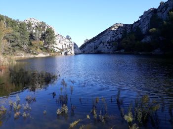
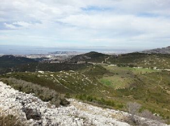
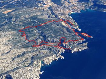
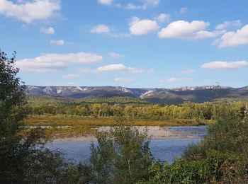
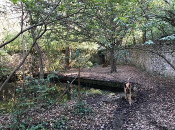
• balade sympa, partie nord ombragée, retour par le canyon (photo 3), photo 4 point d'eau permanent pour nos chiens

Trail Walking Fontvieille - du moulin de Daudet à l'aqueduc romain - Photo
Walking 14.242
Km

Walking

Medium
(2)
Fontvieille, Provence-Alpes-Côte d'Azur, Bouches-du-Rhône, France
14.2 km | 17.2 km-effort
3h 59min
219 m
220 m
Yes
hervef13300

• Départ et retour de font vieille

Trail Walking Éguilles - PF-Eguilles, balade dans les collines - Photo
Walking 13.086
Km

Walking

Easy
(1)
Éguilles, Provence-Alpes-Côte d'Azur, Bouches-du-Rhône, France
13.1 km | 16.1 km-effort
3h 29min
228 m
228 m
Yes
MicDul

• Départ : parking Espace Georges Duby

20 trails displayed on 8918

FREE GPS app for hiking

Logo SityTrail SityTrail

IGN / Geographical institutes

Download SityTrail from the App Store Download SityTrail from Google Play

Logo SityTrail SityTrail World

The world is yours!

Download SityTrail from the App Store Download SityTrail from Google Play Download SityTrail on Huawei AppGallery

Activities

Nearby regions

Close
My subscriptions