![](/images/other/stat-length.png)
![Tocht Stappen Crécy-la-Chapelle - Autour de Tigeaux - Photo](https://media.geolcdn.com/t/1900/400/ext.pjpeg?maxdim=2&url=https%3A%2F%2Fstatic1.geolcdn.com%2Fsiteimages%2Fupload%2Ffiles%2F1553511878bg_sport_marche.png)
Autour de Tigeaux
em77
Gebruiker
![Lengte](/images/other/stat-length.png)
Lengte
13,2 km
![Max. hoogte](https://static1.geolcdn.com/siteimages/upload/files/1508320355ic_sort_altitude_max_24dp.png)
Max. hoogte
133 m
![Positief hoogteverschil](https://static1.geolcdn.com/siteimages/upload/files/1508320355ic_sort_den_pos_24dp.png)
Positief hoogteverschil
251 m
![Km-Effort](/images/other/stat-length.png)
Km-Effort
16,5 km
![Min. hoogte](https://static1.geolcdn.com/siteimages/upload/files/1508320355ic_sort_altitude_min_24dp.png)
Min. hoogte
51 m
![Negatief hoogteverschil](https://static1.geolcdn.com/siteimages/upload/files/1508320355ic_sort_den_neg_24dp.png)
Negatief hoogteverschil
253 m
![Boucle](https://static1.geolcdn.com/siteimages/upload/files/16400158638029165_repeat_loop_refresh_sync_direction_icon.png)
Boucle
Ja
Datum van aanmaak :
2014-12-10 00:00:00.0
Laatste wijziging :
2014-12-10 00:00:00.0
![Stappen](https://static1.geolcdn.com/sitytour/trail-icons/101.png)
2h37
Moeilijkheid : Medium
![Scan deze QR-code om de tocht te openen in de SityTrail-applicatie](https://capi.geolives.com/qq0zvz2zws4bq2lad0pu/sitytour/trails/99822/qr.png?size=200)
Gratisgps-wandelapplicatie
Over ons
Tocht Stappen van 13,2 km beschikbaar op Île-de-France, Seine-et-Marne, Crécy-la-Chapelle. Deze tocht wordt voorgesteld door em77.
Beschrijving
Petite randonnée sympa autour de Tigeaux. Jolies vues des deux rives de la vallée du Morin. Le terrain peut être un peu gras.
Plaatsbepaling
Land:
France
Regio :
Île-de-France
Departement/Provincie :
Seine-et-Marne
Gemeente :
Crécy-la-Chapelle
Locatie:
Unknown
Vertrek:(Dec)
Vertrek:(UTM)
493645 ; 5409867 (31U) N.
Opmerkingen
Wandeltochten in de omgeving
![Tocht Stappen Crécy-la-Chapelle - Boucle 28 km autour de Crecy la Chapelle - Guérard - Voulangis - Tigeaux - Photo](https://media.geolcdn.com/t/375/260/ec792934-9951-48a4-9c10-6a048c9ff4d6.jpg&format=jpg&maxdim=2)
![Stappen Stappen](https://static1.geolcdn.com/sitytour/trail-icons/101.png)
Boucle 28 km autour de Crecy la Chapelle - Guérard - Voulangis - Tigeaux
Stappen
Medium
Crécy-la-Chapelle,
Île-de-France,
Seine-et-Marne,
France
![](/images/other/stat-length.png)
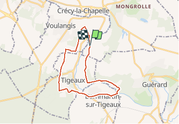
28 km | 35 km-effort
5h 46min
![](https://static1.geolcdn.com/siteimages/upload/files/16400158638029165_repeat_loop_refresh_sync_direction_icon.png)
Ja
![Tocht Stappen Crécy-la-Chapelle - Crécy la Chapelle Parcours normal - Photo](https://media.geolcdn.com/t/375/260/ext.jpg?maxdim=2&url=https%3A%2F%2Fstatic1.geolcdn.com%2Fsiteimages%2Fupload%2Ffiles%2F1553511878bg_sport_marche.png)
![Stappen Stappen](https://static1.geolcdn.com/sitytour/trail-icons/101.png)
Crécy la Chapelle Parcours normal
Stappen
Gemakkelijk
(1)
Crécy-la-Chapelle,
Île-de-France,
Seine-et-Marne,
France
![](/images/other/stat-length.png)
16,1 km | 19,5 km-effort
4h 18min
![](https://static1.geolcdn.com/siteimages/upload/files/16400158638029165_repeat_loop_refresh_sync_direction_icon.png)
Ja
![Tocht Stappen Crécy-la-Chapelle - Crécy la chapelle - Photo](https://media.geolcdn.com/t/375/260/ext.jpg?maxdim=2&url=https%3A%2F%2Fstatic1.geolcdn.com%2Fsiteimages%2Fupload%2Ffiles%2F1553511878bg_sport_marche.png)
![Stappen Stappen](https://static1.geolcdn.com/sitytour/trail-icons/101.png)
Crécy la chapelle
Stappen
Gemakkelijk
(2)
Crécy-la-Chapelle,
Île-de-France,
Seine-et-Marne,
France
![](/images/other/stat-length.png)
19,7 km | 24 km-effort
5h 12min
![](https://static1.geolcdn.com/siteimages/upload/files/16400158638029165_repeat_loop_refresh_sync_direction_icon.png)
Ja
![Tocht Stappen Crécy-la-Chapelle - Crécy la Chapelle - Photo](https://media.geolcdn.com/t/375/260/ext.jpg?maxdim=2&url=https%3A%2F%2Fstatic1.geolcdn.com%2Fsiteimages%2Fupload%2Ffiles%2F1553511878bg_sport_marche.png)
![Stappen Stappen](https://static1.geolcdn.com/sitytour/trail-icons/101.png)
Crécy la Chapelle
Stappen
Medium
(1)
Crécy-la-Chapelle,
Île-de-France,
Seine-et-Marne,
France
![](/images/other/stat-length.png)
16,4 km | 20 km-effort
4h 23min
![](https://static1.geolcdn.com/siteimages/upload/files/16400158638029165_repeat_loop_refresh_sync_direction_icon.png)
Ja
![Tocht Stappen Voulangis - Voulangis - Crécy - Villiers lqqm - Photo](https://media.geolcdn.com/t/375/260/ext.jpg?maxdim=2&url=https%3A%2F%2Fstatic1.geolcdn.com%2Fsiteimages%2Fupload%2Ffiles%2F1553511878bg_sport_marche.png)
![Stappen Stappen](https://static1.geolcdn.com/sitytour/trail-icons/101.png)
Voulangis - Crécy - Villiers lqqm
Stappen
Moeilijk
(1)
Voulangis,
Île-de-France,
Seine-et-Marne,
France
![](/images/other/stat-length.png)
12,9 km | 15,7 km-effort
3h 34min
![](https://static1.geolcdn.com/siteimages/upload/files/16400158638029165_repeat_loop_refresh_sync_direction_icon.png)
Ja
![Tocht Stappen Voulangis - Voulangis - Crécy - Villiers - Photo](https://media.geolcdn.com/t/375/260/ext.jpg?maxdim=2&url=https%3A%2F%2Fstatic1.geolcdn.com%2Fsiteimages%2Fupload%2Ffiles%2F1553511878bg_sport_marche.png)
![Stappen Stappen](https://static1.geolcdn.com/sitytour/trail-icons/101.png)
Voulangis - Crécy - Villiers
Stappen
Moeilijk
(1)
Voulangis,
Île-de-France,
Seine-et-Marne,
France
![](/images/other/stat-length.png)
12,9 km | 15,7 km-effort
3h 34min
![](https://static1.geolcdn.com/siteimages/upload/files/16400158638029165_repeat_loop_refresh_sync_direction_icon.png)
Ja
![Tocht Stappen Guérard - Guérard - Photo](https://media.geolcdn.com/t/375/260/604a5cf1-31c1-4e64-b7ed-ed1e6e2756f8.jpg&format=jpg&maxdim=2)
![Stappen Stappen](https://static1.geolcdn.com/sitytour/trail-icons/101.png)
Guérard
Stappen
Moeilijk
Guérard,
Île-de-France,
Seine-et-Marne,
France
![](/images/other/stat-length.png)
15,4 km | 18,5 km-effort
4h 3min
![](https://static1.geolcdn.com/siteimages/upload/files/16400158638029165_repeat_loop_refresh_sync_direction_icon.png)
Ja
![Tocht Stappen Tigeaux - Tigeaux - Photo](https://media.geolcdn.com/t/375/260/ext.jpg?maxdim=2&url=https%3A%2F%2Fstatic1.geolcdn.com%2Fsiteimages%2Fupload%2Ffiles%2F1553511878bg_sport_marche.png)
![Stappen Stappen](https://static1.geolcdn.com/sitytour/trail-icons/101.png)
Tigeaux
Stappen
Medium
(1)
Tigeaux,
Île-de-France,
Seine-et-Marne,
France
![](/images/other/stat-length.png)
19,1 km | 24 km-effort
5h 24min
![](https://static1.geolcdn.com/siteimages/upload/files/16400158638029165_repeat_loop_refresh_sync_direction_icon.png)
Ja
![Stappen Stappen](https://static1.geolcdn.com/sitytour/trail-icons/101.png)
Les coteaux du Grand Morin
Stappen
Medium
Crécy-la-Chapelle,
Île-de-France,
Seine-et-Marne,
France
![](/images/other/stat-length.png)
11,8 km | 14,3 km-effort
3h 6min
![](https://static1.geolcdn.com/siteimages/upload/files/16400158638029165_repeat_loop_refresh_sync_direction_icon.png)
Ja
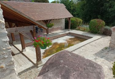
Belle randonnée pourtant proche de Paris.