![](/images/other/stat-length.png)
![Tocht Andere activiteiten Heuqueville - heuqueville - Photo](https://media.geolcdn.com/t/1900/400/ext.pjpeg?maxdim=2&url=https%3A%2F%2Fstatic1.geolcdn.com%2Fsiteimages%2Fupload%2Ffiles%2F1545311037marcheuse_200dpi.jpg)
heuqueville
rendebnad
Gebruiker
![Lengte](/images/other/stat-length.png)
Lengte
12,3 km
![Max. hoogte](https://static1.geolcdn.com/siteimages/upload/files/1508320355ic_sort_altitude_max_24dp.png)
Max. hoogte
144 m
![Positief hoogteverschil](https://static1.geolcdn.com/siteimages/upload/files/1508320355ic_sort_den_pos_24dp.png)
Positief hoogteverschil
258 m
![Km-Effort](/images/other/stat-length.png)
Km-Effort
15,7 km
![Min. hoogte](https://static1.geolcdn.com/siteimages/upload/files/1508320355ic_sort_altitude_min_24dp.png)
Min. hoogte
49 m
![Negatief hoogteverschil](https://static1.geolcdn.com/siteimages/upload/files/1508320355ic_sort_den_neg_24dp.png)
Negatief hoogteverschil
259 m
![Boucle](https://static1.geolcdn.com/siteimages/upload/files/16400158638029165_repeat_loop_refresh_sync_direction_icon.png)
Boucle
Ja
Datum van aanmaak :
2019-01-15 12:10:41.95
Laatste wijziging :
2019-01-15 12:10:41.95
![Andere activiteiten](https://static1.geolcdn.com/sitytour/trail-icons/900.png)
4h00
Moeilijkheid : Medium
![Scan deze QR-code om de tocht te openen in de SityTrail-applicatie](https://capi.geolives.com/qq0zvz2zws4bq2lad0pu/sitytour/trails/995013/qr.png?size=200)
Gratisgps-wandelapplicatie
Over ons
Tocht Andere activiteiten van 12,3 km beschikbaar op Normandië, Eure, Heuqueville. Deze tocht wordt voorgesteld door rendebnad.
Beschrijving
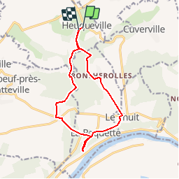
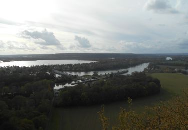
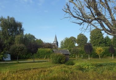
depart heuqueville,hameau de roncherolles, le Thuit,la Roquette, Fretteville,, Coix Chevalier bois de la couronne, heuqeville
Plaatsbepaling
Land:
France
Regio :
Normandië
Departement/Provincie :
Eure
Gemeente :
Heuqueville
Locatie:
Unknown
Vertrek:(Dec)
Vertrek:(UTM)
379239 ; 5460602 (31U) N.
Opmerkingen
Wandeltochten in de omgeving
![Tocht Stappen Les Andelys - Les Andelys - Le Thuit et ND de Bellegarde - Photo](https://media.geolcdn.com/t/375/260/ext.jpg?maxdim=2&url=https%3A%2F%2Fstatic1.geolcdn.com%2Fsiteimages%2Fupload%2Ffiles%2F1553511878bg_sport_marche.png)
![Stappen Stappen](https://static1.geolcdn.com/sitytour/trail-icons/101.png)
Les Andelys - Le Thuit et ND de Bellegarde
Stappen
Moeilijk
(1)
Les Andelys,
Normandië,
Eure,
France
![](/images/other/stat-length.png)
13,3 km | 16,2 km-effort
3h 40min
![](https://static1.geolcdn.com/siteimages/upload/files/16400158638029165_repeat_loop_refresh_sync_direction_icon.png)
Ja
![Tocht Stappen Les Andelys - Les Andelys - Le Thuit var 2 - Photo](https://media.geolcdn.com/t/375/260/ext.jpg?maxdim=2&url=https%3A%2F%2Fstatic1.geolcdn.com%2Fsiteimages%2Fupload%2Ffiles%2F1553511878bg_sport_marche.png)
![Stappen Stappen](https://static1.geolcdn.com/sitytour/trail-icons/101.png)
Les Andelys - Le Thuit var 2
Stappen
Gemakkelijk
(1)
Les Andelys,
Normandië,
Eure,
France
![](/images/other/stat-length.png)
8,3 km | 10,3 km-effort
2h 14min
![](https://static1.geolcdn.com/siteimages/upload/files/16400158638029165_repeat_loop_refresh_sync_direction_icon.png)
Ja
![Stappen Stappen](https://static1.geolcdn.com/sitytour/trail-icons/101.png)
20231024-Pont-St-Pierre
Stappen
Moeilijk
Pont-Saint-Pierre,
Normandië,
Eure,
France
![](/images/other/stat-length.png)
10,1 km | 13,3 km-effort
3h 20min
![](https://static1.geolcdn.com/siteimages/upload/files/16400158638029165_repeat_loop_refresh_sync_direction_icon.png)
Neen
![Stappen Stappen](https://static1.geolcdn.com/sitytour/trail-icons/101.png)
20230810-Heuqueville Jourrnée
Stappen
Moeilijk
Heuqueville,
Normandië,
Eure,
France
![](/images/other/stat-length.png)
20 km | 27 km-effort
5h 57min
![](https://static1.geolcdn.com/siteimages/upload/files/16400158638029165_repeat_loop_refresh_sync_direction_icon.png)
Ja
![Tocht Stappen Daubeuf-près-Vatteville - 20240528-daubeuf pres vatteville - Photo](https://media.geolcdn.com/t/375/260/adf15bba-069b-459e-ad33-06394c5e8d1f.jpg&format=jpg&maxdim=2)
![Stappen Stappen](https://static1.geolcdn.com/sitytour/trail-icons/101.png)
20240528-daubeuf pres vatteville
Stappen
Medium
Daubeuf-près-Vatteville,
Normandië,
Eure,
France
![](/images/other/stat-length.png)
11 km | 13,7 km-effort
3h 22min
![](https://static1.geolcdn.com/siteimages/upload/files/16400158638029165_repeat_loop_refresh_sync_direction_icon.png)
Ja
![Tocht Stappen Les Andelys - Les Andelys le Mont Pivin - Photo](https://media.geolcdn.com/t/375/260/2e30a977-82f2-4086-8b81-28620c9148e1.jpg&format=jpg&maxdim=2)
![Stappen Stappen](https://static1.geolcdn.com/sitytour/trail-icons/101.png)
Les Andelys le Mont Pivin
Stappen
Moeilijk
Les Andelys,
Normandië,
Eure,
France
![](/images/other/stat-length.png)
10,1 km | 14,4 km-effort
3h 16min
![](https://static1.geolcdn.com/siteimages/upload/files/16400158638029165_repeat_loop_refresh_sync_direction_icon.png)
Ja
![Tocht Stappen Le Thuit - 230602 Andelys A - Photo](https://media.geolcdn.com/t/375/260/13adf67b-3ef8-43a4-aa0b-ee1daaccfb66.jpg&format=jpg&maxdim=2)
![Stappen Stappen](https://static1.geolcdn.com/sitytour/trail-icons/101.png)
![Tocht Stappen Les Andelys - Les falaises de craies des Andelys - Photo](https://media.geolcdn.com/t/375/260/72f276d6-7736-49b8-9562-6a2084f395e8.jpg&format=jpg&maxdim=2)
![Stappen Stappen](https://static1.geolcdn.com/sitytour/trail-icons/101.png)
Les falaises de craies des Andelys
Stappen
Moeilijk
Les Andelys,
Normandië,
Eure,
France
![](/images/other/stat-length.png)
7,6 km | 11,3 km-effort
3h 21min
![](https://static1.geolcdn.com/siteimages/upload/files/16400158638029165_repeat_loop_refresh_sync_direction_icon.png)
Ja
![Tocht Stappen Les Andelys - les Andelys du 11/09/2022 - Photo](https://media.geolcdn.com/t/375/260/495db3c6-ba78-44de-95e7-48ab65377867.jpg&format=jpg&maxdim=2)
![Stappen Stappen](https://static1.geolcdn.com/sitytour/trail-icons/101.png)
les Andelys du 11/09/2022
Stappen
Zeer moeilijk
Les Andelys,
Normandië,
Eure,
France
![](/images/other/stat-length.png)
18,1 km | 22 km-effort
4h 17min
![](https://static1.geolcdn.com/siteimages/upload/files/16400158638029165_repeat_loop_refresh_sync_direction_icon.png)
Ja