![](/images/other/stat-length.png)
![Tocht Stappen Le Val - 2018-06-06 Bras-Le Val rando réelle - Photo](https://media.geolcdn.com/t/1900/400/ext.pjpeg?maxdim=2&url=https%3A%2F%2Fservices.sitytrail.com%2FGeolivesWS%2FDownloadMedia.ashx%3FTrailID%3D982324%26Media%3Dfix__20180606103119.jpg)
2018-06-06 Bras-Le Val rando réelle
Sugg
Gebruiker
![Lengte](/images/other/stat-length.png)
Lengte
17,6 km
![Max. hoogte](https://static1.geolcdn.com/siteimages/upload/files/1508320355ic_sort_altitude_max_24dp.png)
Max. hoogte
548 m
![Positief hoogteverschil](https://static1.geolcdn.com/siteimages/upload/files/1508320355ic_sort_den_pos_24dp.png)
Positief hoogteverschil
470 m
![Km-Effort](/images/other/stat-length.png)
Km-Effort
24 km
![Min. hoogte](https://static1.geolcdn.com/siteimages/upload/files/1508320355ic_sort_altitude_min_24dp.png)
Min. hoogte
320 m
![Negatief hoogteverschil](https://static1.geolcdn.com/siteimages/upload/files/1508320355ic_sort_den_neg_24dp.png)
Negatief hoogteverschil
470 m
![Boucle](https://static1.geolcdn.com/siteimages/upload/files/16400158638029165_repeat_loop_refresh_sync_direction_icon.png)
Boucle
Ja
Datum van aanmaak :
2019-03-22 16:57:56.741
Laatste wijziging :
2019-03-22 16:57:56.888
![Stappen](https://static1.geolcdn.com/sitytour/trail-icons/101.png)
6h05
Moeilijkheid : Medium
![Scan deze QR-code om de tocht te openen in de SityTrail-applicatie](https://capi.geolives.com/qq0zvz2zws4bq2lad0pu/sitytour/trails/982324/qr.png?size=200)
Gratisgps-wandelapplicatie
Over ons
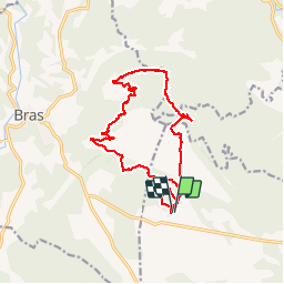
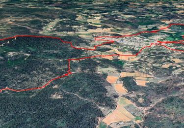
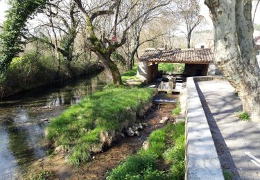
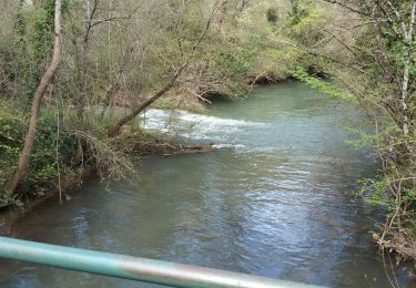
Tocht Stappen van 17,6 km beschikbaar op Provence-Alpes-Côte d'Azur, Var, Le Val. Deze tocht wordt voorgesteld door Sugg.
Beschrijving
Rando réelle du 6 juin 2018.
7 au départ.
plutôt sur la commune du Val !
J'avais prévu de finir la boucle plus au sud sous la D28 mais un peu long !
Plaatsbepaling
Land:
France
Regio :
Provence-Alpes-Côte d'Azur
Departement/Provincie :
Var
Gemeente :
Le Val
Locatie:
Unknown
Vertrek:(Dec)
Vertrek:(UTM)
742634 ; 4815158 (31T) N.
Opmerkingen
Wandeltochten in de omgeving
![Tocht Stappen Bras - 29+Bras+-+Collines+du+Drens+2020 - Photo](https://media.geolcdn.com/t/375/260/47ad5a28-8176-42c0-9d8e-3872979b11bc.jpg&format=jpg&maxdim=2)
![Stappen Stappen](https://static1.geolcdn.com/sitytour/trail-icons/101.png)
29+Bras+-+Collines+du+Drens+2020
Stappen
Medium
(1)
Bras,
Provence-Alpes-Côte d'Azur,
Var,
France
![](/images/other/stat-length.png)
14 km | 21 km-effort
6h 0min
![](https://static1.geolcdn.com/siteimages/upload/files/16400158638029165_repeat_loop_refresh_sync_direction_icon.png)
Ja
![Tocht Stappen Bras - Chutes du tombereau - Photo](https://media.geolcdn.com/t/375/260/3ed533da-12d6-4a04-9744-f8536921f316.jpg&format=jpg&maxdim=2)
![Stappen Stappen](https://static1.geolcdn.com/sitytour/trail-icons/101.png)
Chutes du tombereau
Stappen
Gemakkelijk
(1)
Bras,
Provence-Alpes-Côte d'Azur,
Var,
France
![](/images/other/stat-length.png)
11,1 km | 13,6 km-effort
2h 42min
![](https://static1.geolcdn.com/siteimages/upload/files/16400158638029165_repeat_loop_refresh_sync_direction_icon.png)
Ja
![Tocht Te voet Bras - Chute du Tombereau, Bras 11-10-2024 - Photo](https://media.geolcdn.com/t/375/260/860cd67c-b6a3-4437-878e-156ccdca5542.jpg&format=jpg&maxdim=2)
![Te voet Te voet](https://static1.geolcdn.com/sitytour/trail-icons/100.png)
Chute du Tombereau, Bras 11-10-2024
Te voet
Gemakkelijk
Bras,
Provence-Alpes-Côte d'Azur,
Var,
France
![](/images/other/stat-length.png)
14,7 km | 18,2 km-effort
4h 8min
![](https://static1.geolcdn.com/siteimages/upload/files/16400158638029165_repeat_loop_refresh_sync_direction_icon.png)
Ja
![Tocht sport Bras - Bras Martine - Photo](https://media.geolcdn.com/t/375/260/92424973-da8f-45dd-b870-2b8efea2ae3b.jpg&format=jpg&maxdim=2)
Bras Martine
sport
Heel gemakkelijk
(1)
Bras,
Provence-Alpes-Côte d'Azur,
Var,
France
![](/images/other/stat-length.png)
12,3 km | 15,6 km-effort
Onbekend
![](https://static1.geolcdn.com/siteimages/upload/files/16400158638029165_repeat_loop_refresh_sync_direction_icon.png)
Ja
![Tocht Stappen Bras - Bras jeudi 10/02/2022 Martine - Photo](https://media.geolcdn.com/t/375/260/b21c62da-7a83-4fcf-a674-3504e8c67f06.jpg&format=jpg&maxdim=2)
![Stappen Stappen](https://static1.geolcdn.com/sitytour/trail-icons/101.png)
Bras jeudi 10/02/2022 Martine
Stappen
Moeilijk
Bras,
Provence-Alpes-Côte d'Azur,
Var,
France
![](/images/other/stat-length.png)
15,1 km | 18,3 km-effort
4h 24min
![](https://static1.geolcdn.com/siteimages/upload/files/16400158638029165_repeat_loop_refresh_sync_direction_icon.png)
Neen
![Tocht Stappen Bras - Bras - Photo](https://media.geolcdn.com/t/375/260/a7a6d44b-4aa6-4c28-978c-deb3e4b9a501.jpg&format=jpg&maxdim=2)
![Stappen Stappen](https://static1.geolcdn.com/sitytour/trail-icons/101.png)
Bras
Stappen
Gemakkelijk
(1)
Bras,
Provence-Alpes-Côte d'Azur,
Var,
France
![](/images/other/stat-length.png)
15 km | 18,3 km-effort
3h 33min
![](https://static1.geolcdn.com/siteimages/upload/files/16400158638029165_repeat_loop_refresh_sync_direction_icon.png)
Ja
![Tocht Stappen Bras - 20190414 reco partielle Bras Le Tombereau - Photo](https://media.geolcdn.com/t/375/260/aa3c4189-1fb5-4f4f-b81a-5f04b149b2b5.jpg&format=jpg&maxdim=2)
![Stappen Stappen](https://static1.geolcdn.com/sitytour/trail-icons/101.png)
20190414 reco partielle Bras Le Tombereau
Stappen
Gemakkelijk
Bras,
Provence-Alpes-Côte d'Azur,
Var,
France
![](/images/other/stat-length.png)
15,5 km | 18,7 km-effort
4h 25min
![](https://static1.geolcdn.com/siteimages/upload/files/16400158638029165_repeat_loop_refresh_sync_direction_icon.png)
Neen
![Tocht Stappen Correns - Correns - Le val Sourn - Photo](https://media.geolcdn.com/t/375/260/ext.jpg?maxdim=2&url=https%3A%2F%2Fstatic1.geolcdn.com%2Fsiteimages%2Fupload%2Ffiles%2F1553511878bg_sport_marche.png)
![Stappen Stappen](https://static1.geolcdn.com/sitytour/trail-icons/101.png)
Correns - Le val Sourn
Stappen
Medium
(1)
Correns,
Provence-Alpes-Côte d'Azur,
Var,
France
![](/images/other/stat-length.png)
11,2 km | 15,2 km-effort
3h 16min
![](https://static1.geolcdn.com/siteimages/upload/files/16400158638029165_repeat_loop_refresh_sync_direction_icon.png)
Ja
![Tocht Stappen Le Val - Montée du Cuit - Photo](https://media.geolcdn.com/t/375/260/ext.jpg?maxdim=2&url=https%3A%2F%2Fstatic1.geolcdn.com%2Fsiteimages%2Fupload%2Ffiles%2F1553511878bg_sport_marche.png)
![Stappen Stappen](https://static1.geolcdn.com/sitytour/trail-icons/101.png)
Montée du Cuit
Stappen
Medium
(1)
Le Val,
Provence-Alpes-Côte d'Azur,
Var,
France
![](/images/other/stat-length.png)
7,3 km | 11 km-effort
1h 50min
![](https://static1.geolcdn.com/siteimages/upload/files/16400158638029165_repeat_loop_refresh_sync_direction_icon.png)
Ja