![](/images/other/stat-length.png)
![Tocht Stappen Castellet-lès-Sausses - Col du Fa - Aurent - Argenton - Photo](https://media.geolcdn.com/t/1900/400/ext.pjpeg?maxdim=2&url=https%3A%2F%2Fstatic1.geolcdn.com%2Fsiteimages%2Fupload%2Ffiles%2F1553511878bg_sport_marche.png)
Col du Fa - Aurent - Argenton
GrouGary
Gebruiker
![Lengte](/images/other/stat-length.png)
Lengte
13,2 km
![Max. hoogte](https://static1.geolcdn.com/siteimages/upload/files/1508320355ic_sort_altitude_max_24dp.png)
Max. hoogte
1390 m
![Positief hoogteverschil](https://static1.geolcdn.com/siteimages/upload/files/1508320355ic_sort_den_pos_24dp.png)
Positief hoogteverschil
652 m
![Km-Effort](/images/other/stat-length.png)
Km-Effort
22 km
![Min. hoogte](https://static1.geolcdn.com/siteimages/upload/files/1508320355ic_sort_altitude_min_24dp.png)
Min. hoogte
1007 m
![Negatief hoogteverschil](https://static1.geolcdn.com/siteimages/upload/files/1508320355ic_sort_den_neg_24dp.png)
Negatief hoogteverschil
650 m
![Boucle](https://static1.geolcdn.com/siteimages/upload/files/16400158638029165_repeat_loop_refresh_sync_direction_icon.png)
Boucle
Ja
Datum van aanmaak :
2018-06-26 14:23:01.241
Laatste wijziging :
2018-06-26 14:23:01.241
![Stappen](https://static1.geolcdn.com/sitytour/trail-icons/101.png)
4h51
Moeilijkheid : Medium
![Scan deze QR-code om de tocht te openen in de SityTrail-applicatie](https://capi.geolives.com/qq0zvz2zws4bq2lad0pu/sitytour/trails/969751/qr.png?size=200)
Gratisgps-wandelapplicatie
Over ons
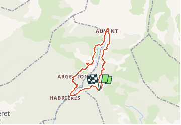
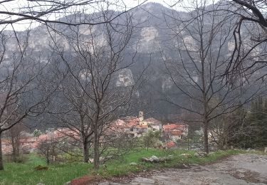
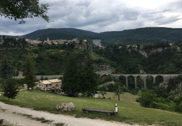
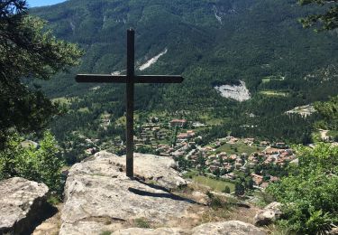
Tocht Stappen van 13,2 km beschikbaar op Provence-Alpes-Côte d'Azur, Alpes-de-Haute-Provence, Castellet-lès-Sausses. Deze tocht wordt voorgesteld door GrouGary.
Beschrijving
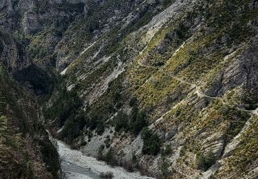
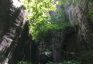
Circuit en boucle, A/R sur la rivière du Coulomp.
Entre Aurent et Argenton, quelques passages exposés et dangereux sur cône d'éboulis.
Plaatsbepaling
Land:
France
Regio :
Provence-Alpes-Côte d'Azur
Departement/Provincie :
Alpes-de-Haute-Provence
Gemeente :
Castellet-lès-Sausses
Locatie:
Unknown
Vertrek:(Dec)
Vertrek:(UTM)
316746 ; 4876145 (32T) N.
Opmerkingen
Wandeltochten in de omgeving
![Tocht Ski randonnée Castellet-lès-Sausses - mourre Frey te tête de travers - Photo](https://media.geolcdn.com/t/375/260/1b767a21-1868-437d-b876-59d00a73f0ab.jpg&format=jpg&maxdim=2)
![Ski randonnée Ski randonnée](https://static1.geolcdn.com/sitytour/trail-icons/503.png)
mourre Frey te tête de travers
Ski randonnée
Gemakkelijk
Castellet-lès-Sausses,
Provence-Alpes-Côte d'Azur,
Alpes-de-Haute-Provence,
France
![](/images/other/stat-length.png)
8,8 km | 21 km-effort
5h 1min
![](https://static1.geolcdn.com/siteimages/upload/files/16400158638029165_repeat_loop_refresh_sync_direction_icon.png)
Ja
![Tocht Stappen Castellet-lès-Sausses - Tête de travers et Mourre Frey, du Col du Fam - Photo](https://media.geolcdn.com/t/375/260/a4176451-cb19-4ec9-86ca-b1e3e647aa87.jpg&format=jpg&maxdim=2)
![Stappen Stappen](https://static1.geolcdn.com/sitytour/trail-icons/101.png)
Tête de travers et Mourre Frey, du Col du Fam
Stappen
Medium
(1)
Castellet-lès-Sausses,
Provence-Alpes-Côte d'Azur,
Alpes-de-Haute-Provence,
France
![](/images/other/stat-length.png)
11,9 km | 24 km-effort
5h 28min
![](https://static1.geolcdn.com/siteimages/upload/files/16400158638029165_repeat_loop_refresh_sync_direction_icon.png)
Ja
![Tocht Stappen Braux - Rando Pieŕre qui tremble Chabrieres Peloussis Argenton - Photo](https://media.geolcdn.com/t/375/260/cfc0cc00-9a69-459b-9e00-f152d8d54736.jpg&format=jpg&maxdim=2)
![Stappen Stappen](https://static1.geolcdn.com/sitytour/trail-icons/101.png)
Rando Pieŕre qui tremble Chabrieres Peloussis Argenton
Stappen
Medium
Braux,
Provence-Alpes-Côte d'Azur,
Alpes-de-Haute-Provence,
France
![](/images/other/stat-length.png)
14 km | 22 km-effort
6h 27min
![](https://static1.geolcdn.com/siteimages/upload/files/16400158638029165_repeat_loop_refresh_sync_direction_icon.png)
Ja
![Tocht Stappen Braux - Chabrieres,Pelloussis,Argenton, Aurent, Col du Fa,Le Coulomp - Photo](https://media.geolcdn.com/t/375/260/f6f9a83c-04ee-40b9-a5e8-e4ac69620223.jpg&format=jpg&maxdim=2)
![Stappen Stappen](https://static1.geolcdn.com/sitytour/trail-icons/101.png)
Chabrieres,Pelloussis,Argenton, Aurent, Col du Fa,Le Coulomp
Stappen
Zeer moeilijk
Braux,
Provence-Alpes-Côte d'Azur,
Alpes-de-Haute-Provence,
France
![](/images/other/stat-length.png)
16,4 km | 27 km-effort
7h 18min
![](https://static1.geolcdn.com/siteimages/upload/files/16400158638029165_repeat_loop_refresh_sync_direction_icon.png)
Ja
![Tocht Stappen Braux - Canal de Braux Créte du Clôt Martin - Photo](https://media.geolcdn.com/t/375/260/750c766f-b28a-4536-81b9-25d4ffd2efbc.jpg&format=jpg&maxdim=2)
![Stappen Stappen](https://static1.geolcdn.com/sitytour/trail-icons/101.png)
Canal de Braux Créte du Clôt Martin
Stappen
Medium
Braux,
Provence-Alpes-Côte d'Azur,
Alpes-de-Haute-Provence,
France
![](/images/other/stat-length.png)
21 km | 31 km-effort
8h 4min
![](https://static1.geolcdn.com/siteimages/upload/files/16400158638029165_repeat_loop_refresh_sync_direction_icon.png)
Ja
![Tocht Elektrische fiets Annot - Annot - Peresq - Photo](https://media.geolcdn.com/t/375/260/f9d6f0d3-2fb5-435d-b41a-baaa9e1dae8a.jpg&format=jpg&maxdim=2)
![Elektrische fiets Elektrische fiets](https://static1.geolcdn.com/sitytour/trail-icons/205.png)
Annot - Peresq
Elektrische fiets
Medium
Annot,
Provence-Alpes-Côte d'Azur,
Alpes-de-Haute-Provence,
France
![](/images/other/stat-length.png)
38 km | 52 km-effort
2h 19min
![](https://static1.geolcdn.com/siteimages/upload/files/16400158638029165_repeat_loop_refresh_sync_direction_icon.png)
Ja
![Tocht Stappen Annot - Les grés d'Annot: Jardins et chambre du Roi - Photo](https://media.geolcdn.com/t/375/260/2b865830-3fe2-49c9-9a69-3696cb0f2f88.jpg&format=jpg&maxdim=2)
![Stappen Stappen](https://static1.geolcdn.com/sitytour/trail-icons/101.png)
Les grés d'Annot: Jardins et chambre du Roi
Stappen
Medium
Annot,
Provence-Alpes-Côte d'Azur,
Alpes-de-Haute-Provence,
France
![](/images/other/stat-length.png)
8,7 km | 14,3 km-effort
3h 1min
![](https://static1.geolcdn.com/siteimages/upload/files/16400158638029165_repeat_loop_refresh_sync_direction_icon.png)
Ja
![Tocht Stappen Castellet-lès-Sausses - retour par Balmont - Photo](https://media.geolcdn.com/t/375/260/f87c59e6-3944-40d3-a949-79bed44c35f4.jpg&format=jpg&maxdim=2)
![Stappen Stappen](https://static1.geolcdn.com/sitytour/trail-icons/101.png)
retour par Balmont
Stappen
Medium
Castellet-lès-Sausses,
Provence-Alpes-Côte d'Azur,
Alpes-de-Haute-Provence,
France
![](/images/other/stat-length.png)
6,3 km | 8,6 km-effort
1h 55min
![](https://static1.geolcdn.com/siteimages/upload/files/16400158638029165_repeat_loop_refresh_sync_direction_icon.png)
Neen
![Tocht Stappen Annot - baou-de-parou - Photo](https://media.geolcdn.com/t/375/260/3aa1988d-245e-4273-8eb3-d20ff83d89e8.jpg&format=jpg&maxdim=2)
![Stappen Stappen](https://static1.geolcdn.com/sitytour/trail-icons/101.png)
baou-de-parou
Stappen
Annot,
Provence-Alpes-Côte d'Azur,
Alpes-de-Haute-Provence,
France
![](/images/other/stat-length.png)
7,2 km | 13,4 km-effort
2h 39min
![](https://static1.geolcdn.com/siteimages/upload/files/16400158638029165_repeat_loop_refresh_sync_direction_icon.png)
Ja