![](/images/other/stat-length.png)
![Tocht Stappen Val-de-Ruz - Tête de Ran - Racine - Petits ponts : Crêtes - Photo](https://media.geolcdn.com/t/1900/400/ext.pjpeg?maxdim=2&url=https%3A%2F%2Fstatic1.geolcdn.com%2Fsiteimages%2Fupload%2Ffiles%2F1553511878bg_sport_marche.png)
Tête de Ran - Racine - Petits ponts : Crêtes
philmail
Gebruiker
![Lengte](/images/other/stat-length.png)
Lengte
21 km
![Max. hoogte](https://static1.geolcdn.com/siteimages/upload/files/1508320355ic_sort_altitude_max_24dp.png)
Max. hoogte
1412 m
![Positief hoogteverschil](https://static1.geolcdn.com/siteimages/upload/files/1508320355ic_sort_den_pos_24dp.png)
Positief hoogteverschil
663 m
![Km-Effort](/images/other/stat-length.png)
Km-Effort
30 km
![Min. hoogte](https://static1.geolcdn.com/siteimages/upload/files/1508320355ic_sort_altitude_min_24dp.png)
Min. hoogte
998 m
![Negatief hoogteverschil](https://static1.geolcdn.com/siteimages/upload/files/1508320355ic_sort_den_neg_24dp.png)
Negatief hoogteverschil
655 m
![Boucle](https://static1.geolcdn.com/siteimages/upload/files/16400158638029165_repeat_loop_refresh_sync_direction_icon.png)
Boucle
Ja
Datum van aanmaak :
2014-12-10 00:00:00.0
Laatste wijziging :
2014-12-10 00:00:00.0
![Stappen](https://static1.geolcdn.com/sitytour/trail-icons/101.png)
5h50
Moeilijkheid : Medium
![Scan deze QR-code om de tocht te openen in de SityTrail-applicatie](https://capi.geolives.com/qq0zvz2zws4bq2lad0pu/sitytour/trails/96775/qr.png?size=200)
Gratisgps-wandelapplicatie
Over ons
Tocht Stappen van 21 km beschikbaar op Neuchâtel, Onbekend, Val-de-Ruz. Deze tocht wordt voorgesteld door philmail.
Beschrijving
2 Ballades en une. De tête de Ran et retour par les Loges. Ou plus loin jusqu'aux petits ponts et retour... Relativement "plat", très agréable, panoramiques à couper le souffle de tous les côtés !
Plaatsbepaling
Land:
Switzerland
Regio :
Neuchâtel
Departement/Provincie :
Onbekend
Gemeente :
Val-de-Ruz
Locatie:
Les Hauts-Geneveys
Vertrek:(Dec)
Vertrek:(UTM)
337170 ; 5213569 (32T) N.
Opmerkingen
Wandeltochten in de omgeving
![Tocht Te voet La Chaux-de-Fonds - La Chaux-de-Fonds - Saut du Doubs - Photo](https://media.geolcdn.com/t/375/260/e6429c78-51f2-4265-a7d3-a2fdd44acab9.jpeg&format=jpg&maxdim=2)
![Te voet Te voet](https://static1.geolcdn.com/sitytour/trail-icons/100.png)
La Chaux-de-Fonds - Saut du Doubs
Te voet
Gemakkelijk
La Chaux-de-Fonds,
Neuchâtel,
Onbekend,
Switzerland
![](/images/other/stat-length.png)
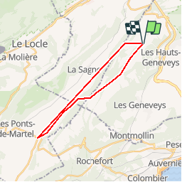
13,1 km | 18,5 km-effort
4h 12min
![](https://static1.geolcdn.com/siteimages/upload/files/16400158638029165_repeat_loop_refresh_sync_direction_icon.png)
Neen
![Tocht Te voet Val-de-Ruz - Mont Dar - Vue des Alpes - Photo](https://media.geolcdn.com/t/375/260/e749b2eb-93da-4562-bb4d-f0c0275db1c0.jpeg&format=jpg&maxdim=2)
![Te voet Te voet](https://static1.geolcdn.com/sitytour/trail-icons/100.png)
Mont Dar - Vue des Alpes
Te voet
Gemakkelijk
Val-de-Ruz,
Neuchâtel,
Onbekend,
Switzerland
![](/images/other/stat-length.png)
4,4 km | 7 km-effort
1h 35min
![](https://static1.geolcdn.com/siteimages/upload/files/16400158638029165_repeat_loop_refresh_sync_direction_icon.png)
Neen
![Tocht Te voet Val-de-Ruz - Grand Chezard-Villars - Photo](https://media.geolcdn.com/t/375/260/3bf5ff30-7d47-4dfe-9d27-eeef3ea7f5c4.jpeg&format=jpg&maxdim=2)
![Te voet Te voet](https://static1.geolcdn.com/sitytour/trail-icons/100.png)
Grand Chezard-Villars
Te voet
Gemakkelijk
Val-de-Ruz,
Neuchâtel,
Onbekend,
Switzerland
![](/images/other/stat-length.png)
4,3 km | 5,3 km-effort
1h 11min
![](https://static1.geolcdn.com/siteimages/upload/files/16400158638029165_repeat_loop_refresh_sync_direction_icon.png)
Neen
![Tocht Te voet Neuchâtel - Valangin - Serroue - Photo](https://media.geolcdn.com/t/375/260/07c9ba61-39b6-4bdc-a450-07ef30b251ee.jpeg&format=jpg&maxdim=2)
![Te voet Te voet](https://static1.geolcdn.com/sitytour/trail-icons/100.png)
Valangin - Serroue
Te voet
Gemakkelijk
Neuchâtel,
Neuchâtel,
Onbekend,
Switzerland
![](/images/other/stat-length.png)
3,1 km | 4,7 km-effort
1h 4min
![](https://static1.geolcdn.com/siteimages/upload/files/16400158638029165_repeat_loop_refresh_sync_direction_icon.png)
Neen
![Tocht Te voet Val-de-Ruz - Vue des Alpes - La Pouette Mange - Photo](https://media.geolcdn.com/t/375/260/e749b2eb-93da-4562-bb4d-f0c0275db1c0.jpeg&format=jpg&maxdim=2)
![Te voet Te voet](https://static1.geolcdn.com/sitytour/trail-icons/100.png)
Vue des Alpes - La Pouette Mange
Te voet
Gemakkelijk
Val-de-Ruz,
Neuchâtel,
Onbekend,
Switzerland
![](/images/other/stat-length.png)
4,2 km | 5,3 km-effort
1h 11min
![](https://static1.geolcdn.com/siteimages/upload/files/16400158638029165_repeat_loop_refresh_sync_direction_icon.png)
Neen
![Tocht Te voet Val-de-Ruz - Mont Dar - Le Reymond - Photo](https://media.geolcdn.com/t/375/260/ext.jpg?maxdim=2&url=https%3A%2F%2Fstatic1.geolcdn.com%2Fsiteimages%2Fupload%2Ffiles%2F1545311037marcheuse_200dpi.jpg)
![Te voet Te voet](https://static1.geolcdn.com/sitytour/trail-icons/100.png)
Mont Dar - Le Reymond
Te voet
Gemakkelijk
Val-de-Ruz,
Neuchâtel,
Onbekend,
Switzerland
![](/images/other/stat-length.png)
5,7 km | 9 km-effort
2h 2min
![](https://static1.geolcdn.com/siteimages/upload/files/16400158638029165_repeat_loop_refresh_sync_direction_icon.png)
Neen
![Tocht Te voet Val-de-Ruz - Mont Dar - fixme - Photo](https://media.geolcdn.com/t/375/260/ext.jpg?maxdim=2&url=https%3A%2F%2Fstatic1.geolcdn.com%2Fsiteimages%2Fupload%2Ffiles%2F1545311037marcheuse_200dpi.jpg)
![Te voet Te voet](https://static1.geolcdn.com/sitytour/trail-icons/100.png)
Mont Dar - fixme
Te voet
Gemakkelijk
Val-de-Ruz,
Neuchâtel,
Onbekend,
Switzerland
![](/images/other/stat-length.png)
3,5 km | 6,2 km-effort
1h 23min
![](https://static1.geolcdn.com/siteimages/upload/files/16400158638029165_repeat_loop_refresh_sync_direction_icon.png)
Neen
![Tocht Stappen La Sagne - 09-11-19 sentier des statues - Photo](https://media.geolcdn.com/t/375/260/8ec1ec16-900d-4af5-a961-120cad232354.jpg&format=jpg&maxdim=2)
![Stappen Stappen](https://static1.geolcdn.com/sitytour/trail-icons/101.png)
09-11-19 sentier des statues
Stappen
Gemakkelijk
La Sagne,
Neuchâtel,
Onbekend,
Switzerland
![](/images/other/stat-length.png)
6 km | 9,3 km-effort
2h 5min
![](https://static1.geolcdn.com/siteimages/upload/files/16400158638029165_repeat_loop_refresh_sync_direction_icon.png)
Neen
![Tocht Fiets La Chaux-de-Fonds - La Chaux de Fonds - St. Ursanne (Jura Suisse) - Photo](https://media.geolcdn.com/t/375/260/ext.jpg?maxdim=2&url=https%3A%2F%2Fservices.sitytrail.com%2FGeolivesWS%2FDownloadMedia.ashx%3FTrailID%3D817688%26Media%3Dfix__20170824162433.jpg)
![Fiets Fiets](https://static1.geolcdn.com/sitytour/trail-icons/200.png)
La Chaux de Fonds - St. Ursanne (Jura Suisse)
Fiets
Gemakkelijk
La Chaux-de-Fonds,
Neuchâtel,
Onbekend,
Switzerland
![](/images/other/stat-length.png)
62 km | 76 km-effort
5h 17min
![](https://static1.geolcdn.com/siteimages/upload/files/16400158638029165_repeat_loop_refresh_sync_direction_icon.png)
Neen