![](/images/other/stat-length.png)
![Tocht Paard Vigneux-de-Bretagne - boucle de la Paquelais - Photo](https://media.geolcdn.com/t/1900/400/ext.pjpeg?maxdim=2&url=https%3A%2F%2Fstatic1.geolcdn.com%2Fsiteimages%2Fupload%2Ffiles%2F1524743154cheval.jpg)
boucle de la Paquelais
Sevie44
Gebruiker
![Lengte](/images/other/stat-length.png)
Lengte
8,8 km
![Max. hoogte](https://static1.geolcdn.com/siteimages/upload/files/1508320355ic_sort_altitude_max_24dp.png)
Max. hoogte
77 m
![Positief hoogteverschil](https://static1.geolcdn.com/siteimages/upload/files/1508320355ic_sort_den_pos_24dp.png)
Positief hoogteverschil
115 m
![Km-Effort](/images/other/stat-length.png)
Km-Effort
10,4 km
![Min. hoogte](https://static1.geolcdn.com/siteimages/upload/files/1508320355ic_sort_altitude_min_24dp.png)
Min. hoogte
35 m
![Negatief hoogteverschil](https://static1.geolcdn.com/siteimages/upload/files/1508320355ic_sort_den_neg_24dp.png)
Negatief hoogteverschil
115 m
![Boucle](https://static1.geolcdn.com/siteimages/upload/files/16400158638029165_repeat_loop_refresh_sync_direction_icon.png)
Boucle
Ja
Datum van aanmaak :
2018-06-26 13:42:10.936
Laatste wijziging :
2018-06-26 13:42:10.936
![Paard](https://static1.geolcdn.com/sitytour/trail-icons/300.png)
1h29
Moeilijkheid : Medium
![Scan deze QR-code om de tocht te openen in de SityTrail-applicatie](https://capi.geolives.com/qq0zvz2zws4bq2lad0pu/sitytour/trails/963687/qr.png?size=200)
Gratisgps-wandelapplicatie
Over ons
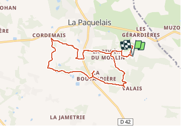
Tocht Paard van 8,8 km beschikbaar op Pays de la Loire, Loire-Atlantique, Vigneux-de-Bretagne. Deze tocht wordt voorgesteld door Sevie44.
Beschrijving
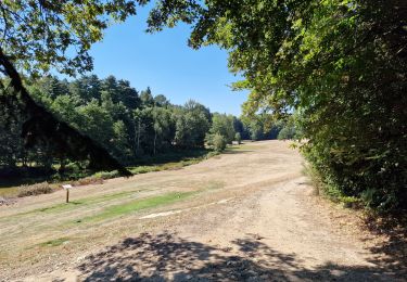
première boucle avec Safran au départ du centre équestre de la CLÉ
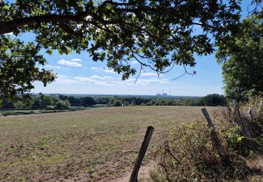
très beaux chemins boisés, un peu de cailloux et d'eau
Plaatsbepaling
Land:
France
Regio :
Pays de la Loire
Departement/Provincie :
Loire-Atlantique
Gemeente :
Vigneux-de-Bretagne
Locatie:
Unknown
Vertrek:(Dec)
Vertrek:(UTM)
599639 ; 5242224 (30T) N.
Opmerkingen
Wandeltochten in de omgeving
![Tocht Te voet Vigneux-de-Bretagne - Le pic vert - Photo](https://media.geolcdn.com/t/375/260/e485ad9f-6a4a-4b57-b44f-601646119e4d.jpeg&format=jpg&maxdim=2)
![Te voet Te voet](https://static1.geolcdn.com/sitytour/trail-icons/100.png)
Le pic vert
Te voet
Gemakkelijk
Vigneux-de-Bretagne,
Pays de la Loire,
Loire-Atlantique,
France
![](/images/other/stat-length.png)
12,2 km | 13,3 km-effort
3h 1min
![](https://static1.geolcdn.com/siteimages/upload/files/16400158638029165_repeat_loop_refresh_sync_direction_icon.png)
Ja
![Tocht Te voet Treillières - La Vallée du Gesvres - Photo](https://media.geolcdn.com/t/375/260/8559773a-c69a-4cdf-aa57-f4164f184ec9.jpeg&format=jpg&maxdim=2)
![Te voet Te voet](https://static1.geolcdn.com/sitytour/trail-icons/100.png)
La Vallée du Gesvres
Te voet
Gemakkelijk
Treillières,
Pays de la Loire,
Loire-Atlantique,
France
![](/images/other/stat-length.png)
8,7 km | 10,1 km-effort
2h 18min
![](https://static1.geolcdn.com/siteimages/upload/files/16400158638029165_repeat_loop_refresh_sync_direction_icon.png)
Neen
![Tocht Stappen Vigneux-de-Bretagne - De Vigneux de Bretagne à Le Temple de Bretagne - Photo](https://media.geolcdn.com/t/375/260/cb8c8c9d-7e83-4f79-bbaf-b9d8468d333c.jpg&format=jpg&maxdim=2)
![Stappen Stappen](https://static1.geolcdn.com/sitytour/trail-icons/101.png)
De Vigneux de Bretagne à Le Temple de Bretagne
Stappen
Zeer moeilijk
Vigneux-de-Bretagne,
Pays de la Loire,
Loire-Atlantique,
France
![](/images/other/stat-length.png)
30 km | 35 km-effort
26h 14min
![](https://static1.geolcdn.com/siteimages/upload/files/16400158638029165_repeat_loop_refresh_sync_direction_icon.png)
Neen
![Tocht Te voet Notre-Dame-des-Landes - La chauve-souris - Photo](https://media.geolcdn.com/t/375/260/cf2847e8-63ef-484b-bdeb-a30aa23defd2.jpeg&format=jpg&maxdim=2)
![Te voet Te voet](https://static1.geolcdn.com/sitytour/trail-icons/100.png)
La chauve-souris
Te voet
Gemakkelijk
Notre-Dame-des-Landes,
Pays de la Loire,
Loire-Atlantique,
France
![](/images/other/stat-length.png)
9 km | 9,7 km-effort
2h 12min
![](https://static1.geolcdn.com/siteimages/upload/files/16400158638029165_repeat_loop_refresh_sync_direction_icon.png)
Ja
![Tocht Stappen Vigneux-de-Bretagne - la Paquelais - Photo](https://media.geolcdn.com/t/375/260/ext.jpg?maxdim=2&url=https%3A%2F%2Fstatic1.geolcdn.com%2Fsiteimages%2Fupload%2Ffiles%2F1553511878bg_sport_marche.png)
![Stappen Stappen](https://static1.geolcdn.com/sitytour/trail-icons/101.png)
la Paquelais
Stappen
Gemakkelijk
(1)
Vigneux-de-Bretagne,
Pays de la Loire,
Loire-Atlantique,
France
![](/images/other/stat-length.png)
15,4 km | 17,6 km-effort
3h 50min
![](https://static1.geolcdn.com/siteimages/upload/files/16400158638029165_repeat_loop_refresh_sync_direction_icon.png)
Ja
![Tocht Fiets Sautron - sautron-noirmoutier - Photo](https://media.geolcdn.com/t/375/260/ext.jpg?maxdim=2&url=https%3A%2F%2Fservices.sitytrail.com%2FGeolivesWS%2FDownloadMedia.ashx%3FTrailID%3D152148%26Media%3D20120907135102.jpeg)
![Fiets Fiets](https://static1.geolcdn.com/sitytour/trail-icons/200.png)
sautron-noirmoutier
Fiets
Medium
Sautron,
Pays de la Loire,
Loire-Atlantique,
France
![](/images/other/stat-length.png)
82 km | 87 km-effort
4h 49min
![](https://static1.geolcdn.com/siteimages/upload/files/16400158638029165_repeat_loop_refresh_sync_direction_icon.png)
Neen
![Tocht Fiets Sautron - sautron-noirmoutier - Photo](https://media.geolcdn.com/t/375/260/ext.jpg?maxdim=2&url=https%3A%2F%2Fservices.sitytrail.com%2FGeolivesWS%2FDownloadMedia.ashx%3FTrailID%3D152147%26Media%3D20120907135102.jpeg)
![Fiets Fiets](https://static1.geolcdn.com/sitytour/trail-icons/200.png)
sautron-noirmoutier
Fiets
Medium
Sautron,
Pays de la Loire,
Loire-Atlantique,
France
![](/images/other/stat-length.png)
82 km | 87 km-effort
4h 48min
![](https://static1.geolcdn.com/siteimages/upload/files/16400158638029165_repeat_loop_refresh_sync_direction_icon.png)
Neen
![Tocht Stappen Treillières - 2010-08-03 - 16h42m56 - Photo](https://media.geolcdn.com/t/375/260/ext.jpg?maxdim=2&url=https%3A%2F%2Fservices.sitytrail.com%2FGeolivesWS%2FDownloadMedia.ashx%3FTrailID%3D42883%26Media%3Dimage3.jpg)
![Stappen Stappen](https://static1.geolcdn.com/sitytour/trail-icons/101.png)
2010-08-03 - 16h42m56
Stappen
Heel gemakkelijk
Treillières,
Pays de la Loire,
Loire-Atlantique,
France
![](/images/other/stat-length.png)
745 km | 1181 km-effort
Onbekend
![](https://static1.geolcdn.com/siteimages/upload/files/16400158638029165_repeat_loop_refresh_sync_direction_icon.png)
Neen
![Tocht Stappen Vigneux-de-Bretagne - de Vigneux de Bretagne à Saint Étienne de Montluc - Photo](https://media.geolcdn.com/t/375/260/ae9dc19f-b297-4671-ae8f-96d088e87fd9.jpg&format=jpg&maxdim=2)
![Stappen Stappen](https://static1.geolcdn.com/sitytour/trail-icons/101.png)
de Vigneux de Bretagne à Saint Étienne de Montluc
Stappen
Moeilijk
Vigneux-de-Bretagne,
Pays de la Loire,
Loire-Atlantique,
France
![](/images/other/stat-length.png)
15,7 km | 17,8 km-effort
3h 25min
![](https://static1.geolcdn.com/siteimages/upload/files/16400158638029165_repeat_loop_refresh_sync_direction_icon.png)
Neen