![](/images/other/stat-length.png)
![Tocht Stappen Rouen - Moulins du Robec et Cote Ste CatherineNouveau guide - Photo](https://media.geolcdn.com/t/1900/400/ext.pjpeg?maxdim=2&url=https%3A%2F%2Fstatic1.geolcdn.com%2Fsiteimages%2Fupload%2Ffiles%2F1553511878bg_sport_marche.png)
Moulins du Robec et Cote Ste CatherineNouveau guide
randojj
Gebruiker
![Lengte](/images/other/stat-length.png)
Lengte
12 km
![Max. hoogte](https://static1.geolcdn.com/siteimages/upload/files/1508320355ic_sort_altitude_max_24dp.png)
Max. hoogte
149 m
![Positief hoogteverschil](https://static1.geolcdn.com/siteimages/upload/files/1508320355ic_sort_den_pos_24dp.png)
Positief hoogteverschil
227 m
![Km-Effort](/images/other/stat-length.png)
Km-Effort
15,1 km
![Min. hoogte](https://static1.geolcdn.com/siteimages/upload/files/1508320355ic_sort_altitude_min_24dp.png)
Min. hoogte
7 m
![Negatief hoogteverschil](https://static1.geolcdn.com/siteimages/upload/files/1508320355ic_sort_den_neg_24dp.png)
Negatief hoogteverschil
228 m
![Boucle](https://static1.geolcdn.com/siteimages/upload/files/16400158638029165_repeat_loop_refresh_sync_direction_icon.png)
Boucle
Ja
Datum van aanmaak :
2019-04-26 07:45:17.064
Laatste wijziging :
2019-04-26 07:45:17.09
![Stappen](https://static1.geolcdn.com/sitytour/trail-icons/101.png)
3h20
Moeilijkheid : Medium
![Scan deze QR-code om de tocht te openen in de SityTrail-applicatie](https://capi.geolives.com/qq0zvz2zws4bq2lad0pu/sitytour/trails/945669/qr.png?size=200)
Gratisgps-wandelapplicatie
Over ons
Tocht Stappen van 12 km beschikbaar op Normandië, Seine-Maritime, Rouen. Deze tocht wordt voorgesteld door randojj.
Beschrijving
Départ du parvis de l'église St Hilaire.Revenir vers la place St Hilaire,puis prendre à gauche la rue de l'abreuvoir,derrière la clinique St Hilaire, ou l'on pourra admirer la maison du poète " Roger Gosseaume".
Plaatsbepaling
Land:
France
Regio :
Normandië
Departement/Provincie :
Seine-Maritime
Gemeente :
Rouen
Locatie:
Unknown
Vertrek:(Dec)
Vertrek:(UTM)
363449 ; 5478293 (31U) N.
Opmerkingen
Wandeltochten in de omgeving
![Tocht Stappen Mont-Saint-Aignan - Mont-saint-aignan - Chasse-Marée - - Photo](https://media.geolcdn.com/t/375/260/ext.jpg?maxdim=2&url=https%3A%2F%2Fmedia.geolcdn.com%2Ff%2F9cf681a4-2bd4-44f5-95c9-4e27e69bf20e.jpg)
![Stappen Stappen](https://static1.geolcdn.com/sitytour/trail-icons/101.png)
Mont-saint-aignan - Chasse-Marée -
Stappen
Moeilijk
(1)
Mont-Saint-Aignan,
Normandië,
Seine-Maritime,
France
![](/images/other/stat-length.png)
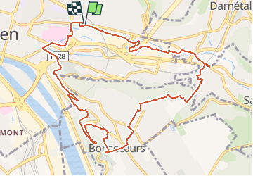
11,7 km | 15,2 km-effort
3h 27min
![](https://static1.geolcdn.com/siteimages/upload/files/16400158638029165_repeat_loop_refresh_sync_direction_icon.png)
Ja
![Tocht Stappen Darnétal - 076-34-le tour de Darnétal 13km 875-557 - Photo](https://media.geolcdn.com/t/375/260/ext.jpg?maxdim=2&url=https%3A%2F%2Fmedia.geolcdn.com%2Ff%2F8d6b313f-018e-4d0a-9167-39ef9b5d8712.JPG)
![Stappen Stappen](https://static1.geolcdn.com/sitytour/trail-icons/101.png)
076-34-le tour de Darnétal 13km 875-557
Stappen
Medium
(1)
Darnétal,
Normandië,
Seine-Maritime,
France
![](/images/other/stat-length.png)
9,8 km | 13,1 km-effort
3h 32min
![](https://static1.geolcdn.com/siteimages/upload/files/16400158638029165_repeat_loop_refresh_sync_direction_icon.png)
Ja
![Tocht Stappen Rouen - 076-102--Bonsecours Darnetal par St Hilaire 13km- - Photo](https://media.geolcdn.com/t/375/260/ext.jpg?maxdim=2&url=https%3A%2F%2Fmedia.geolcdn.com%2Ff%2Fdf16cd3f-22de-4a98-ae5c-66d89f1fbe2e.jpg)
![Stappen Stappen](https://static1.geolcdn.com/sitytour/trail-icons/101.png)
076-102--Bonsecours Darnetal par St Hilaire 13km-
Stappen
Medium
(1)
Rouen,
Normandië,
Seine-Maritime,
France
![](/images/other/stat-length.png)
13,1 km | 16 km-effort
21min
![](https://static1.geolcdn.com/siteimages/upload/files/16400158638029165_repeat_loop_refresh_sync_direction_icon.png)
Ja
![Tocht Stappen Darnétal - 20240108-Darnetal - Photo](https://media.geolcdn.com/t/375/260/ext.jpg?maxdim=2&url=https%3A%2F%2Fmedia.geolcdn.com%2Ff%2Fd166eaef-b4c4-4c08-9e4b-e31393ca7112.JPG)
![Stappen Stappen](https://static1.geolcdn.com/sitytour/trail-icons/101.png)
20240108-Darnetal
Stappen
Medium
Darnétal,
Normandië,
Seine-Maritime,
France
![](/images/other/stat-length.png)
10,1 km | 13,4 km-effort
3h 10min
![](https://static1.geolcdn.com/siteimages/upload/files/16400158638029165_repeat_loop_refresh_sync_direction_icon.png)
Ja
![Tocht Stappen Rouen - 20231109-Rouen - Photo](https://media.geolcdn.com/t/375/260/ext.jpg?maxdim=2&url=https%3A%2F%2Fmedia.geolcdn.com%2Ff%2F7e3ba228-59de-4bee-b079-3f87b9caf2a8.JPG)
![Stappen Stappen](https://static1.geolcdn.com/sitytour/trail-icons/101.png)
20231109-Rouen
Stappen
Gemakkelijk
Rouen,
Normandië,
Seine-Maritime,
France
![](/images/other/stat-length.png)
3,2 km | 3,6 km-effort
57min
![](https://static1.geolcdn.com/siteimages/upload/files/16400158638029165_repeat_loop_refresh_sync_direction_icon.png)
Ja
![Tocht Noords wandelen Bois-Guillaume - MN - Bois-Guillaume - Bretèque - Photo](https://media.geolcdn.com/t/375/260/ext.jpg?maxdim=2&url=https%3A%2F%2Fstatic1.geolcdn.com%2Fsiteimages%2Fupload%2Ffiles%2F1545311037marcheuse_200dpi.jpg)
![Noords wandelen Noords wandelen](https://static1.geolcdn.com/sitytour/trail-icons/102.png)
MN - Bois-Guillaume - Bretèque
Noords wandelen
Heel gemakkelijk
(1)
Bois-Guillaume,
Normandië,
Seine-Maritime,
France
![](/images/other/stat-length.png)
6,9 km | 7,9 km-effort
1h 15min
![](https://static1.geolcdn.com/siteimages/upload/files/16400158638029165_repeat_loop_refresh_sync_direction_icon.png)
Ja
![Tocht Stappen Déville-lès-Rouen - 20230829-Déville les Rouen - Photo](https://media.geolcdn.com/t/375/260/ext.jpg?maxdim=2&url=https%3A%2F%2Fmedia.geolcdn.com%2Ff%2Fa1bfb1dc-651d-48f6-b3a4-c9672c17c4e9.JPG)
![Stappen Stappen](https://static1.geolcdn.com/sitytour/trail-icons/101.png)
20230829-Déville les Rouen
Stappen
Medium
Déville-lès-Rouen,
Normandië,
Seine-Maritime,
France
![](/images/other/stat-length.png)
11,9 km | 16,3 km-effort
3h 38min
![](https://static1.geolcdn.com/siteimages/upload/files/16400158638029165_repeat_loop_refresh_sync_direction_icon.png)
Ja
![Tocht Stappen Amfreville-la-Mi-Voie - 20230520-Amfreville la Mi Voie - Photo](https://media.geolcdn.com/t/375/260/ext.jpg?maxdim=2&url=https%3A%2F%2Fmedia.geolcdn.com%2Ff%2F8896ed5b-1bc9-47a3-83a3-c79710cc5aa1.JPG)
![Stappen Stappen](https://static1.geolcdn.com/sitytour/trail-icons/101.png)
20230520-Amfreville la Mi Voie
Stappen
Medium
Amfreville-la-Mi-Voie,
Normandië,
Seine-Maritime,
France
![](/images/other/stat-length.png)
10,8 km | 13,9 km-effort
3h 4min
![](https://static1.geolcdn.com/siteimages/upload/files/16400158638029165_repeat_loop_refresh_sync_direction_icon.png)
Ja
![Tocht Stappen Déville-lès-Rouen - 20230504-Déville les Rouen - Photo](https://media.geolcdn.com/t/375/260/ext.jpg?maxdim=2&url=https%3A%2F%2Fmedia.geolcdn.com%2Ff%2Feed96392-23a7-4859-84f4-8afb1f8dae77.jpg)
![Stappen Stappen](https://static1.geolcdn.com/sitytour/trail-icons/101.png)
20230504-Déville les Rouen
Stappen
Medium
Déville-lès-Rouen,
Normandië,
Seine-Maritime,
France
![](/images/other/stat-length.png)
10,9 km | 15,2 km-effort
3h 31min
![](https://static1.geolcdn.com/siteimages/upload/files/16400158638029165_repeat_loop_refresh_sync_direction_icon.png)
Ja