![](/images/other/stat-length.png)
![Tocht Stappen La Croix-sur-Roudoule - Tête et crêtes de Pibossan en boucle - Photo](https://media.geolcdn.com/t/1900/400/ext.pjpeg?maxdim=2&url=https%3A%2F%2Fstatic1.geolcdn.com%2Fsiteimages%2Fupload%2Ffiles%2F1553511878bg_sport_marche.png)
Tête et crêtes de Pibossan en boucle
PEBREJOSIANE
Gebruiker
![Lengte](/images/other/stat-length.png)
Lengte
15,2 km
![Max. hoogte](https://static1.geolcdn.com/siteimages/upload/files/1508320355ic_sort_altitude_max_24dp.png)
Max. hoogte
1617 m
![Positief hoogteverschil](https://static1.geolcdn.com/siteimages/upload/files/1508320355ic_sort_den_pos_24dp.png)
Positief hoogteverschil
1048 m
![Km-Effort](/images/other/stat-length.png)
Km-Effort
29 km
![Min. hoogte](https://static1.geolcdn.com/siteimages/upload/files/1508320355ic_sort_altitude_min_24dp.png)
Min. hoogte
716 m
![Negatief hoogteverschil](https://static1.geolcdn.com/siteimages/upload/files/1508320355ic_sort_den_neg_24dp.png)
Negatief hoogteverschil
1050 m
![Boucle](https://static1.geolcdn.com/siteimages/upload/files/16400158638029165_repeat_loop_refresh_sync_direction_icon.png)
Boucle
Ja
Datum van aanmaak :
2018-04-17 23:32:45.936
Laatste wijziging :
2018-04-17 23:32:45.936
![Stappen](https://static1.geolcdn.com/sitytour/trail-icons/101.png)
8h24
Moeilijkheid : Medium
![Scan deze QR-code om de tocht te openen in de SityTrail-applicatie](https://capi.geolives.com/qq0zvz2zws4bq2lad0pu/sitytour/trails/935490/qr.png?size=200)
Gratisgps-wandelapplicatie
Over ons
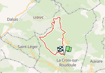
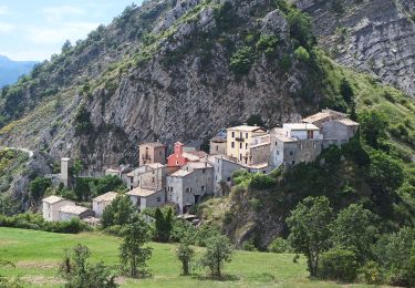
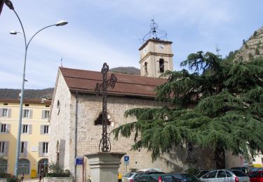
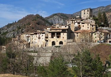
Tocht Stappen van 15,2 km beschikbaar op Provence-Alpes-Côte d'Azur, Alpes-Maritimes, La Croix-sur-Roudoule. Deze tocht wordt voorgesteld door PEBREJOSIANE.
Beschrijving
Départ et Arrivée b 233 route de Léouvé
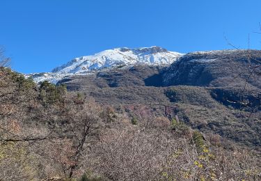
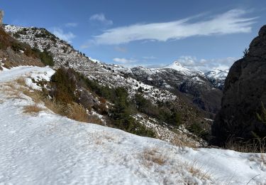
Cette randonnée nous conduit aux Amarines, Tête de Pibossan, collet Darmelle, Col de Roua, et retour sur les Amarines
1100 m de dénivelé et 5h effectives de marche
Plaatsbepaling
Land:
France
Regio :
Provence-Alpes-Côte d'Azur
Departement/Provincie :
Alpes-Maritimes
Gemeente :
La Croix-sur-Roudoule
Locatie:
Unknown
Vertrek:(Dec)
Vertrek:(UTM)
329282 ; 4873341 (32T) N.
Opmerkingen
Wandeltochten in de omgeving
![Tocht Te voet La Croix-sur-Roudoule - Tour du Mont d'Auvare - Photo](https://media.geolcdn.com/t/375/260/996cc198-4e38-4ec8-91f6-2dc8bedea61a.jpeg&format=jpg&maxdim=2)
![Te voet Te voet](https://static1.geolcdn.com/sitytour/trail-icons/100.png)
Tour du Mont d'Auvare
Te voet
Gemakkelijk
La Croix-sur-Roudoule,
Provence-Alpes-Côte d'Azur,
Alpes-Maritimes,
France
![](/images/other/stat-length.png)
9,1 km | 17,8 km-effort
4h 3min
![](https://static1.geolcdn.com/siteimages/upload/files/16400158638029165_repeat_loop_refresh_sync_direction_icon.png)
Ja
![Tocht Te voet Puget-Théniers - Circuit des Aubrics - Photo](https://media.geolcdn.com/t/375/260/eb7c8b5b-77ab-46d8-b27b-8aa2a4d5707f.jpeg&format=jpg&maxdim=2)
![Te voet Te voet](https://static1.geolcdn.com/sitytour/trail-icons/100.png)
Circuit des Aubrics
Te voet
Gemakkelijk
Puget-Théniers,
Provence-Alpes-Côte d'Azur,
Alpes-Maritimes,
France
![](/images/other/stat-length.png)
6,3 km | 11,8 km-effort
2h 40min
![](https://static1.geolcdn.com/siteimages/upload/files/16400158638029165_repeat_loop_refresh_sync_direction_icon.png)
Ja
![Tocht Stappen Puget-Théniers - Puget théniers-Entrevaux par le col de Vélacs - Photo](https://media.geolcdn.com/t/375/260/ext.jpg?maxdim=2&url=https%3A%2F%2Fstatic1.geolcdn.com%2Fsiteimages%2Fupload%2Ffiles%2F1553511878bg_sport_marche.png)
![Stappen Stappen](https://static1.geolcdn.com/sitytour/trail-icons/101.png)
Puget théniers-Entrevaux par le col de Vélacs
Stappen
Medium
(1)
Puget-Théniers,
Provence-Alpes-Côte d'Azur,
Alpes-Maritimes,
France
![](/images/other/stat-length.png)
14,3 km | 25 km-effort
6h 10min
![](https://static1.geolcdn.com/siteimages/upload/files/16400158638029165_repeat_loop_refresh_sync_direction_icon.png)
Neen
![Tocht Sneeuwschoenen La Croix-sur-Roudoule - Haute Mihubi - Photo](https://media.geolcdn.com/t/375/260/1d4f53a5-26a7-401e-8036-fe63dce3123b.jpg&format=jpg&maxdim=2)
![Sneeuwschoenen Sneeuwschoenen](https://static1.geolcdn.com/sitytour/trail-icons/504.png)
Haute Mihubi
Sneeuwschoenen
Moeilijk
La Croix-sur-Roudoule,
Provence-Alpes-Côte d'Azur,
Alpes-Maritimes,
France
![](/images/other/stat-length.png)
14 km | 25 km-effort
5h 7min
![](https://static1.geolcdn.com/siteimages/upload/files/16400158638029165_repeat_loop_refresh_sync_direction_icon.png)
Ja
![Tocht Sneeuwschoenen Auvare - Col de Sui - Photo](https://media.geolcdn.com/t/375/260/6bc42f12-7cff-4b73-b3a2-842962fcc359.jpg&format=jpg&maxdim=2)
![Sneeuwschoenen Sneeuwschoenen](https://static1.geolcdn.com/sitytour/trail-icons/504.png)
Col de Sui
Sneeuwschoenen
Moeilijk
Auvare,
Provence-Alpes-Côte d'Azur,
Alpes-Maritimes,
France
![](/images/other/stat-length.png)
13,7 km | 24 km-effort
4h 56min
![](https://static1.geolcdn.com/siteimages/upload/files/16400158638029165_repeat_loop_refresh_sync_direction_icon.png)
Ja
![Tocht Stappen Saint-Léger - Tete de Pibossan Col de Roua depuis ST Leger - Photo](https://media.geolcdn.com/t/375/260/9aee2a88-acc3-4522-8a50-f8a6868f4421.jpg&format=jpg&maxdim=2)
![Stappen Stappen](https://static1.geolcdn.com/sitytour/trail-icons/101.png)
Tete de Pibossan Col de Roua depuis ST Leger
Stappen
Zeer moeilijk
Saint-Léger,
Provence-Alpes-Côte d'Azur,
Alpes-Maritimes,
France
![](/images/other/stat-length.png)
18,8 km | 33 km-effort
7h 32min
![](https://static1.geolcdn.com/siteimages/upload/files/16400158638029165_repeat_loop_refresh_sync_direction_icon.png)
Ja
![Tocht Stappen Auvare - Auvare Dôme de Barrot - Photo](https://media.geolcdn.com/t/375/260/6ceb6f88-7fe0-4b85-8e5d-3edc54cb29ea.jpg&format=jpg&maxdim=2)
![Stappen Stappen](https://static1.geolcdn.com/sitytour/trail-icons/101.png)
Auvare Dôme de Barrot
Stappen
Moeilijk
Auvare,
Provence-Alpes-Côte d'Azur,
Alpes-Maritimes,
France
![](/images/other/stat-length.png)
17,7 km | 33 km-effort
6h 13min
![](https://static1.geolcdn.com/siteimages/upload/files/16400158638029165_repeat_loop_refresh_sync_direction_icon.png)
Neen
![Tocht Stappen Auvare - Auvare : le dôme de Barrot - Photo](https://media.geolcdn.com/t/375/260/b2f42d03-2761-4b24-bd6b-940146a080a2.jpg&format=jpg&maxdim=2)
![Stappen Stappen](https://static1.geolcdn.com/sitytour/trail-icons/101.png)
Auvare : le dôme de Barrot
Stappen
Moeilijk
Auvare,
Provence-Alpes-Côte d'Azur,
Alpes-Maritimes,
France
![](/images/other/stat-length.png)
19,2 km | 34 km-effort
5h 36min
![](https://static1.geolcdn.com/siteimages/upload/files/16400158638029165_repeat_loop_refresh_sync_direction_icon.png)
Ja
![Tocht Te voet Puget-Rostang - Circuit de Mairola - Photo](https://media.geolcdn.com/t/375/260/1c86b0fc-009b-4c3f-8a58-55925a6af374.jpeg&format=jpg&maxdim=2)
![Te voet Te voet](https://static1.geolcdn.com/sitytour/trail-icons/100.png)
Circuit de Mairola
Te voet
Medium
Puget-Rostang,
Provence-Alpes-Côte d'Azur,
Alpes-Maritimes,
France
![](/images/other/stat-length.png)
11,4 km | 23 km-effort
5h 11min
![](https://static1.geolcdn.com/siteimages/upload/files/16400158638029165_repeat_loop_refresh_sync_direction_icon.png)
Ja