![](/images/other/stat-length.png)
![Tocht Stappen Miribel-les-Échelles - Le Col des Mille Martyrs - Photo](https://media.geolcdn.com/t/1900/400/ext.pjpeg?maxdim=2&url=https%3A%2F%2Fstatic1.geolcdn.com%2Fsiteimages%2Fupload%2Ffiles%2F1553511878bg_sport_marche.png)
Le Col des Mille Martyrs
Phil36
Gebruiker
![Lengte](/images/other/stat-length.png)
Lengte
12,5 km
![Max. hoogte](https://static1.geolcdn.com/siteimages/upload/files/1508320355ic_sort_altitude_max_24dp.png)
Max. hoogte
886 m
![Positief hoogteverschil](https://static1.geolcdn.com/siteimages/upload/files/1508320355ic_sort_den_pos_24dp.png)
Positief hoogteverschil
391 m
![Km-Effort](/images/other/stat-length.png)
Km-Effort
17,7 km
![Min. hoogte](https://static1.geolcdn.com/siteimages/upload/files/1508320355ic_sort_altitude_min_24dp.png)
Min. hoogte
590 m
![Negatief hoogteverschil](https://static1.geolcdn.com/siteimages/upload/files/1508320355ic_sort_den_neg_24dp.png)
Negatief hoogteverschil
391 m
![Boucle](https://static1.geolcdn.com/siteimages/upload/files/16400158638029165_repeat_loop_refresh_sync_direction_icon.png)
Boucle
Ja
Datum van aanmaak :
2018-04-17 23:00:33.756
Laatste wijziging :
2018-04-17 23:00:33.756
![Stappen](https://static1.geolcdn.com/sitytour/trail-icons/101.png)
3h41
Moeilijkheid : Medium
![Scan deze QR-code om de tocht te openen in de SityTrail-applicatie](https://capi.geolives.com/qq0zvz2zws4bq2lad0pu/sitytour/trails/931287/qr.png?size=200)
Gratisgps-wandelapplicatie
Over ons
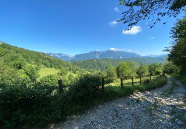
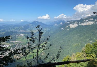
Tocht Stappen van 12,5 km beschikbaar op Auvergne-Rhône-Alpes, Isère, Miribel-les-Échelles. Deze tocht wordt voorgesteld door Phil36.
Beschrijving
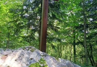
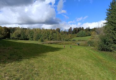
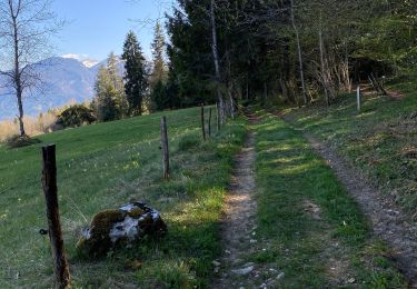
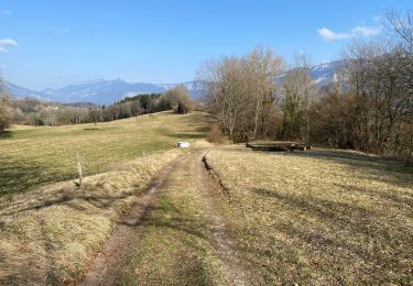
Face à la grande Sure, cette randonnée au relief doux offre un panorama exceptionnel sur la haute Chartreuse à travers prairies et forêts.
Plaatsbepaling
Land:
France
Regio :
Auvergne-Rhône-Alpes
Departement/Provincie :
Isère
Gemeente :
Miribel-les-Échelles
Locatie:
Unknown
Vertrek:(Dec)
Vertrek:(UTM)
711883 ; 5034157 (31T) N.
Opmerkingen
Wandeltochten in de omgeving
![Tocht Stappen Miribel-les-Échelles - mir - Photo](https://media.geolcdn.com/t/375/260/4a726117-d683-49cd-b31a-68e783ca1ce2.jpg&format=jpg&maxdim=2)
![Stappen Stappen](https://static1.geolcdn.com/sitytour/trail-icons/101.png)
mir
Stappen
Moeilijk
Miribel-les-Échelles,
Auvergne-Rhône-Alpes,
Isère,
France
![](/images/other/stat-length.png)
12,7 km | 18 km-effort
7h 23min
![](https://static1.geolcdn.com/siteimages/upload/files/16400158638029165_repeat_loop_refresh_sync_direction_icon.png)
Ja
![Tocht Paardrijden Saint-Aupre - CHA - J3 - 12/09 - St Aupre > La Ruchère - R - Photo](https://media.geolcdn.com/t/375/260/ext.jpg?maxdim=2&url=https%3A%2F%2Fstatic1.geolcdn.com%2Fsiteimages%2Fupload%2Ffiles%2F1524743154cheval.jpg)
![Paardrijden Paardrijden](https://static1.geolcdn.com/sitytour/trail-icons/301.png)
CHA - J3 - 12/09 - St Aupre > La Ruchère - R
Paardrijden
Medium
(1)
Saint-Aupre,
Auvergne-Rhône-Alpes,
Isère,
France
![](/images/other/stat-length.png)
21 km | 37 km-effort
2h 59min
![](https://static1.geolcdn.com/siteimages/upload/files/16400158638029165_repeat_loop_refresh_sync_direction_icon.png)
Neen
![Tocht Paardrijden Saint-Aupre - CHA - J3 - 12/09 - St Aupre > La Ruchère - Photo](https://media.geolcdn.com/t/375/260/ext.jpg?maxdim=2&url=https%3A%2F%2Fstatic1.geolcdn.com%2Fsiteimages%2Fupload%2Ffiles%2F1524743154cheval.jpg)
![Paardrijden Paardrijden](https://static1.geolcdn.com/sitytour/trail-icons/301.png)
CHA - J3 - 12/09 - St Aupre > La Ruchère
Paardrijden
Medium
(1)
Saint-Aupre,
Auvergne-Rhône-Alpes,
Isère,
France
![](/images/other/stat-length.png)
22 km | 40 km-effort
2h 59min
![](https://static1.geolcdn.com/siteimages/upload/files/16400158638029165_repeat_loop_refresh_sync_direction_icon.png)
Neen
![Tocht Stappen Merlas - Merlas boucle par le lac de St Sixt et étang des chartreux - Photo](https://media.geolcdn.com/t/375/260/89c53a81-49aa-496f-a3ef-ba0fc42f890a.jpg&format=jpg&maxdim=2)
![Stappen Stappen](https://static1.geolcdn.com/sitytour/trail-icons/101.png)
Merlas boucle par le lac de St Sixt et étang des chartreux
Stappen
Gemakkelijk
Merlas,
Auvergne-Rhône-Alpes,
Isère,
France
![](/images/other/stat-length.png)
16,6 km | 23 km-effort
4h 30min
![](https://static1.geolcdn.com/siteimages/upload/files/16400158638029165_repeat_loop_refresh_sync_direction_icon.png)
Ja
![Tocht Stappen Miribel-les-Échelles - Circuit panoramique au départ de Miribelle - Photo](https://media.geolcdn.com/t/375/260/b11436e7-f00f-45a9-8670-74fc9f964837.jpg&format=jpg&maxdim=2)
![Stappen Stappen](https://static1.geolcdn.com/sitytour/trail-icons/101.png)
Circuit panoramique au départ de Miribelle
Stappen
Gemakkelijk
(1)
Miribel-les-Échelles,
Auvergne-Rhône-Alpes,
Isère,
France
![](/images/other/stat-length.png)
9,5 km | 13,4 km-effort
2h 57min
![](https://static1.geolcdn.com/siteimages/upload/files/16400158638029165_repeat_loop_refresh_sync_direction_icon.png)
Ja
![Tocht Stappen Saint-Laurent-du-Pont - Le balcon de Saint Laurent - Photo](https://media.geolcdn.com/t/375/260/b9bd2f7b-5bbd-4508-aa19-8047e66c1538.jpg&format=jpg&maxdim=2)
![Stappen Stappen](https://static1.geolcdn.com/sitytour/trail-icons/101.png)
Le balcon de Saint Laurent
Stappen
Gemakkelijk
Saint-Laurent-du-Pont,
Auvergne-Rhône-Alpes,
Isère,
France
![](/images/other/stat-length.png)
8,5 km | 11,5 km-effort
2h 19min
![](https://static1.geolcdn.com/siteimages/upload/files/16400158638029165_repeat_loop_refresh_sync_direction_icon.png)
Ja
![Tocht Stappen Saint-Aupre - Circuit au départ de Saint Aupre - Photo](https://media.geolcdn.com/t/375/260/accbf58a-78f2-4cef-8ae0-2acfb4e853de.jpg&format=jpg&maxdim=2)
![Stappen Stappen](https://static1.geolcdn.com/sitytour/trail-icons/101.png)
Circuit au départ de Saint Aupre
Stappen
Gemakkelijk
Saint-Aupre,
Auvergne-Rhône-Alpes,
Isère,
France
![](/images/other/stat-length.png)
9,7 km | 15,4 km-effort
3h 28min
![](https://static1.geolcdn.com/siteimages/upload/files/16400158638029165_repeat_loop_refresh_sync_direction_icon.png)
Ja
![Tocht Lopen Miribel-les-Échelles - Autour de Miribel-les-echelles - Photo](https://media.geolcdn.com/t/375/260/3c005446-1f23-4fe5-a1eb-5449d2562515.jpg&format=jpg&maxdim=2)
![Lopen Lopen](https://static1.geolcdn.com/sitytour/trail-icons/103.png)
Autour de Miribel-les-echelles
Lopen
Gemakkelijk
Miribel-les-Échelles,
Auvergne-Rhône-Alpes,
Isère,
France
![](/images/other/stat-length.png)
7,2 km | 11,5 km-effort
57min
![](https://static1.geolcdn.com/siteimages/upload/files/16400158638029165_repeat_loop_refresh_sync_direction_icon.png)
Ja
![Tocht Stappen Saint-Laurent-du-Pont - La grande sûre A/R saint Laurent du pont - Photo](https://media.geolcdn.com/t/375/260/3b629f84-afe1-4132-950d-88d4c9437014.jpg&format=jpg&maxdim=2)
![Stappen Stappen](https://static1.geolcdn.com/sitytour/trail-icons/101.png)
La grande sûre A/R saint Laurent du pont
Stappen
Zeer moeilijk
Saint-Laurent-du-Pont,
Auvergne-Rhône-Alpes,
Isère,
France
![](/images/other/stat-length.png)
25 km | 45 km-effort
10h 5min
![](https://static1.geolcdn.com/siteimages/upload/files/16400158638029165_repeat_loop_refresh_sync_direction_icon.png)
Ja