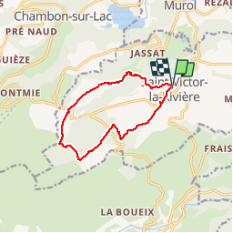
![](/images/other/stat-length.png)
![Tocht Stappen Saint-Victor-la-Rivière - Tour Saint Victor la Riviere - Courbanges - Photo](https://media.geolcdn.com/t/1900/400/ext.pjpeg?maxdim=2&url=https%3A%2F%2Fservices.sitytrail.com%2FGeolivesWS%2FDownloadMedia.ashx%3FTrailID%3D920328%26Media%3Dfix__20180310135536.jpg)
Tour Saint Victor la Riviere - Courbanges
olibreizh
Gebruiker
![Lengte](/images/other/stat-length.png)
![Max. hoogte](https://static1.geolcdn.com/siteimages/upload/files/1508320355ic_sort_altitude_max_24dp.png)
![Positief hoogteverschil](https://static1.geolcdn.com/siteimages/upload/files/1508320355ic_sort_den_pos_24dp.png)
![Km-Effort](/images/other/stat-length.png)
![Min. hoogte](https://static1.geolcdn.com/siteimages/upload/files/1508320355ic_sort_altitude_min_24dp.png)
![Negatief hoogteverschil](https://static1.geolcdn.com/siteimages/upload/files/1508320355ic_sort_den_neg_24dp.png)
![Boucle](https://static1.geolcdn.com/siteimages/upload/files/16400158638029165_repeat_loop_refresh_sync_direction_icon.png)
![Stappen](https://static1.geolcdn.com/sitytour/trail-icons/101.png)
3h18
Moeilijkheid : Medium
![Scan deze QR-code om de tocht te openen in de SityTrail-applicatie](https://capi.geolives.com/qq0zvz2zws4bq2lad0pu/sitytour/trails/920328/qr.png?size=200)
Gratisgps-wandelapplicatie
Over ons
Tocht Stappen van 11,2 km beschikbaar op Auvergne-Rhône-Alpes, Puy-de-Dôme, Saint-Victor-la-Rivière. Deze tocht wordt voorgesteld door olibreizh.
Beschrijving
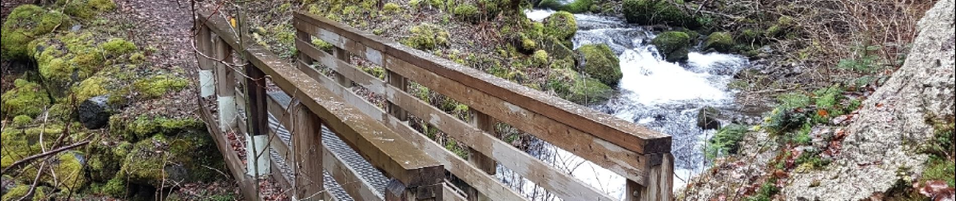
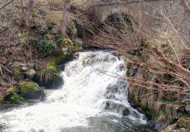
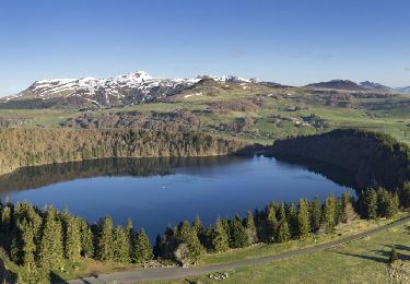
Un Joli tour qui part de Saint Victor la Rivière, qui traverse la forêt de Courbanges par la grande allée jusqu'à rejoindre le GR 30 que l'on suivra jusqu'à Courbanges et le refuge Volcaflore. On suit ensuite le chemin des Quayres que l'on quitte à la Roche des jardins pour rejoindre Saint Victor
Plaatsbepaling
Opmerkingen
Wandeltochten in de omgeving
![Tocht Stappen Besse-et-Saint-Anastaise - Cascades de Chiloza - Photo](https://media.geolcdn.com/t/375/260/7c04b7ff-fd0b-4381-ace8-4f2ed0ec465b.jpg&format=jpg&maxdim=2)
![Stappen Stappen](https://static1.geolcdn.com/sitytour/trail-icons/101.png)
Stappen
![](/images/other/stat-length.png)
![](https://static1.geolcdn.com/siteimages/upload/files/16400158638029165_repeat_loop_refresh_sync_direction_icon.png)
![Tocht Stappen Chambon-sur-Lac - Chambon_Couze_Surains - Photo](https://media.geolcdn.com/t/375/260/69ddf9d1-6553-4ac4-9be3-6827620eb27f.jpg&format=jpg&maxdim=2)
![Stappen Stappen](https://static1.geolcdn.com/sitytour/trail-icons/101.png)
Stappen
![](/images/other/stat-length.png)
![](https://static1.geolcdn.com/siteimages/upload/files/16400158638029165_repeat_loop_refresh_sync_direction_icon.png)
![Tocht Stappen Besse-et-Saint-Anastaise - Besse_Couze_Pavin_1 - Photo](https://media.geolcdn.com/t/375/260/103ff33f-1fd8-4c46-a178-5c713f741cc1.jpg&format=jpg&maxdim=2)
![Stappen Stappen](https://static1.geolcdn.com/sitytour/trail-icons/101.png)
Stappen
![](/images/other/stat-length.png)
![](https://static1.geolcdn.com/siteimages/upload/files/16400158638029165_repeat_loop_refresh_sync_direction_icon.png)
![Tocht Stappen Saint-Victor-la-Rivière - St_Victor_Foret_Courbanges - Photo](https://media.geolcdn.com/t/375/260/9fef1c83-9b6e-46fe-9ede-9513f0c587d7.jpg&format=jpg&maxdim=2)
![Stappen Stappen](https://static1.geolcdn.com/sitytour/trail-icons/101.png)
Stappen
![](/images/other/stat-length.png)
![](https://static1.geolcdn.com/siteimages/upload/files/16400158638029165_repeat_loop_refresh_sync_direction_icon.png)
![Tocht Stappen Murol - Lac Chambon et château médiéval de Murol - Photo](https://media.geolcdn.com/t/375/260/ext.jpg?maxdim=2&url=https%3A%2F%2Fservices.sitytrail.com%2FGeolivesWS%2FDownloadMedia.ashx%3FTrailID%3D103434%26Media%3D5550_4.jpg)
![Stappen Stappen](https://static1.geolcdn.com/sitytour/trail-icons/101.png)
Stappen
![](/images/other/stat-length.png)
![](https://static1.geolcdn.com/siteimages/upload/files/16400158638029165_repeat_loop_refresh_sync_direction_icon.png)
![Tocht Stappen Murol - Murol_Marais_Chambon - Photo](https://media.geolcdn.com/t/375/260/0f7a243a-9f85-491b-8248-bb99ca309e11.jpg&format=jpg&maxdim=2)
![Stappen Stappen](https://static1.geolcdn.com/sitytour/trail-icons/101.png)
Stappen
![](/images/other/stat-length.png)
![](https://static1.geolcdn.com/siteimages/upload/files/16400158638029165_repeat_loop_refresh_sync_direction_icon.png)
![Tocht Stappen Chambon-sur-Lac - Chambon_Moneaux - Photo](https://media.geolcdn.com/t/375/260/460725f3-6d73-441e-a5c8-44b8d6b3875e.jpg&format=jpg&maxdim=2)
![Stappen Stappen](https://static1.geolcdn.com/sitytour/trail-icons/101.png)
Stappen
![](/images/other/stat-length.png)
![](https://static1.geolcdn.com/siteimages/upload/files/16400158638029165_repeat_loop_refresh_sync_direction_icon.png)
![Tocht Mountainbike Besse-et-Saint-Anastaise - Espace VTT FFC du Sancy - Circuit n°30 - Tour des Lacs - Secteur Besse - Photo](https://media.geolcdn.com/t/375/260/ext.jpg?maxdim=2&url=https%3A%2F%2Fservices.sitytrail.com%2FGeolivesWS%2FDownloadMedia.ashx%3FTrailID%3D172888%26Media%3D14346_2.jpg)
![Mountainbike Mountainbike](https://static1.geolcdn.com/sitytour/trail-icons/202.png)
Mountainbike
![](/images/other/stat-length.png)
![](https://static1.geolcdn.com/siteimages/upload/files/16400158638029165_repeat_loop_refresh_sync_direction_icon.png)
![Tocht Stappen Besse-et-Saint-Anastaise - Les cascades de Chiloza - Photo](https://media.geolcdn.com/t/375/260/ext.jpg?maxdim=2&url=https%3A%2F%2Fservices.sitytrail.com%2FGeolivesWS%2FDownloadMedia.ashx%3FTrailID%3D149215%26Media%3D20120822161328.jpeg)
![Stappen Stappen](https://static1.geolcdn.com/sitytour/trail-icons/101.png)
Stappen
![](/images/other/stat-length.png)
![](https://static1.geolcdn.com/siteimages/upload/files/16400158638029165_repeat_loop_refresh_sync_direction_icon.png)