![](/images/other/stat-length.png)
![Tocht Stappen Stoumont - La Venne 1 - Photo](https://media.geolcdn.com/t/1900/400/ext.pjpeg?maxdim=2&url=https%3A%2F%2Fstatic1.geolcdn.com%2Fsiteimages%2Fupload%2Ffiles%2F1553511878bg_sport_marche.png)
La Venne 1
NickPluym
Gebruiker
![Lengte](/images/other/stat-length.png)
Lengte
7,2 km
![Max. hoogte](https://static1.geolcdn.com/siteimages/upload/files/1508320355ic_sort_altitude_max_24dp.png)
Max. hoogte
412 m
![Positief hoogteverschil](https://static1.geolcdn.com/siteimages/upload/files/1508320355ic_sort_den_pos_24dp.png)
Positief hoogteverschil
252 m
![Km-Effort](/images/other/stat-length.png)
Km-Effort
10,5 km
![Min. hoogte](https://static1.geolcdn.com/siteimages/upload/files/1508320355ic_sort_altitude_min_24dp.png)
Min. hoogte
211 m
![Negatief hoogteverschil](https://static1.geolcdn.com/siteimages/upload/files/1508320355ic_sort_den_neg_24dp.png)
Negatief hoogteverschil
249 m
![Boucle](https://static1.geolcdn.com/siteimages/upload/files/16400158638029165_repeat_loop_refresh_sync_direction_icon.png)
Boucle
Ja
Datum van aanmaak :
2018-04-17 18:41:44.597
Laatste wijziging :
2018-04-17 18:41:44.597
![Stappen](https://static1.geolcdn.com/sitytour/trail-icons/101.png)
2h30
Moeilijkheid : Medium
![Scan deze QR-code om de tocht te openen in de SityTrail-applicatie](https://capi.geolives.com/qq0zvz2zws4bq2lad0pu/sitytour/trails/904814/qr.png?size=200)
Gratisgps-wandelapplicatie
Over ons
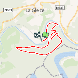
Tocht Stappen van 7,2 km beschikbaar op Wallonië, Luik, Stoumont. Deze tocht wordt voorgesteld door NickPluym.
Beschrijving
Een tourtje naar het wildpark waar je de witte wolven kan bewonderen, daarna een spectaculaire afdaling over een everzwijnen pad, te doen met sportieve kinderen vanaf 8 jaar. (Afkorting mogelijk)
Plaatsbepaling
Land:
Belgium
Regio :
Wallonië
Departement/Provincie :
Luik
Gemeente :
Stoumont
Locatie:
La Gleize
Vertrek:(Dec)
Vertrek:(UTM)
702531 ; 5586966 (31U) N.
Opmerkingen
Wandeltochten in de omgeving
![Tocht Stappen Trois-Ponts - RB-Lg-27_Trois-Ponts - Photo](https://media.geolcdn.com/t/375/260/ext.jpg?maxdim=2&url=https%3A%2F%2Fservices.sitytrail.com%2FGeolivesWS%2FDownloadMedia.ashx%3FTrailID%3D402090%26Media%3Ddb9e80d9-8efc-4045-abb6-cee4f6885ea2.jpg)
![Stappen Stappen](https://static1.geolcdn.com/sitytour/trail-icons/101.png)
RB-Lg-27_Trois-Ponts
Stappen
(7)
Trois-Ponts,
Wallonië,
Luik,
Belgium
![](/images/other/stat-length.png)
23 km | 33 km-effort
7h 30min
![](https://static1.geolcdn.com/siteimages/upload/files/16400158638029165_repeat_loop_refresh_sync_direction_icon.png)
Ja
![Tocht Stappen Stoumont - RB-LG-13 - Par monts et par vaux autour de Stoumont - Photo](https://media.geolcdn.com/t/375/260/ext.jpg?maxdim=2&url=https%3A%2F%2Fservices.sitytrail.com%2FGeolivesWS%2FDownloadMedia.ashx%3FTrailID%3D179571%26Media%3Dfca3b0ca-06fe-45d6-8ded-857ea27270cf.jpg)
![Stappen Stappen](https://static1.geolcdn.com/sitytour/trail-icons/101.png)
RB-LG-13 - Par monts et par vaux autour de Stoumont
Stappen
Zeer moeilijk
(11)
Stoumont,
Wallonië,
Luik,
Belgium
![](/images/other/stat-length.png)
23 km | 32 km-effort
7h 19min
![](https://static1.geolcdn.com/siteimages/upload/files/16400158638029165_repeat_loop_refresh_sync_direction_icon.png)
Ja
![Tocht Stappen Stoumont - 2022-02-03_17h52m52_StoumontP14PromenadedessommetsdelaLienne - Photo](https://media.geolcdn.com/t/375/260/a2987c7f-4dfa-4904-87e7-be0c835ea8dd.jpg&format=jpg&maxdim=2)
![Stappen Stappen](https://static1.geolcdn.com/sitytour/trail-icons/101.png)
2022-02-03_17h52m52_StoumontP14PromenadedessommetsdelaLienne
Stappen
Medium
(2)
Stoumont,
Wallonië,
Luik,
Belgium
![](/images/other/stat-length.png)
16,1 km | 23 km-effort
5h 11min
![](https://static1.geolcdn.com/siteimages/upload/files/16400158638029165_repeat_loop_refresh_sync_direction_icon.png)
Ja
![Tocht Stappen Stoumont - 2021-03-12_16h39m43_LaGleizeP3TourduMontSaintVictor - Photo](https://media.geolcdn.com/t/375/260/eeda461f-0b98-4912-915c-63b0e2025382.jpg&format=jpg&maxdim=2)
![Stappen Stappen](https://static1.geolcdn.com/sitytour/trail-icons/101.png)
2021-03-12_16h39m43_LaGleizeP3TourduMontSaintVictor
Stappen
Medium
(3)
Stoumont,
Wallonië,
Luik,
Belgium
![](/images/other/stat-length.png)
15,8 km | 22 km-effort
5h 2min
![](https://static1.geolcdn.com/siteimages/upload/files/16400158638029165_repeat_loop_refresh_sync_direction_icon.png)
Ja
![Tocht Stappen Stavelot - 2021-03-10_14h59m08_1227 - Photo](https://media.geolcdn.com/t/375/260/8b34c446-55a9-478c-88d7-9cb986b390fb.jpg&format=jpg&maxdim=2)
![Stappen Stappen](https://static1.geolcdn.com/sitytour/trail-icons/101.png)
2021-03-10_14h59m08_1227
Stappen
Moeilijk
(3)
Stavelot,
Wallonië,
Luik,
Belgium
![](/images/other/stat-length.png)
18,8 km | 26 km-effort
5h 53min
![](https://static1.geolcdn.com/siteimages/upload/files/16400158638029165_repeat_loop_refresh_sync_direction_icon.png)
Neen
![Tocht Stappen Trois-Ponts - RB-Lg-27_Trois-Ponts_via-racc - Photo](https://media.geolcdn.com/t/375/260/ext.jpg?maxdim=2&url=https%3A%2F%2Fservices.sitytrail.com%2FGeolivesWS%2FDownloadMedia.ashx%3FTrailID%3D402091%26Media%3Ddb9e80d9-8efc-4045-abb6-cee4f6885ea2.jpg)
![Stappen Stappen](https://static1.geolcdn.com/sitytour/trail-icons/101.png)
RB-Lg-27_Trois-Ponts_via-racc
Stappen
Zeer moeilijk
(1)
Trois-Ponts,
Wallonië,
Luik,
Belgium
![](/images/other/stat-length.png)
16,9 km | 25 km-effort
5h 36min
![](https://static1.geolcdn.com/siteimages/upload/files/16400158638029165_repeat_loop_refresh_sync_direction_icon.png)
Ja
![Tocht Stappen Stoumont - stoumont . corniche - congo . chateau froidcourt . ambleve . stoumont - Photo](https://media.geolcdn.com/t/375/260/e9a69a2e-c189-4076-b755-49e5203b8455.jpg&format=jpg&maxdim=2)
![Stappen Stappen](https://static1.geolcdn.com/sitytour/trail-icons/101.png)
stoumont . corniche - congo . chateau froidcourt . ambleve . stoumont
Stappen
Heel gemakkelijk
(1)
Stoumont,
Wallonië,
Luik,
Belgium
![](/images/other/stat-length.png)
9,1 km | 12,1 km-effort
2h 44min
![](https://static1.geolcdn.com/siteimages/upload/files/16400158638029165_repeat_loop_refresh_sync_direction_icon.png)
Ja
![Tocht Stappen Theux - petit tour à Bronromme - Photo](https://media.geolcdn.com/t/375/260/3bde52fd-19d7-4e01-be15-97a6eaa8c76d.jpg&format=jpg&maxdim=2)
![Stappen Stappen](https://static1.geolcdn.com/sitytour/trail-icons/101.png)
petit tour à Bronromme
Stappen
Heel gemakkelijk
(1)
Theux,
Wallonië,
Luik,
Belgium
![](/images/other/stat-length.png)
7,6 km | 9,1 km-effort
1h 53min
![](https://static1.geolcdn.com/siteimages/upload/files/16400158638029165_repeat_loop_refresh_sync_direction_icon.png)
Ja
![Tocht Stappen Stoumont - RB-Lg-13-BC-2019_Rac - Photo](https://media.geolcdn.com/t/375/260/ext.jpg?maxdim=2&url=https%3A%2F%2Fservices.sitytrail.com%2FGeolivesWS%2FDownloadMedia.ashx%3FTrailID%3D179572%26Media%3Ddd649bf1-a115-4c1e-9e23-c1a80ab51103.jpg)
![Stappen Stappen](https://static1.geolcdn.com/sitytour/trail-icons/101.png)
RB-Lg-13-BC-2019_Rac
Stappen
Zeer moeilijk
(3)
Stoumont,
Wallonië,
Luik,
Belgium
![](/images/other/stat-length.png)
17,6 km | 24 km-effort
5h 25min
![](https://static1.geolcdn.com/siteimages/upload/files/16400158638029165_repeat_loop_refresh_sync_direction_icon.png)
Ja
Généralement bons chemins, sauf la descente raide dont le chemin n'est pas référencé sur les cartes: suivre les traces de VTT et à la fin prendre à gauche du gros rocher pour atteindre le chemin de la carte: facile si on suit la trace de la balade. Passage le long de la cloture de la réserve animalière de Coo (biches, cerf, dingo). de très belles vues sur la vallée de l'Amblève (Stoumont-La Gleize). Possibilité d'allonger et d'aller jusque Coo