![](/images/other/stat-length.png)
![Tocht Sneeuwschoenen Bareilles - Bareilles Raquettes - Photo](https://media.geolcdn.com/t/1900/400/ext.pjpeg?maxdim=2&url=https%3A%2F%2Fstatic1.geolcdn.com%2Fsiteimages%2Fupload%2Ffiles%2F1524743153raquette.jpg)
Bareilles Raquettes
JACQUOU
Gebruiker
![Lengte](/images/other/stat-length.png)
Lengte
12,2 km
![Max. hoogte](https://static1.geolcdn.com/siteimages/upload/files/1508320355ic_sort_altitude_max_24dp.png)
Max. hoogte
1729 m
![Positief hoogteverschil](https://static1.geolcdn.com/siteimages/upload/files/1508320355ic_sort_den_pos_24dp.png)
Positief hoogteverschil
721 m
![Km-Effort](/images/other/stat-length.png)
Km-Effort
22 km
![Min. hoogte](https://static1.geolcdn.com/siteimages/upload/files/1508320355ic_sort_altitude_min_24dp.png)
Min. hoogte
1059 m
![Negatief hoogteverschil](https://static1.geolcdn.com/siteimages/upload/files/1508320355ic_sort_den_neg_24dp.png)
Negatief hoogteverschil
721 m
![Boucle](https://static1.geolcdn.com/siteimages/upload/files/16400158638029165_repeat_loop_refresh_sync_direction_icon.png)
Boucle
Ja
Datum van aanmaak :
2018-04-17 17:37:08.425
Laatste wijziging :
2018-04-17 17:37:08.425
![Sneeuwschoenen](https://static1.geolcdn.com/sitytour/trail-icons/504.png)
4h34
Moeilijkheid : Medium
![Scan deze QR-code om de tocht te openen in de SityTrail-applicatie](https://capi.geolives.com/qq0zvz2zws4bq2lad0pu/sitytour/trails/897494/qr.png?size=200)
Gratisgps-wandelapplicatie
Over ons
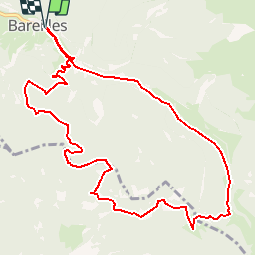
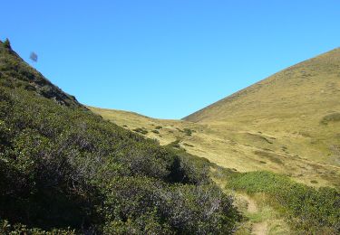
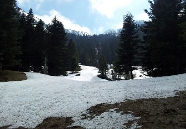
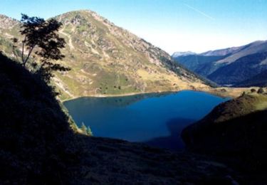
Tocht Sneeuwschoenen van 12,2 km beschikbaar op Occitanië, Hautes-Pyrénées, Bareilles. Deze tocht wordt voorgesteld door JACQUOU.
Beschrijving
Randonnée raquettes en passant Sapinière de Coudous;chemin du lac;Cabane d'Arrieu Tort;Cabane et retour par le chemin de Sarradaus et chemin de Ristout
Plaatsbepaling
Land:
France
Regio :
Occitanië
Departement/Provincie :
Hautes-Pyrénées
Gemeente :
Bareilles
Locatie:
Unknown
Vertrek:(Dec)
Vertrek:(UTM)
289772 ; 4752511 (31T) N.
Opmerkingen
Wandeltochten in de omgeving
![Tocht Stappen Bourg-d'Oueil - Sommet du Tech et Pic du Lion - Photo](https://media.geolcdn.com/t/375/260/ext.jpg?maxdim=2&url=https%3A%2F%2Fservices.sitytrail.com%2FGeolivesWS%2FDownloadMedia.ashx%3FTrailID%3D108803%26Media%3D2124_6.jpg)
![Stappen Stappen](https://static1.geolcdn.com/sitytour/trail-icons/101.png)
Sommet du Tech et Pic du Lion
Stappen
Moeilijk
(1)
Bourg-d'Oueil,
Occitanië,
Haute-Garonne,
France
![](/images/other/stat-length.png)
7,1 km | 13,3 km-effort
4h 4min
![](https://static1.geolcdn.com/siteimages/upload/files/16400158638029165_repeat_loop_refresh_sync_direction_icon.png)
Ja
![Tocht Stappen Lançon - Lanson - Photo](https://media.geolcdn.com/t/375/260/583a7f79-a87a-4d27-8293-15d5a8c0cb3a.jpg&format=jpg&maxdim=2)
![Stappen Stappen](https://static1.geolcdn.com/sitytour/trail-icons/101.png)
Lanson
Stappen
Gemakkelijk
Lançon,
Occitanië,
Hautes-Pyrénées,
France
![](/images/other/stat-length.png)
7 km | 11 km-effort
2h 20min
![](https://static1.geolcdn.com/siteimages/upload/files/16400158638029165_repeat_loop_refresh_sync_direction_icon.png)
Ja
![Tocht Stappen Ferrère - montagne d'Areng depuis la piste forestière après Férrères - Photo](https://media.geolcdn.com/t/375/260/b26d10b6-49f2-42a6-bd0e-42b976ea8679.jpg&format=jpg&maxdim=2)
![Stappen Stappen](https://static1.geolcdn.com/sitytour/trail-icons/101.png)
montagne d'Areng depuis la piste forestière après Férrères
Stappen
Moeilijk
Ferrère,
Occitanië,
Hautes-Pyrénées,
France
![](/images/other/stat-length.png)
11,7 km | 24 km-effort
7h 44min
![](https://static1.geolcdn.com/siteimages/upload/files/16400158638029165_repeat_loop_refresh_sync_direction_icon.png)
Ja
![Tocht Te voet Bordères-Louron - Lac de Bareilles et Mont Né - Photo](https://media.geolcdn.com/t/375/260/7d524aea-9fca-43bb-898b-ff4e94703e2f.jpeg&format=jpg&maxdim=2)
![Te voet Te voet](https://static1.geolcdn.com/sitytour/trail-icons/100.png)
Lac de Bareilles et Mont Né
Te voet
Gemakkelijk
Bordères-Louron,
Occitanië,
Hautes-Pyrénées,
France
![](/images/other/stat-length.png)
3,8 km | 8,2 km-effort
1h 51min
![](https://static1.geolcdn.com/siteimages/upload/files/16400158638029165_repeat_loop_refresh_sync_direction_icon.png)
Neen
![Tocht Stappen Bareilles - Lac de Bareilles - Photo](https://media.geolcdn.com/t/375/260/ext.jpg?maxdim=2&url=https%3A%2F%2Fservices.sitytrail.com%2FGeolivesWS%2FDownloadMedia.ashx%3FTrailID%3D268170%26Media%3Dfix__20140419161621.jpg)
![Stappen Stappen](https://static1.geolcdn.com/sitytour/trail-icons/101.png)
Lac de Bareilles
Stappen
Medium
Bareilles,
Occitanië,
Hautes-Pyrénées,
France
![](/images/other/stat-length.png)
13,4 km | 24 km-effort
7h 15min
![](https://static1.geolcdn.com/siteimages/upload/files/16400158638029165_repeat_loop_refresh_sync_direction_icon.png)
Ja
![Tocht Stappen Bordères-Louron - Borderes-Louron <> Cazeaux - Photo](https://media.geolcdn.com/t/375/260/90e3d1ea-5bf2-4a9b-89ee-84ed0a38222d.jpg&format=jpg&maxdim=2)
![Stappen Stappen](https://static1.geolcdn.com/sitytour/trail-icons/101.png)
Borderes-Louron <> Cazeaux
Stappen
Medium
Bordères-Louron,
Occitanië,
Hautes-Pyrénées,
France
![](/images/other/stat-length.png)
12,3 km | 21 km-effort
4h 9min
![](https://static1.geolcdn.com/siteimages/upload/files/16400158638029165_repeat_loop_refresh_sync_direction_icon.png)
Ja
![Tocht Stappen Ferrère - cap Nesté depuis la Barousse - Photo](https://media.geolcdn.com/t/375/260/ext.jpg?maxdim=2&url=https%3A%2F%2Fstatic1.geolcdn.com%2Fsiteimages%2Fupload%2Ffiles%2F1553511878bg_sport_marche.png)
![Stappen Stappen](https://static1.geolcdn.com/sitytour/trail-icons/101.png)
cap Nesté depuis la Barousse
Stappen
Medium
Ferrère,
Occitanië,
Hautes-Pyrénées,
France
![](/images/other/stat-length.png)
9,2 km | 19,3 km-effort
6h 46min
![](https://static1.geolcdn.com/siteimages/upload/files/16400158638029165_repeat_loop_refresh_sync_direction_icon.png)
Ja
![Tocht Stappen Bordères-Louron - Bois de la Pale - Vallée du Louron - Photo](https://media.geolcdn.com/t/375/260/ext.jpg?maxdim=2&url=https%3A%2F%2Fservices.sitytrail.com%2FGeolivesWS%2FDownloadMedia.ashx%3FTrailID%3D102506%26Media%3D3315_1.jpg)
![Stappen Stappen](https://static1.geolcdn.com/sitytour/trail-icons/101.png)
Bois de la Pale - Vallée du Louron
Stappen
Medium
Bordères-Louron,
Occitanië,
Hautes-Pyrénées,
France
![](/images/other/stat-length.png)
10 km | 18 km-effort
2h 30min
![](https://static1.geolcdn.com/siteimages/upload/files/16400158638029165_repeat_loop_refresh_sync_direction_icon.png)
Ja
![Tocht Stappen Bareilles - Pic du Lion - Photo](https://media.geolcdn.com/t/375/260/ext.jpg?maxdim=2&url=https%3A%2F%2Fservices.sitytrail.com%2FGeolivesWS%2FDownloadMedia.ashx%3FTrailID%3D101265%26Media%3D752_1.jpg)
![Stappen Stappen](https://static1.geolcdn.com/sitytour/trail-icons/101.png)
Pic du Lion
Stappen
Medium
Bareilles,
Occitanië,
Hautes-Pyrénées,
France
![](/images/other/stat-length.png)
8,2 km | 16,9 km-effort
4h 0min
![](https://static1.geolcdn.com/siteimages/upload/files/16400158638029165_repeat_loop_refresh_sync_direction_icon.png)
Ja