![](/images/other/stat-length.png)
![Tocht Stappen Montagagne - Cap de Carmil - Photo](https://media.geolcdn.com/t/1900/400/008312c9-da59-4fe8-824c-61eee5176bdc.jpg&format=pjpeg&maxdim=2)
Cap de Carmil
philou6351
Gebruiker
![Lengte](/images/other/stat-length.png)
Lengte
11,7 km
![Max. hoogte](https://static1.geolcdn.com/siteimages/upload/files/1508320355ic_sort_altitude_max_24dp.png)
Max. hoogte
1617 m
![Positief hoogteverschil](https://static1.geolcdn.com/siteimages/upload/files/1508320355ic_sort_den_pos_24dp.png)
Positief hoogteverschil
539 m
![Km-Effort](/images/other/stat-length.png)
Km-Effort
18,9 km
![Min. hoogte](https://static1.geolcdn.com/siteimages/upload/files/1508320355ic_sort_altitude_min_24dp.png)
Min. hoogte
1254 m
![Negatief hoogteverschil](https://static1.geolcdn.com/siteimages/upload/files/1508320355ic_sort_den_neg_24dp.png)
Negatief hoogteverschil
540 m
![Boucle](https://static1.geolcdn.com/siteimages/upload/files/16400158638029165_repeat_loop_refresh_sync_direction_icon.png)
Boucle
Ja
Datum van aanmaak :
2018-04-17 16:12:23.577
Laatste wijziging :
2018-08-25 13:29:51.509
![Stappen](https://static1.geolcdn.com/sitytour/trail-icons/101.png)
3h59
Moeilijkheid : Onbekend
![Scan deze QR-code om de tocht te openen in de SityTrail-applicatie](https://capi.geolives.com/qq0zvz2zws4bq2lad0pu/sitytour/trails/887664/qr.png?size=200)
Gratisgps-wandelapplicatie
Over ons
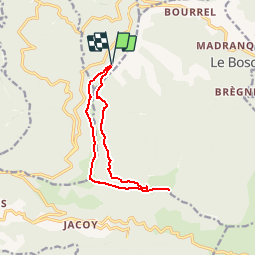
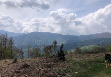
Tocht Stappen van 11,7 km beschikbaar op Occitanië, Ariège, Montagagne. Deze tocht wordt voorgesteld door philou6351.
Beschrijving
Acces:
De Foix, emprunter la D17
Vous passerez le col des Marrous, puis juste avant d'arriver au col de Jouels, prendre à gauche la D111
Vous rejoignez rapidement le col d'Uscla, point de départ de la randonnée.
Plaatsbepaling
Land:
France
Regio :
Occitanië
Departement/Provincie :
Ariège
Gemeente :
Montagagne
Locatie:
Unknown
Vertrek:(Dec)
Vertrek:(UTM)
370941 ; 4756084 (31T) N.
Opmerkingen
Wandeltochten in de omgeving
![Tocht Stappen Le Bosc - Le Planel depuis le Col des Marrous - Photo](https://media.geolcdn.com/t/375/260/ext.jpg?maxdim=2&url=https%3A%2F%2Fservices.sitytrail.com%2FGeolivesWS%2FDownloadMedia.ashx%3FTrailID%3D110331%26Media%3D5772_1.jpg)
![Stappen Stappen](https://static1.geolcdn.com/sitytour/trail-icons/101.png)
Le Planel depuis le Col des Marrous
Stappen
Medium
(1)
Le Bosc,
Occitanië,
Ariège,
France
![](/images/other/stat-length.png)
6,7 km | 9,1 km-effort
2h 25min
![](https://static1.geolcdn.com/siteimages/upload/files/16400158638029165_repeat_loop_refresh_sync_direction_icon.png)
Ja
![Tocht Stappen Le Bosc - Le Cap du Carmil depuis le Col des Marrous - Photo](https://media.geolcdn.com/t/375/260/ext.jpg?maxdim=2&url=https%3A%2F%2Fservices.sitytrail.com%2FGeolivesWS%2FDownloadMedia.ashx%3FTrailID%3D109453%26Media%3D3908_5.jpg)
![Stappen Stappen](https://static1.geolcdn.com/sitytour/trail-icons/101.png)
Le Cap du Carmil depuis le Col des Marrous
Stappen
Moeilijk
Le Bosc,
Occitanië,
Ariège,
France
![](/images/other/stat-length.png)
14,6 km | 24 km-effort
6h 10min
![](https://static1.geolcdn.com/siteimages/upload/files/16400158638029165_repeat_loop_refresh_sync_direction_icon.png)
Ja
![Tocht Wintersport Le Bosc - Boucle Col des Marrous - Photo](https://media.geolcdn.com/t/375/260/ext.jpg?maxdim=2&url=https%3A%2F%2Fstatic1.geolcdn.com%2Fsiteimages%2Fupload%2Ffiles%2F1524743153ski.jpg)
![Wintersport Wintersport](https://static1.geolcdn.com/sitytour/trail-icons/500.png)
Boucle Col des Marrous
Wintersport
Medium
(1)
Le Bosc,
Occitanië,
Ariège,
France
![](/images/other/stat-length.png)
8,5 km | 13 km-effort
1h 8min
![](https://static1.geolcdn.com/siteimages/upload/files/16400158638029165_repeat_loop_refresh_sync_direction_icon.png)
Ja
![Tocht Stappen Montagagne - Col d’Uscla -boucle vers col des Marrous - Photo](https://media.geolcdn.com/t/375/260/48b0d083-6da5-40c5-a477-84bb38f8e859.jpg&format=jpg&maxdim=2)
![Stappen Stappen](https://static1.geolcdn.com/sitytour/trail-icons/101.png)
Col d’Uscla -boucle vers col des Marrous
Stappen
Medium
Montagagne,
Occitanië,
Ariège,
France
![](/images/other/stat-length.png)
5 km | 7,8 km-effort
1h 18min
![](https://static1.geolcdn.com/siteimages/upload/files/16400158638029165_repeat_loop_refresh_sync_direction_icon.png)
Ja
![Tocht Paard Alzen - Boucle dans le Massif de l'Arize - Col des Marrous - Nescus - Photo](https://media.geolcdn.com/t/375/260/ext.jpg?maxdim=2&url=https%3A%2F%2Fservices.sitytrail.com%2FGeolivesWS%2FDownloadMedia.ashx%3FTrailID%3D108221%26Media%3D859_1.jpg)
![Paard Paard](https://static1.geolcdn.com/sitytour/trail-icons/300.png)
Boucle dans le Massif de l'Arize - Col des Marrous - Nescus
Paard
Medium
Alzen,
Occitanië,
Ariège,
France
![](/images/other/stat-length.png)
7 km | 10 km-effort
1h 0min
![](https://static1.geolcdn.com/siteimages/upload/files/16400158638029165_repeat_loop_refresh_sync_direction_icon.png)
Neen
![Tocht Paard Sentenac-de-Sérou - Boucle dans le Massif de l'Arize - Cap du Carmil - Col des Marrous - Photo](https://media.geolcdn.com/t/375/260/ext.jpg?maxdim=2&url=https%3A%2F%2Fservices.sitytrail.com%2FGeolivesWS%2FDownloadMedia.ashx%3FTrailID%3D108220%26Media%3D858_1.jpg)
![Paard Paard](https://static1.geolcdn.com/sitytour/trail-icons/300.png)
Boucle dans le Massif de l'Arize - Cap du Carmil - Col des Marrous
Paard
Medium
Sentenac-de-Sérou,
Occitanië,
Ariège,
France
![](/images/other/stat-length.png)
7,7 km | 9,9 km-effort
1h 30min
![](https://static1.geolcdn.com/siteimages/upload/files/16400158638029165_repeat_loop_refresh_sync_direction_icon.png)
Neen
![Tocht Stappen Montagagne - Cap de Carmil - Col de Péguère - Photo](https://media.geolcdn.com/t/375/260/ext.jpg?maxdim=2&url=https%3A%2F%2Fservices.sitytrail.com%2FGeolivesWS%2FDownloadMedia.ashx%3FTrailID%3D104794%26Media%3D8264_2.jpg)
![Stappen Stappen](https://static1.geolcdn.com/sitytour/trail-icons/101.png)
Cap de Carmil - Col de Péguère
Stappen
Medium
Montagagne,
Occitanië,
Ariège,
France
![](/images/other/stat-length.png)
11,1 km | 17,6 km-effort
4h 0min
![](https://static1.geolcdn.com/siteimages/upload/files/16400158638029165_repeat_loop_refresh_sync_direction_icon.png)
Ja
![Tocht Te voet Burret - Tour du moulin - Photo](https://media.geolcdn.com/t/375/260/ext.jpg?maxdim=2&url=https%3A%2F%2Fstatic1.geolcdn.com%2Fsiteimages%2Fupload%2Ffiles%2F1545311037marcheuse_200dpi.jpg)
![Te voet Te voet](https://static1.geolcdn.com/sitytour/trail-icons/100.png)
Tour du moulin
Te voet
Gemakkelijk
Burret,
Occitanië,
Ariège,
France
![](/images/other/stat-length.png)
8 km | 12,7 km-effort
2h 53min
![](https://static1.geolcdn.com/siteimages/upload/files/16400158638029165_repeat_loop_refresh_sync_direction_icon.png)
Ja
![Tocht Stappen Le Bosc - cap carmil - Photo](https://media.geolcdn.com/t/375/260/ext.jpg?maxdim=2&url=https%3A%2F%2Fstatic1.geolcdn.com%2Fsiteimages%2Fupload%2Ffiles%2F1553511878bg_sport_marche.png)
![Stappen Stappen](https://static1.geolcdn.com/sitytour/trail-icons/101.png)
cap carmil
Stappen
Gemakkelijk
Le Bosc,
Occitanië,
Ariège,
France
![](/images/other/stat-length.png)
13,4 km | 22 km-effort
4h 23min
![](https://static1.geolcdn.com/siteimages/upload/files/16400158638029165_repeat_loop_refresh_sync_direction_icon.png)
Ja