![](/images/other/stat-length.png)
![Tocht Stappen Saint-Philbert-de-Grand-Lieu - Saint-Philbert-de-Grand-Lieu - Les Vignes - Photo](https://media.geolcdn.com/t/1900/400/ext.pjpeg?maxdim=2&url=https%3A%2F%2Fstatic1.geolcdn.com%2Fsiteimages%2Fupload%2Ffiles%2F1553511878bg_sport_marche.png)
Saint-Philbert-de-Grand-Lieu - Les Vignes
TEFFRA
Gebruiker
![Lengte](/images/other/stat-length.png)
Lengte
8,6 km
![Max. hoogte](https://static1.geolcdn.com/siteimages/upload/files/1508320355ic_sort_altitude_max_24dp.png)
Max. hoogte
52 m
![Positief hoogteverschil](https://static1.geolcdn.com/siteimages/upload/files/1508320355ic_sort_den_pos_24dp.png)
Positief hoogteverschil
53 m
![Km-Effort](/images/other/stat-length.png)
Km-Effort
9,3 km
![Min. hoogte](https://static1.geolcdn.com/siteimages/upload/files/1508320355ic_sort_altitude_min_24dp.png)
Min. hoogte
30 m
![Negatief hoogteverschil](https://static1.geolcdn.com/siteimages/upload/files/1508320355ic_sort_den_neg_24dp.png)
Negatief hoogteverschil
53 m
![Boucle](https://static1.geolcdn.com/siteimages/upload/files/16400158638029165_repeat_loop_refresh_sync_direction_icon.png)
Boucle
Ja
Datum van aanmaak :
2018-04-17 14:42:14.606
Laatste wijziging :
2018-04-17 14:42:14.606
![Stappen](https://static1.geolcdn.com/sitytour/trail-icons/101.png)
2h04
Moeilijkheid : Medium
![Scan deze QR-code om de tocht te openen in de SityTrail-applicatie](https://capi.geolives.com/qq0zvz2zws4bq2lad0pu/sitytour/trails/876315/qr.png?size=200)
Gratisgps-wandelapplicatie
Over ons
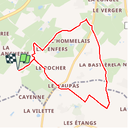
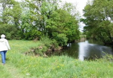
Tocht Stappen van 8,6 km beschikbaar op Pays de la Loire, Loire-Atlantique, Saint-Philbert-de-Grand-Lieu. Deze tocht wordt voorgesteld door TEFFRA.
Beschrijving
Point de RDV parking village de la Révellerie - D61 Saint-Colomban / D861 à droite / après Roche Blanche à gauche
Plaatsbepaling
Land:
France
Regio :
Pays de la Loire
Departement/Provincie :
Loire-Atlantique
Gemeente :
Saint-Philbert-de-Grand-Lieu
Locatie:
Unknown
Vertrek:(Dec)
Vertrek:(UTM)
601000 ; 5207251 (30T) N.
Opmerkingen
Wandeltochten in de omgeving
![Tocht Te voet Saint-Philbert-de-Grand-Lieu - Déas - Photo](https://media.geolcdn.com/t/375/260/a96fc121-0120-4641-91f8-e4eb1d42229f.jpeg&format=jpg&maxdim=2)
![Te voet Te voet](https://static1.geolcdn.com/sitytour/trail-icons/100.png)
Déas
Te voet
Gemakkelijk
Saint-Philbert-de-Grand-Lieu,
Pays de la Loire,
Loire-Atlantique,
France
![](/images/other/stat-length.png)
5,6 km | 6 km-effort
1h 21min
![](https://static1.geolcdn.com/siteimages/upload/files/16400158638029165_repeat_loop_refresh_sync_direction_icon.png)
Neen
![Tocht Te voet Saint-Lumine-de-Coutais - La Robrie - Photo](https://media.geolcdn.com/t/375/260/bc5bacd4-f52e-4a17-96b9-265a164421df.jpeg&format=jpg&maxdim=2)
![Te voet Te voet](https://static1.geolcdn.com/sitytour/trail-icons/100.png)
La Robrie
Te voet
Gemakkelijk
Saint-Lumine-de-Coutais,
Pays de la Loire,
Loire-Atlantique,
France
![](/images/other/stat-length.png)
9,4 km | 10,2 km-effort
2h 19min
![](https://static1.geolcdn.com/siteimages/upload/files/16400158638029165_repeat_loop_refresh_sync_direction_icon.png)
Ja
![Tocht Te voet La Limouzinière - Sentier des Moulins - La Garnaudière - Photo](https://media.geolcdn.com/t/375/260/919000b5-02c1-4a29-8fe1-315a4da6ff69.jpeg&format=jpg&maxdim=2)
![Te voet Te voet](https://static1.geolcdn.com/sitytour/trail-icons/100.png)
Sentier des Moulins - La Garnaudière
Te voet
Gemakkelijk
La Limouzinière,
Pays de la Loire,
Loire-Atlantique,
France
![](/images/other/stat-length.png)
6,6 km | 7,1 km-effort
1h 37min
![](https://static1.geolcdn.com/siteimages/upload/files/16400158638029165_repeat_loop_refresh_sync_direction_icon.png)
Ja
![Tocht Stappen Saint-Philbert-de-Grand-Lieu - 23/04/20 - Photo](https://media.geolcdn.com/t/375/260/70abcd09-231e-45d5-8ac3-55df9ecda2ad.jpg&format=jpg&maxdim=2)
![Stappen Stappen](https://static1.geolcdn.com/sitytour/trail-icons/101.png)
23/04/20
Stappen
Saint-Philbert-de-Grand-Lieu,
Pays de la Loire,
Loire-Atlantique,
France
![](/images/other/stat-length.png)
4,1 km | 4,2 km-effort
1h 5min
![](https://static1.geolcdn.com/siteimages/upload/files/16400158638029165_repeat_loop_refresh_sync_direction_icon.png)
Ja
![Tocht Stappen Saint-Philbert-de-Grand-Lieu - grand lieu - Photo](https://media.geolcdn.com/t/375/260/7ed2c3d5-8e1e-4b4a-9cca-7ff53fe29775.jpg&format=jpg&maxdim=2)
![Stappen Stappen](https://static1.geolcdn.com/sitytour/trail-icons/101.png)
grand lieu
Stappen
Heel gemakkelijk
Saint-Philbert-de-Grand-Lieu,
Pays de la Loire,
Loire-Atlantique,
France
![](/images/other/stat-length.png)
30 km | 32 km-effort
3h 20min
![](https://static1.geolcdn.com/siteimages/upload/files/16400158638029165_repeat_loop_refresh_sync_direction_icon.png)
Neen
![Tocht Stappen Saint-Philbert-de-Grand-Lieu - St Philbert de Grand-Lieu - Circuit des Marais - Photo](https://media.geolcdn.com/t/375/260/ext.jpg?maxdim=2&url=https%3A%2F%2Fservices.sitytrail.com%2FGeolivesWS%2FDownloadMedia.ashx%3FTrailID%3D412754%26Media%3Dfix__20150426153928.jpg)
![Stappen Stappen](https://static1.geolcdn.com/sitytour/trail-icons/101.png)
St Philbert de Grand-Lieu - Circuit des Marais
Stappen
Heel gemakkelijk
Saint-Philbert-de-Grand-Lieu,
Pays de la Loire,
Loire-Atlantique,
France
![](/images/other/stat-length.png)
13,5 km | 14,3 km-effort
3h 0min
![](https://static1.geolcdn.com/siteimages/upload/files/16400158638029165_repeat_loop_refresh_sync_direction_icon.png)
Ja
![Tocht Te voet Saint-Philbert-de-Grand-Lieu - L'Éclogite - Photo](https://media.geolcdn.com/t/375/260/ext.jpg?maxdim=2&url=https%3A%2F%2Fstatic1.geolcdn.com%2Fsiteimages%2Fupload%2Ffiles%2F1545311037marcheuse_200dpi.jpg)
![Te voet Te voet](https://static1.geolcdn.com/sitytour/trail-icons/100.png)
L'Éclogite
Te voet
Gemakkelijk
Saint-Philbert-de-Grand-Lieu,
Pays de la Loire,
Loire-Atlantique,
France
![](/images/other/stat-length.png)
4,3 km | 4,8 km-effort
1h 4min
![](https://static1.geolcdn.com/siteimages/upload/files/16400158638029165_repeat_loop_refresh_sync_direction_icon.png)
Ja
![Tocht Te voet Saint-Philbert-de-Grand-Lieu - Les Hauts du Lac - Photo](https://media.geolcdn.com/t/375/260/ext.jpg?maxdim=2&url=https%3A%2F%2Fstatic1.geolcdn.com%2Fsiteimages%2Fupload%2Ffiles%2F1545311037marcheuse_200dpi.jpg)
![Te voet Te voet](https://static1.geolcdn.com/sitytour/trail-icons/100.png)
Les Hauts du Lac
Te voet
Gemakkelijk
Saint-Philbert-de-Grand-Lieu,
Pays de la Loire,
Loire-Atlantique,
France
![](/images/other/stat-length.png)
7,7 km | 8,3 km-effort
1h 53min
![](https://static1.geolcdn.com/siteimages/upload/files/16400158638029165_repeat_loop_refresh_sync_direction_icon.png)
Ja
![Tocht Te voet La Limouzinière - Santier du Bocage - Photo](https://media.geolcdn.com/t/375/260/ext.jpg?maxdim=2&url=https%3A%2F%2Fstatic1.geolcdn.com%2Fsiteimages%2Fupload%2Ffiles%2F1545311037marcheuse_200dpi.jpg)
![Te voet Te voet](https://static1.geolcdn.com/sitytour/trail-icons/100.png)
Santier du Bocage
Te voet
Gemakkelijk
La Limouzinière,
Pays de la Loire,
Loire-Atlantique,
France
![](/images/other/stat-length.png)
9,5 km | 10,1 km-effort
2h 18min
![](https://static1.geolcdn.com/siteimages/upload/files/16400158638029165_repeat_loop_refresh_sync_direction_icon.png)
Ja