![](/images/other/stat-length.png)
![Tocht Stappen Orvault - Orvault - sud-est - Photo](https://media.geolcdn.com/t/1900/400/ext.pjpeg?maxdim=2&url=https%3A%2F%2Fstatic1.geolcdn.com%2Fsiteimages%2Fupload%2Ffiles%2F1553511878bg_sport_marche.png)
Orvault - sud-est
TEFFRA
Gebruiker
![Lengte](/images/other/stat-length.png)
Lengte
8,1 km
![Max. hoogte](https://static1.geolcdn.com/siteimages/upload/files/1508320355ic_sort_altitude_max_24dp.png)
Max. hoogte
53 m
![Positief hoogteverschil](https://static1.geolcdn.com/siteimages/upload/files/1508320355ic_sort_den_pos_24dp.png)
Positief hoogteverschil
92 m
![Km-Effort](/images/other/stat-length.png)
Km-Effort
9,3 km
![Min. hoogte](https://static1.geolcdn.com/siteimages/upload/files/1508320355ic_sort_altitude_min_24dp.png)
Min. hoogte
10 m
![Negatief hoogteverschil](https://static1.geolcdn.com/siteimages/upload/files/1508320355ic_sort_den_neg_24dp.png)
Negatief hoogteverschil
92 m
![Boucle](https://static1.geolcdn.com/siteimages/upload/files/16400158638029165_repeat_loop_refresh_sync_direction_icon.png)
Boucle
Ja
Datum van aanmaak :
2018-04-17 14:42:01.488
Laatste wijziging :
2018-04-17 14:42:01.488
![Stappen](https://static1.geolcdn.com/sitytour/trail-icons/101.png)
2h02
Moeilijkheid : Medium
![Scan deze QR-code om de tocht te openen in de SityTrail-applicatie](https://capi.geolives.com/qq0zvz2zws4bq2lad0pu/sitytour/trails/876273/qr.png?size=200)
Gratisgps-wandelapplicatie
Over ons
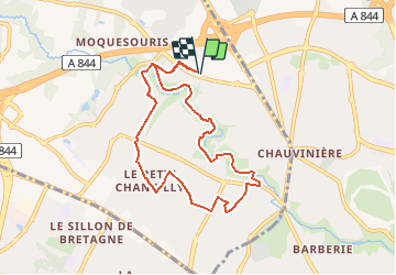
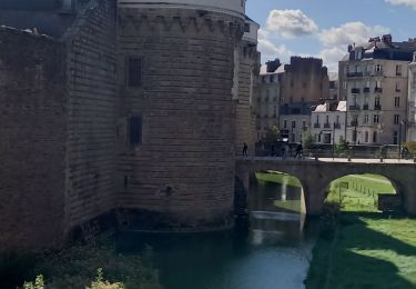
Tocht Stappen van 8,1 km beschikbaar op Pays de la Loire, Loire-Atlantique, Orvault. Deze tocht wordt voorgesteld door TEFFRA.
Beschrijving
Point de RDV parking extérieur du centre commercial Grand Val - Niveau sous-sol côté terminus tram
Plaatsbepaling
Land:
France
Regio :
Pays de la Loire
Departement/Provincie :
Loire-Atlantique
Gemeente :
Orvault
Locatie:
Unknown
Vertrek:(Dec)
Vertrek:(UTM)
606637 ; 5235188 (30T) N.
Opmerkingen
Wandeltochten in de omgeving
![Tocht Te voet La Chapelle-sur-Erdre - grand circuit Erdre/Gesvres - Photo](https://media.geolcdn.com/t/375/260/36b563d8-5e42-407f-af20-6207f8d9317f.jpeg&format=jpg&maxdim=2)
![Te voet Te voet](https://static1.geolcdn.com/sitytour/trail-icons/100.png)
grand circuit Erdre/Gesvres
Te voet
Gemakkelijk
La Chapelle-sur-Erdre,
Pays de la Loire,
Loire-Atlantique,
France
![](/images/other/stat-length.png)
4,2 km | 5,2 km-effort
1h 10min
![](https://static1.geolcdn.com/siteimages/upload/files/16400158638029165_repeat_loop_refresh_sync_direction_icon.png)
Neen
![Tocht Stappen Nantes - Nantes chezine-chantenay - Photo](https://media.geolcdn.com/t/375/260/ext.jpg?maxdim=2&url=https%3A%2F%2Fstatic1.geolcdn.com%2Fsiteimages%2Fupload%2Ffiles%2F1553511878bg_sport_marche.png)
![Stappen Stappen](https://static1.geolcdn.com/sitytour/trail-icons/101.png)
Nantes chezine-chantenay
Stappen
Heel gemakkelijk
(1)
Nantes,
Pays de la Loire,
Loire-Atlantique,
France
![](/images/other/stat-length.png)
9,5 km | 11,1 km-effort
2h 26min
![](https://static1.geolcdn.com/siteimages/upload/files/16400158638029165_repeat_loop_refresh_sync_direction_icon.png)
Ja
![Tocht Mountainbike Nantes - Nantes - Photo](https://media.geolcdn.com/t/375/260/ext.jpg?maxdim=2&url=https%3A%2F%2Fstatic1.geolcdn.com%2Fsiteimages%2Fupload%2Ffiles%2F1524743154velo.jpg)
![Mountainbike Mountainbike](https://static1.geolcdn.com/sitytour/trail-icons/202.png)
Nantes
Mountainbike
Medium
(1)
Nantes,
Pays de la Loire,
Loire-Atlantique,
France
![](/images/other/stat-length.png)
32 km | 38 km-effort
2h 6min
![](https://static1.geolcdn.com/siteimages/upload/files/16400158638029165_repeat_loop_refresh_sync_direction_icon.png)
Ja
![Tocht Te voet La Chapelle-sur-Erdre - La Source, Le Rupt, l'ancienne voie de chemin de fer - Photo](https://media.geolcdn.com/t/375/260/dd46a926-2019-47c5-9f72-3994a23fb768.jpeg&format=jpg&maxdim=2)
![Te voet Te voet](https://static1.geolcdn.com/sitytour/trail-icons/100.png)
La Source, Le Rupt, l'ancienne voie de chemin de fer
Te voet
Gemakkelijk
La Chapelle-sur-Erdre,
Pays de la Loire,
Loire-Atlantique,
France
![](/images/other/stat-length.png)
5,5 km | 6,2 km-effort
1h 25min
![](https://static1.geolcdn.com/siteimages/upload/files/16400158638029165_repeat_loop_refresh_sync_direction_icon.png)
Neen
![Tocht Te voet Carquefou - Les Bords de l'Erdre - Photo](https://media.geolcdn.com/t/375/260/c7417e76-e2f6-40cc-bd1f-087623dde044.jpeg&format=jpg&maxdim=2)
![Te voet Te voet](https://static1.geolcdn.com/sitytour/trail-icons/100.png)
Les Bords de l'Erdre
Te voet
Gemakkelijk
Carquefou,
Pays de la Loire,
Loire-Atlantique,
France
![](/images/other/stat-length.png)
4,4 km | 5 km-effort
1h 8min
![](https://static1.geolcdn.com/siteimages/upload/files/16400158638029165_repeat_loop_refresh_sync_direction_icon.png)
Neen
![Tocht Noords wandelen Saint-Herblain - Gournerie - Photo](https://media.geolcdn.com/t/375/260/ext.jpg?maxdim=2&url=https%3A%2F%2Fstatic1.geolcdn.com%2Fsiteimages%2Fupload%2Ffiles%2F1545311037marcheuse_200dpi.jpg)
![Noords wandelen Noords wandelen](https://static1.geolcdn.com/sitytour/trail-icons/102.png)
Gournerie
Noords wandelen
Gemakkelijk
(1)
Saint-Herblain,
Pays de la Loire,
Loire-Atlantique,
France
![](/images/other/stat-length.png)
6,1 km | 7,1 km-effort
1h 7min
![](https://static1.geolcdn.com/siteimages/upload/files/16400158638029165_repeat_loop_refresh_sync_direction_icon.png)
Ja
![Tocht Mountainbike La Chapelle-sur-Erdre - gr3 et vallée du cens - Photo](https://media.geolcdn.com/t/375/260/ext.jpg?maxdim=2&url=https%3A%2F%2Fstatic1.geolcdn.com%2Fsiteimages%2Fupload%2Ffiles%2F1524743154velo.jpg)
![Mountainbike Mountainbike](https://static1.geolcdn.com/sitytour/trail-icons/202.png)
gr3 et vallée du cens
Mountainbike
Gemakkelijk
(1)
La Chapelle-sur-Erdre,
Pays de la Loire,
Loire-Atlantique,
France
![](/images/other/stat-length.png)
25 km | 30 km-effort
Onbekend
![](https://static1.geolcdn.com/siteimages/upload/files/16400158638029165_repeat_loop_refresh_sync_direction_icon.png)
Ja
![Tocht Hybride fiets Nantes - etape n°1 l'hippodrome université Nantes à Plessis pas Brunet - Photo](https://media.geolcdn.com/t/375/260/f11b735e-088e-4766-b0fc-11001b7156c1.jpg&format=jpg&maxdim=2)
![Hybride fiets Hybride fiets](https://static1.geolcdn.com/sitytour/trail-icons/203.png)
etape n°1 l'hippodrome université Nantes à Plessis pas Brunet
Hybride fiets
Gemakkelijk
Nantes,
Pays de la Loire,
Loire-Atlantique,
France
![](/images/other/stat-length.png)
30 km | 33 km-effort
2h 48min
![](https://static1.geolcdn.com/siteimages/upload/files/16400158638029165_repeat_loop_refresh_sync_direction_icon.png)
Neen
![Tocht Stappen La Chapelle-sur-Erdre - Nantes - Photo](https://media.geolcdn.com/t/375/260/c71f4b0c-4767-4bda-b5dd-03deb4e6ff77.jpg&format=jpg&maxdim=2)
![Stappen Stappen](https://static1.geolcdn.com/sitytour/trail-icons/101.png)
Nantes
Stappen
Medium
La Chapelle-sur-Erdre,
Pays de la Loire,
Loire-Atlantique,
France
![](/images/other/stat-length.png)
8,3 km | 9,6 km-effort
2h 32min
![](https://static1.geolcdn.com/siteimages/upload/files/16400158638029165_repeat_loop_refresh_sync_direction_icon.png)
Neen