


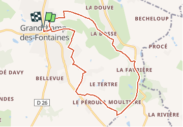

15,7 km | 17,3 km-effort


Gebruiker


Gratisgps-wandelapplicatie
 SityTrail
IGN / Geografische instituten
SityTrail World
De wereld gaat voor u open
Tocht Stappen van 9,4 km beschikbaar op Pays de la Loire, Loire-Atlantique, Grandchamp-des-Fontaines. Deze tocht wordt voorgesteld door TEFFRA.
Point de RDV parking avenue du Général De Gaulle. Venant de Nantes à gauche après l'église et la pharmacie

Stappen
Stappen
Te voet

Te voet

Wegfiets

Te voet

Paard

Mountainbike
Stappen