![](/images/other/stat-length.png)
![Tocht Stappen Ouistreham - Ouistreham à Lion-sur-Mer (Aller-retour). - Photo](https://media.geolcdn.com/t/1900/400/ext.pjpeg?maxdim=2&url=https%3A%2F%2Fstatic1.geolcdn.com%2Fsiteimages%2Fupload%2Ffiles%2F1553511878bg_sport_marche.png)
Ouistreham à Lion-sur-Mer (Aller-retour).
toporient
Gebruiker
![Lengte](/images/other/stat-length.png)
Lengte
9,5 km
![Max. hoogte](https://static1.geolcdn.com/siteimages/upload/files/1508320355ic_sort_altitude_max_24dp.png)
Max. hoogte
10 m
![Positief hoogteverschil](https://static1.geolcdn.com/siteimages/upload/files/1508320355ic_sort_den_pos_24dp.png)
Positief hoogteverschil
51 m
![Km-Effort](/images/other/stat-length.png)
Km-Effort
10,2 km
![Min. hoogte](https://static1.geolcdn.com/siteimages/upload/files/1508320355ic_sort_altitude_min_24dp.png)
Min. hoogte
0 m
![Negatief hoogteverschil](https://static1.geolcdn.com/siteimages/upload/files/1508320355ic_sort_den_neg_24dp.png)
Negatief hoogteverschil
51 m
![Boucle](https://static1.geolcdn.com/siteimages/upload/files/16400158638029165_repeat_loop_refresh_sync_direction_icon.png)
Boucle
Ja
Datum van aanmaak :
2018-04-17 14:39:28.671
Laatste wijziging :
2018-04-17 14:39:28.671
![Stappen](https://static1.geolcdn.com/sitytour/trail-icons/101.png)
2h20
Moeilijkheid : Gemakkelijk
![Scan deze QR-code om de tocht te openen in de SityTrail-applicatie](https://capi.geolives.com/qq0zvz2zws4bq2lad0pu/sitytour/trails/875929/qr.png?size=200)
Gratisgps-wandelapplicatie
Over ons
Tocht Stappen van 9,5 km beschikbaar op Normandië, Calvados, Ouistreham. Deze tocht wordt voorgesteld door toporient.
Beschrijving
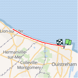
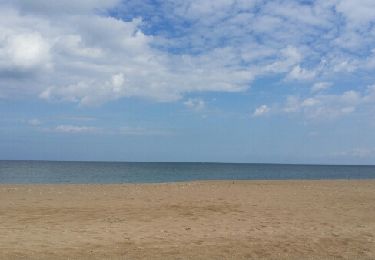
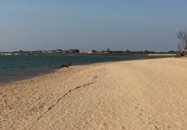
Circuit aller-retour de Ouistreham à Lion-sur-Mer par Collevile-Montgomery et Hermanville, en suivant la promenade du bord de mer.
(Distance à parcourir modulable en fonction de ses capacités; circuit idéal en famille).
Plaatsbepaling
Land:
France
Regio :
Normandië
Departement/Provincie :
Calvados
Gemeente :
Ouistreham
Locatie:
Unknown
Vertrek:(Dec)
Vertrek:(UTM)
699396 ; 5463146 (30U) N.
Opmerkingen
Wandeltochten in de omgeving
![Tocht Stappen Merville-Franceville-Plage - Balade découverte autour de Merville - Photo](https://media.geolcdn.com/t/375/260/d0b7039c-e1ac-4daf-b212-abb8614d96e7.jpg&format=jpg&maxdim=2)
![Stappen Stappen](https://static1.geolcdn.com/sitytour/trail-icons/101.png)
Balade découverte autour de Merville
Stappen
Heel gemakkelijk
Merville-Franceville-Plage,
Normandië,
Calvados,
France
![](/images/other/stat-length.png)
12,3 km | 13,2 km-effort
2h 48min
![](https://static1.geolcdn.com/siteimages/upload/files/16400158638029165_repeat_loop_refresh_sync_direction_icon.png)
Ja
![Tocht Mountainbike Colleville-Montgomery - Ouistreham - Salennelles - Photo](https://media.geolcdn.com/t/375/260/ext.jpg?maxdim=2&url=https%3A%2F%2Fstatic1.geolcdn.com%2Fsiteimages%2Fupload%2Ffiles%2F1524743154velo.jpg)
![Mountainbike Mountainbike](https://static1.geolcdn.com/sitytour/trail-icons/202.png)
Ouistreham - Salennelles
Mountainbike
Medium
(1)
Colleville-Montgomery,
Normandië,
Calvados,
France
![](/images/other/stat-length.png)
30 km | 33 km-effort
2h 0min
![](https://static1.geolcdn.com/siteimages/upload/files/16400158638029165_repeat_loop_refresh_sync_direction_icon.png)
Ja
![Tocht Stappen Merville-Franceville-Plage - HONFLEUR 06 - OUISTREHAM : Les Dunes - La Redoute (Normandie) - Photo](https://media.geolcdn.com/t/375/260/3672140d-5a9b-46d0-a351-c2d13b398b9e.jpg&format=jpg&maxdim=2)
![Stappen Stappen](https://static1.geolcdn.com/sitytour/trail-icons/101.png)
HONFLEUR 06 - OUISTREHAM : Les Dunes - La Redoute (Normandie)
Stappen
Medium
Merville-Franceville-Plage,
Normandië,
Calvados,
France
![](/images/other/stat-length.png)
6,5 km | 6,8 km-effort
1h 55min
![](https://static1.geolcdn.com/siteimages/upload/files/16400158638029165_repeat_loop_refresh_sync_direction_icon.png)
Ja
![Tocht Wegfiets Merville-Franceville-Plage - Merville Caen - Photo](https://media.geolcdn.com/t/375/260/c81a8d40-bd2c-4971-b1f0-ce64fccb30d4.jpg&format=jpg&maxdim=2)
![Wegfiets Wegfiets](https://static1.geolcdn.com/sitytour/trail-icons/201.png)
Merville Caen
Wegfiets
Merville-Franceville-Plage,
Normandië,
Calvados,
France
![](/images/other/stat-length.png)
31 km | 34 km-effort
2h 11min
![](https://static1.geolcdn.com/siteimages/upload/files/16400158638029165_repeat_loop_refresh_sync_direction_icon.png)
Ja
![Tocht Stappen Ouistreham - Oustreham - Photo](https://media.geolcdn.com/t/375/260/45ffe55d-02b7-4967-8287-a80bed6a58aa.jpg&format=jpg&maxdim=2)
![Stappen Stappen](https://static1.geolcdn.com/sitytour/trail-icons/101.png)
Boucle entre plage et marais
Stappen
Gemakkelijk
Merville-Franceville-Plage,
Normandië,
Calvados,
France
![](/images/other/stat-length.png)
8,6 km | 9,1 km-effort
2h 8min
![](https://static1.geolcdn.com/siteimages/upload/files/16400158638029165_repeat_loop_refresh_sync_direction_icon.png)
Ja
![Tocht Stappen Sallenelles - Sellenelles à Franceville Merville - Photo](https://media.geolcdn.com/t/375/260/ext.jpg?maxdim=2&url=https%3A%2F%2Fservices.sitytrail.com%2FGeolivesWS%2FDownloadMedia.ashx%3FTrailID%3D756905%26Media%3Dfix__20170513120035.jpg)
![Stappen Stappen](https://static1.geolcdn.com/sitytour/trail-icons/101.png)
Sellenelles à Franceville Merville
Stappen
Gemakkelijk
Sallenelles,
Normandië,
Calvados,
France
![](/images/other/stat-length.png)
10,7 km | 11,7 km-effort
2h 36min
![](https://static1.geolcdn.com/siteimages/upload/files/16400158638029165_repeat_loop_refresh_sync_direction_icon.png)
Neen
![Tocht Lopen Merville-Franceville-Plage - circuit autour de merville - Photo](https://media.geolcdn.com/t/375/260/ext.jpg?maxdim=2&url=https%3A%2F%2Fservices.sitytrail.com%2FGeolivesWS%2FDownloadMedia.ashx%3FTrailID%3D736587%26Media%3D20170420180024.jpg)
![Lopen Lopen](https://static1.geolcdn.com/sitytour/trail-icons/103.png)
circuit autour de merville
Lopen
Heel gemakkelijk
Merville-Franceville-Plage,
Normandië,
Calvados,
France
![](/images/other/stat-length.png)
10,1 km | 10,8 km-effort
1h 7min
![](https://static1.geolcdn.com/siteimages/upload/files/16400158638029165_repeat_loop_refresh_sync_direction_icon.png)
Ja
![Tocht Mountainbike Hermanville-sur-Mer - trace - Photo](https://media.geolcdn.com/t/375/260/ext.jpg?maxdim=2&url=https%3A%2F%2Fstatic1.geolcdn.com%2Fsiteimages%2Fupload%2Ffiles%2F1524743154velo.jpg)
![Mountainbike Mountainbike](https://static1.geolcdn.com/sitytour/trail-icons/202.png)
trace
Mountainbike
Gemakkelijk
(1)
Hermanville-sur-Mer,
Normandië,
Calvados,
France
![](/images/other/stat-length.png)
26 km | 28 km-effort
Onbekend
![](https://static1.geolcdn.com/siteimages/upload/files/16400158638029165_repeat_loop_refresh_sync_direction_icon.png)
Ja