![](/images/other/stat-length.png)
![Tocht Stappen La Crau - Hyères Le Fenouillet - Hyères au départ de la Crau - Photo](https://media.geolcdn.com/t/1900/400/ext.pjpeg?maxdim=2&url=https%3A%2F%2Fstatic1.geolcdn.com%2Fsiteimages%2Fupload%2Ffiles%2F1553511878bg_sport_marche.png)
Hyères Le Fenouillet - Hyères au départ de la Crau
E.BURCK
Gebruiker
![Lengte](/images/other/stat-length.png)
![Max. hoogte](https://static1.geolcdn.com/siteimages/upload/files/1508320355ic_sort_altitude_max_24dp.png)
![Positief hoogteverschil](https://static1.geolcdn.com/siteimages/upload/files/1508320355ic_sort_den_pos_24dp.png)
![Km-Effort](/images/other/stat-length.png)
![Min. hoogte](https://static1.geolcdn.com/siteimages/upload/files/1508320355ic_sort_altitude_min_24dp.png)
![Negatief hoogteverschil](https://static1.geolcdn.com/siteimages/upload/files/1508320355ic_sort_den_neg_24dp.png)
![Boucle](https://static1.geolcdn.com/siteimages/upload/files/16400158638029165_repeat_loop_refresh_sync_direction_icon.png)
![Stappen](https://static1.geolcdn.com/sitytour/trail-icons/101.png)
4h20
Moeilijkheid : Medium
![Scan deze QR-code om de tocht te openen in de SityTrail-applicatie](https://capi.geolives.com/qq0zvz2zws4bq2lad0pu/sitytour/trails/828461/qr.png?size=200)
Gratisgps-wandelapplicatie
Over ons
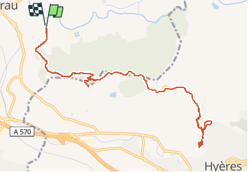
Tocht Stappen van 13,8 km beschikbaar op Provence-Alpes-Côte d'Azur, Var, La Crau. Deze tocht wordt voorgesteld door E.BURCK.
Beschrijving
Une randonnée qui associera activité sportive et culturelle. En effet, celle-ci nous entraînera dans la découverte des vestiges du Château de Hyères. La municipalité a équipé le site de panneaux explicatifs ce qui nous permet d'imaginer la vie de l'époque. Auparavant, cette belle balade nous fera connaître la Chapelle Notre-Dame du Fenouillet, récemment rénovée.
Plaatsbepaling
Opmerkingen
Wandeltochten in de omgeving
![Tocht Stappen La Crau - Le Paradis et le mont des oiseaux - Photo](https://media.geolcdn.com/t/375/260/3ea9709f-1bf2-4174-850e-73122825f7f5.jpg&format=jpg&maxdim=2)
![Stappen Stappen](https://static1.geolcdn.com/sitytour/trail-icons/101.png)
Stappen
![](/images/other/stat-length.png)
![](https://static1.geolcdn.com/siteimages/upload/files/16400158638029165_repeat_loop_refresh_sync_direction_icon.png)
![Tocht Stappen La Crau - fenouillet Daniel Louis - Photo](https://media.geolcdn.com/t/375/260/74a8e577-0c5f-4f83-9925-bb595eab64a1.jpg&format=jpg&maxdim=2)
![Stappen Stappen](https://static1.geolcdn.com/sitytour/trail-icons/101.png)
Stappen
![](/images/other/stat-length.png)
![](https://static1.geolcdn.com/siteimages/upload/files/16400158638029165_repeat_loop_refresh_sync_direction_icon.png)
![Tocht Stappen La Crau - le fenouillet un après-midi d'automne - Photo](https://media.geolcdn.com/t/375/260/ext.jpg?maxdim=2&url=https%3A%2F%2Fservices.sitytrail.com%2FGeolivesWS%2FDownloadMedia.ashx%3FTrailID%3D650501%26Media%3D20161024161101.jpg)
![Stappen Stappen](https://static1.geolcdn.com/sitytour/trail-icons/101.png)
Stappen
![](/images/other/stat-length.png)
![](https://static1.geolcdn.com/siteimages/upload/files/16400158638029165_repeat_loop_refresh_sync_direction_icon.png)
![Tocht Trail Solliès-Pont - Mont Goudon boucle - Photo](https://media.geolcdn.com/t/375/260/c2cc87c3-0b5e-469f-91a1-61249a1514ac.jpg&format=jpg&maxdim=2)
![Trail Trail](https://static1.geolcdn.com/sitytour/trail-icons/104.png)
Trail
![](/images/other/stat-length.png)
![](https://static1.geolcdn.com/siteimages/upload/files/16400158638029165_repeat_loop_refresh_sync_direction_icon.png)
![Tocht Trail Solliès-Pont - Le Coudon - Photo](https://media.geolcdn.com/t/375/260/abb8f2fd-c3f3-40be-97f6-8c7a30b446a6.jpg&format=jpg&maxdim=2)
![Trail Trail](https://static1.geolcdn.com/sitytour/trail-icons/104.png)
Trail
![](/images/other/stat-length.png)
![](https://static1.geolcdn.com/siteimages/upload/files/16400158638029165_repeat_loop_refresh_sync_direction_icon.png)
![Tocht Trail La Crau - Le Fenouillet et château d' Hyères - Photo](https://media.geolcdn.com/t/375/260/b5c97bc5-16a4-4fca-8ec6-5ff57c47ff40.jpg&format=jpg&maxdim=2)
![Trail Trail](https://static1.geolcdn.com/sitytour/trail-icons/104.png)
Trail
![](/images/other/stat-length.png)
![](https://static1.geolcdn.com/siteimages/upload/files/16400158638029165_repeat_loop_refresh_sync_direction_icon.png)
![Tocht Stappen La Crau - Fenouillet - Chateau de Hyères - retour par les vignes - Photo](https://media.geolcdn.com/t/375/260/d2132167-a625-4ff2-ae44-a142bdaeb4e4.jpg&format=jpg&maxdim=2)
![Stappen Stappen](https://static1.geolcdn.com/sitytour/trail-icons/101.png)
Stappen
![](/images/other/stat-length.png)
![](https://static1.geolcdn.com/siteimages/upload/files/16400158638029165_repeat_loop_refresh_sync_direction_icon.png)
![Tocht Stappen La Farlède - La farlède-plateau de Mourras-Sollies ville-La farlède - Photo](https://media.geolcdn.com/t/375/260/a84fbeac-69b5-4bc6-a51e-04fa1dab410e.jpg&format=jpg&maxdim=2)
![Stappen Stappen](https://static1.geolcdn.com/sitytour/trail-icons/101.png)
Stappen
![](/images/other/stat-length.png)
![](https://static1.geolcdn.com/siteimages/upload/files/16400158638029165_repeat_loop_refresh_sync_direction_icon.png)
![Tocht Stappen La Farlède - Petit Coudon en partant de La Farlède - Photo](https://media.geolcdn.com/t/375/260/3e008989-684c-402b-9f5c-2d8e6fd0c68a.jpg&format=jpg&maxdim=2)
![Stappen Stappen](https://static1.geolcdn.com/sitytour/trail-icons/101.png)
Stappen
![](/images/other/stat-length.png)
![](https://static1.geolcdn.com/siteimages/upload/files/16400158638029165_repeat_loop_refresh_sync_direction_icon.png)