![](/images/other/stat-length.png)
![Tocht Stappen Bagnères-de-Luchon - Boucle Entecade,Frèche - Photo](https://media.geolcdn.com/t/1900/400/ext.pjpeg?maxdim=2&url=https%3A%2F%2Fstatic1.geolcdn.com%2Fsiteimages%2Fupload%2Ffiles%2F1553511878bg_sport_marche.png)
Boucle Entecade,Frèche
Rouzier
Gebruiker
![Lengte](/images/other/stat-length.png)
Lengte
14,9 km
![Max. hoogte](https://static1.geolcdn.com/siteimages/upload/files/1508320355ic_sort_altitude_max_24dp.png)
Max. hoogte
2257 m
![Positief hoogteverschil](https://static1.geolcdn.com/siteimages/upload/files/1508320355ic_sort_den_pos_24dp.png)
Positief hoogteverschil
1182 m
![Km-Effort](/images/other/stat-length.png)
Km-Effort
31 km
![Min. hoogte](https://static1.geolcdn.com/siteimages/upload/files/1508320355ic_sort_altitude_min_24dp.png)
Min. hoogte
1379 m
![Negatief hoogteverschil](https://static1.geolcdn.com/siteimages/upload/files/1508320355ic_sort_den_neg_24dp.png)
Negatief hoogteverschil
1176 m
![Boucle](https://static1.geolcdn.com/siteimages/upload/files/16400158638029165_repeat_loop_refresh_sync_direction_icon.png)
Boucle
Ja
Datum van aanmaak :
2018-04-16 22:28:32.464
Laatste wijziging :
2018-04-16 22:28:32.464
![Stappen](https://static1.geolcdn.com/sitytour/trail-icons/101.png)
5h20
Moeilijkheid : Moeilijk
![Scan deze QR-code om de tocht te openen in de SityTrail-applicatie](https://capi.geolives.com/qq0zvz2zws4bq2lad0pu/sitytour/trails/825077/qr.png?size=200)
Gratisgps-wandelapplicatie
Over ons
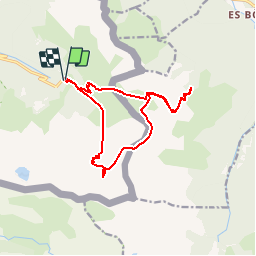
Tocht Stappen van 14,9 km beschikbaar op Occitanië, Haute-Garonne, Bagnères-de-Luchon. Deze tocht wordt voorgesteld door Rouzier.
Beschrijving
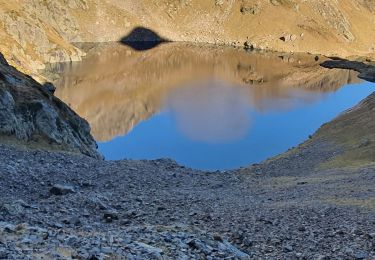
Hospice de France,Entecade,Pic de la Mounjoye,Pas de la Mounjoye,Etang de la Frèche(difficultés dans les Pales de Miche,pas de sentier),cabanes de la Frèche et du Pesson,Hospice de France.
Plaatsbepaling
Land:
France
Regio :
Occitanië
Departement/Provincie :
Haute-Garonne
Gemeente :
Bagnères-de-Luchon
Locatie:
Unknown
Vertrek:(Dec)
Vertrek:(UTM)
307914 ; 4732520 (31T) N.
Opmerkingen
Wandeltochten in de omgeving
![Tocht Stappen Bagnères-de-Luchon - 2022-06-28_22h13m18_chemin_de_l'impératrice_entre_l'hospice_de_france_ - Photo](https://media.geolcdn.com/t/375/260/ext.jpg?maxdim=2&url=https%3A%2F%2Fstatic1.geolcdn.com%2Fsiteimages%2Fupload%2Ffiles%2F1553511878bg_sport_marche.png)
![Stappen Stappen](https://static1.geolcdn.com/sitytour/trail-icons/101.png)
2022-06-28_22h13m18_chemin_de_l'impératrice_entre_l'hospice_de_france_
Stappen
Medium
(1)
Bagnères-de-Luchon,
Occitanië,
Haute-Garonne,
France
![](/images/other/stat-length.png)
5,4 km | 8,8 km-effort
2h 0min
![](https://static1.geolcdn.com/siteimages/upload/files/16400158638029165_repeat_loop_refresh_sync_direction_icon.png)
Neen
![Te voet Te voet](https://static1.geolcdn.com/sitytour/trail-icons/100.png)
SityTrail - pic de Sauvegarde
Te voet
Moeilijk
Bagnères-de-Luchon,
Occitanië,
Haute-Garonne,
France
![](/images/other/stat-length.png)
8,5 km | 22 km-effort
8h 0min
![](https://static1.geolcdn.com/siteimages/upload/files/16400158638029165_repeat_loop_refresh_sync_direction_icon.png)
Neen
![Tocht Stappen Vielha e Mijaran - Boucle du Col des Aranais par le Trou du Toro - Photo](https://media.geolcdn.com/t/375/260/ext.jpg?maxdim=2&url=https%3A%2F%2Fservices.sitytrail.com%2FGeolivesWS%2FDownloadMedia.ashx%3FTrailID%3D471659%26Media%3De674941f-343b-4414-82ec-cab02a601634.jpg)
![Stappen Stappen](https://static1.geolcdn.com/sitytour/trail-icons/101.png)
Boucle du Col des Aranais par le Trou du Toro
Stappen
Medium
(1)
Vielha e Mijaran,
Catalonië,
Lerida,
Spain
![](/images/other/stat-length.png)
14,1 km | 31 km-effort
7h 30min
![](https://static1.geolcdn.com/siteimages/upload/files/16400158638029165_repeat_loop_refresh_sync_direction_icon.png)
Ja
![Tocht Stappen Bagnères-de-Luchon - pic de Sauvegarde - Photo](https://media.geolcdn.com/t/375/260/ext.jpg?maxdim=2&url=https%3A%2F%2Fstatic1.geolcdn.com%2Fsiteimages%2Fupload%2Ffiles%2F1553511878bg_sport_marche.png)
![Stappen Stappen](https://static1.geolcdn.com/sitytour/trail-icons/101.png)
pic de Sauvegarde
Stappen
Medium
(2)
Bagnères-de-Luchon,
Occitanië,
Haute-Garonne,
France
![](/images/other/stat-length.png)
9,7 km | 25 km-effort
3h 9min
![](https://static1.geolcdn.com/siteimages/upload/files/16400158638029165_repeat_loop_refresh_sync_direction_icon.png)
Neen
![Tocht Stappen Bagnères-de-Luchon - Pic de Pouylané - Entecade - Hospice de France - Photo](https://media.geolcdn.com/t/375/260/ext.jpg?maxdim=2&url=https%3A%2F%2Fstatic1.geolcdn.com%2Fsiteimages%2Fupload%2Ffiles%2F1553511878bg_sport_marche.png)
![Stappen Stappen](https://static1.geolcdn.com/sitytour/trail-icons/101.png)
Pic de Pouylané - Entecade - Hospice de France
Stappen
Moeilijk
(1)
Bagnères-de-Luchon,
Occitanië,
Haute-Garonne,
France
![](/images/other/stat-length.png)
10,6 km | 24 km-effort
5h 39min
![](https://static1.geolcdn.com/siteimages/upload/files/16400158638029165_repeat_loop_refresh_sync_direction_icon.png)
Ja
![Tocht Stappen Bagnères-de-Luchon - retour du Port de Venasque à l'Hospice de France - Photo](https://media.geolcdn.com/t/375/260/04a57015-3c03-4c2a-8e97-13f691457724.jpg&format=jpg&maxdim=2)
![Stappen Stappen](https://static1.geolcdn.com/sitytour/trail-icons/101.png)
retour du Port de Venasque à l'Hospice de France
Stappen
Moeilijk
Bagnères-de-Luchon,
Occitanië,
Haute-Garonne,
France
![](/images/other/stat-length.png)
8,4 km | 14,3 km-effort
3h 14min
![](https://static1.geolcdn.com/siteimages/upload/files/16400158638029165_repeat_loop_refresh_sync_direction_icon.png)
Neen
![Tocht Stappen Bagnères-de-Luchon - boums du Port de Venasque - Photo](https://media.geolcdn.com/t/375/260/df9e34d2-76d3-43bd-aa0a-5a1ee9989756.jpg&format=jpg&maxdim=2)
![Stappen Stappen](https://static1.geolcdn.com/sitytour/trail-icons/101.png)
boums du Port de Venasque
Stappen
Zeer moeilijk
Bagnères-de-Luchon,
Occitanië,
Haute-Garonne,
France
![](/images/other/stat-length.png)
10,7 km | 23 km-effort
5h 6min
![](https://static1.geolcdn.com/siteimages/upload/files/16400158638029165_repeat_loop_refresh_sync_direction_icon.png)
Ja
![Tocht Stappen Bagnères-de-Luchon - l'Entecade en boucle depuis l'hospice de France - Photo](https://media.geolcdn.com/t/375/260/acefd748-9ec5-46e6-acdb-8b7ecc124aba.jpg&format=jpg&maxdim=2)
![Stappen Stappen](https://static1.geolcdn.com/sitytour/trail-icons/101.png)
l'Entecade en boucle depuis l'hospice de France
Stappen
Medium
Bagnères-de-Luchon,
Occitanië,
Haute-Garonne,
France
![](/images/other/stat-length.png)
12,2 km | 26 km-effort
6h 36min
![](https://static1.geolcdn.com/siteimages/upload/files/16400158638029165_repeat_loop_refresh_sync_direction_icon.png)
Neen
![Tocht Te voet Bagnères-de-Luchon - Refuge et Port de Vénasque - Photo](https://media.geolcdn.com/t/375/260/41d4f676-fe28-4afd-83c8-c8120d86425f.jpeg&format=jpg&maxdim=2)
![Te voet Te voet](https://static1.geolcdn.com/sitytour/trail-icons/100.png)
Refuge et Port de Vénasque
Te voet
Gemakkelijk
Bagnères-de-Luchon,
Occitanië,
Haute-Garonne,
France
![](/images/other/stat-length.png)
6,3 km | 16,9 km-effort
3h 50min
![](https://static1.geolcdn.com/siteimages/upload/files/16400158638029165_repeat_loop_refresh_sync_direction_icon.png)
Neen