![](/images/other/stat-length.png)
![Tocht Stappen Chef-Boutonne - chef_boutonne - Photo](https://media.geolcdn.com/t/1900/400/ext.pjpeg?maxdim=2&url=https%3A%2F%2Fstatic1.geolcdn.com%2Fsiteimages%2Fupload%2Ffiles%2F1553511878bg_sport_marche.png)
chef_boutonne
olaze
Gebruiker
![Lengte](/images/other/stat-length.png)
Lengte
8,1 km
![Max. hoogte](https://static1.geolcdn.com/siteimages/upload/files/1508320355ic_sort_altitude_max_24dp.png)
Max. hoogte
86 m
![Positief hoogteverschil](https://static1.geolcdn.com/siteimages/upload/files/1508320355ic_sort_den_pos_24dp.png)
Positief hoogteverschil
40 m
![Km-Effort](/images/other/stat-length.png)
Km-Effort
8,6 km
![Min. hoogte](https://static1.geolcdn.com/siteimages/upload/files/1508320355ic_sort_altitude_min_24dp.png)
Min. hoogte
71 m
![Negatief hoogteverschil](https://static1.geolcdn.com/siteimages/upload/files/1508320355ic_sort_den_neg_24dp.png)
Negatief hoogteverschil
39 m
![Boucle](https://static1.geolcdn.com/siteimages/upload/files/16400158638029165_repeat_loop_refresh_sync_direction_icon.png)
Boucle
Ja
Datum van aanmaak :
2017-09-03 00:00:00.0
Laatste wijziging :
2017-09-03 00:00:00.0
![Stappen](https://static1.geolcdn.com/sitytour/trail-icons/101.png)
1h56
Moeilijkheid : Gemakkelijk
![Scan deze QR-code om de tocht te openen in de SityTrail-applicatie](https://capi.geolives.com/qq0zvz2zws4bq2lad0pu/sitytour/trails/822173/qr.png?size=200)
Gratisgps-wandelapplicatie
Over ons
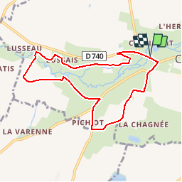
Tocht Stappen van 8,1 km beschikbaar op Nieuw-Aquitanië, Deux-Sèvres, Chef-Boutonne. Deze tocht wordt voorgesteld door olaze.
Beschrijving
Balade qui alliera découvertes patrimoniales et rencontre avec la nature. Puits, Porche, Eglise, Château de Javarzay, Arbre remarquable, Fontaine - lavoir, Bâtisse ancienne, Point de vue, Fontaine - lavoir, Logis - manoir, Logis - manoir, Pigeonnier. Départ Château de Javarzay.
Plaatsbepaling
Land:
France
Regio :
Nieuw-Aquitanië
Departement/Provincie :
Deux-Sèvres
Gemeente :
Chef-Boutonne
Locatie:
Chef-Boutonne
Vertrek:(Dec)
Vertrek:(UTM)
725386 ; 5110314 (30T) N.
Opmerkingen
Wandeltochten in de omgeving
![Tocht Stappen Chef-Boutonne - La Somptueuse - Photo](https://media.geolcdn.com/t/375/260/ext.jpg?maxdim=2&url=https%3A%2F%2Fstatic1.geolcdn.com%2Fsiteimages%2Fupload%2Ffiles%2F1553511878bg_sport_marche.png)
![Stappen Stappen](https://static1.geolcdn.com/sitytour/trail-icons/101.png)
La Somptueuse
Stappen
Gemakkelijk
Chef-Boutonne,
Nieuw-Aquitanië,
Deux-Sèvres,
France
![](/images/other/stat-length.png)
11,7 km | 13,4 km-effort
2h 30min
![](https://static1.geolcdn.com/siteimages/upload/files/16400158638029165_repeat_loop_refresh_sync_direction_icon.png)
Ja
![Tocht Stappen Chef-Boutonne - La Somptueuse 2 - Photo](https://media.geolcdn.com/t/375/260/ext.jpg?maxdim=2&url=https%3A%2F%2Fstatic1.geolcdn.com%2Fsiteimages%2Fupload%2Ffiles%2F1553511878bg_sport_marche.png)
![Stappen Stappen](https://static1.geolcdn.com/sitytour/trail-icons/101.png)
La Somptueuse 2
Stappen
Gemakkelijk
(1)
Chef-Boutonne,
Nieuw-Aquitanië,
Deux-Sèvres,
France
![](/images/other/stat-length.png)
10 km | 11,2 km-effort
2h 30min
![](https://static1.geolcdn.com/siteimages/upload/files/16400158638029165_repeat_loop_refresh_sync_direction_icon.png)
Ja