![](/images/other/stat-length.png)
![Tocht Stappen Saint-Dié-des-Vosges - Saint-Dié-des-Vosges - La Bure 24 200m +881m - Photo](https://media.geolcdn.com/t/1900/400/ext.pjpeg?maxdim=2&url=https%3A%2F%2Fstatic1.geolcdn.com%2Fsiteimages%2Fupload%2Ffiles%2F1553511878bg_sport_marche.png)
Saint-Dié-des-Vosges - La Bure 24 200m +881m
DanielROLLET
Gebruiker
![Lengte](/images/other/stat-length.png)
Lengte
24 km
![Max. hoogte](https://static1.geolcdn.com/siteimages/upload/files/1508320355ic_sort_altitude_max_24dp.png)
Max. hoogte
888 m
![Positief hoogteverschil](https://static1.geolcdn.com/siteimages/upload/files/1508320355ic_sort_den_pos_24dp.png)
Positief hoogteverschil
880 m
![Km-Effort](/images/other/stat-length.png)
Km-Effort
35 km
![Min. hoogte](https://static1.geolcdn.com/siteimages/upload/files/1508320355ic_sort_altitude_min_24dp.png)
Min. hoogte
335 m
![Negatief hoogteverschil](https://static1.geolcdn.com/siteimages/upload/files/1508320355ic_sort_den_neg_24dp.png)
Negatief hoogteverschil
880 m
![Boucle](https://static1.geolcdn.com/siteimages/upload/files/16400158638029165_repeat_loop_refresh_sync_direction_icon.png)
Boucle
Ja
Datum van aanmaak :
2018-04-16 22:10:16.656
Laatste wijziging :
2018-04-16 22:10:16.656
![Stappen](https://static1.geolcdn.com/sitytour/trail-icons/101.png)
7h30
Moeilijkheid : Moeilijk
![Scan deze QR-code om de tocht te openen in de SityTrail-applicatie](https://capi.geolives.com/qq0zvz2zws4bq2lad0pu/sitytour/trails/821879/qr.png?size=200)
Gratisgps-wandelapplicatie
Over ons
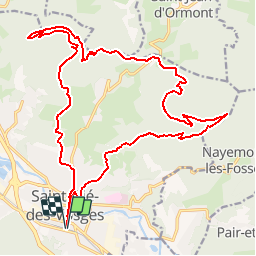
Tocht Stappen van 24 km beschikbaar op Grand Est, Vogezen, Saint-Dié-des-Vosges. Deze tocht wordt voorgesteld door DanielROLLET.
Beschrijving
2017 09 02 avec Marie
marche 9h15 à 17h05
Départ/retour gare SNCF
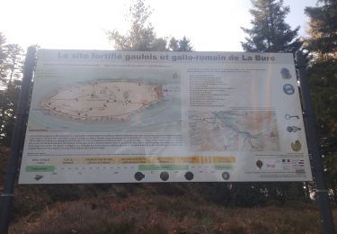
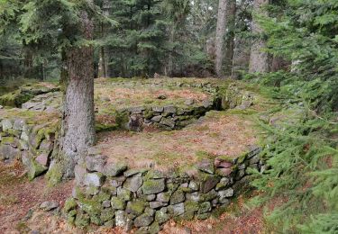
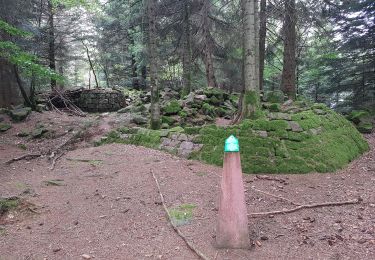
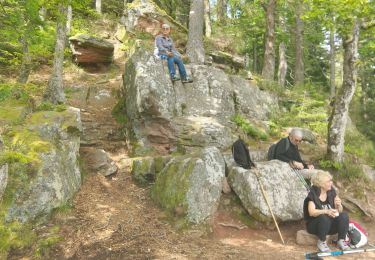
Grosse erreur à la Fontaine du Coeur en redescendant du Camp Celtique (20mn)
Plaatsbepaling
Land:
France
Regio :
Grand Est
Departement/Provincie :
Vogezen
Gemeente :
Saint-Dié-des-Vosges
Locatie:
Unknown
Vertrek:(Dec)
Vertrek:(UTM)
347812 ; 5349686 (32U) N.
Opmerkingen
Wandeltochten in de omgeving
![Tocht Mountainbike Saint-Dié-des-Vosges - vtt la voivre La Bure 29-03-19 - Photo](https://media.geolcdn.com/t/375/260/651ec868-e046-448c-a37f-e725fa61f50d.jpg&format=jpg&maxdim=2)
![Mountainbike Mountainbike](https://static1.geolcdn.com/sitytour/trail-icons/202.png)
vtt la voivre La Bure 29-03-19
Mountainbike
Moeilijk
(2)
Saint-Dié-des-Vosges,
Grand Est,
Vogezen,
France
![](/images/other/stat-length.png)
20 km | 28 km-effort
2h 48min
![](https://static1.geolcdn.com/siteimages/upload/files/16400158638029165_repeat_loop_refresh_sync_direction_icon.png)
Ja
![Tocht Stappen Saint-Michel-sur-Meurthe - massif de la madeleine - Photo](https://media.geolcdn.com/t/375/260/ext.jpg?maxdim=2&url=https%3A%2F%2Fservices.sitytrail.com%2FGeolivesWS%2FDownloadMedia.ashx%3FTrailID%3D1148232%26Media%3D20190421153638.jpg)
![Stappen Stappen](https://static1.geolcdn.com/sitytour/trail-icons/101.png)
massif de la madeleine
Stappen
Medium
(1)
Saint-Michel-sur-Meurthe,
Grand Est,
Vogezen,
France
![](/images/other/stat-length.png)
14,7 km | 22 km-effort
4h 10min
![](https://static1.geolcdn.com/siteimages/upload/files/16400158638029165_repeat_loop_refresh_sync_direction_icon.png)
Ja
![Tocht Te voet Taintrux - GR de Pays de Déodatie - Photo](https://media.geolcdn.com/t/375/260/8c9d86c2-6a8a-421f-b627-7552051e9313.jpeg&format=jpg&maxdim=2)
![Te voet Te voet](https://static1.geolcdn.com/sitytour/trail-icons/100.png)
GR de Pays de Déodatie
Te voet
Gemakkelijk
Taintrux,
Grand Est,
Vogezen,
France
![](/images/other/stat-length.png)
7,9 km | 12,5 km-effort
2h 49min
![](https://static1.geolcdn.com/siteimages/upload/files/16400158638029165_repeat_loop_refresh_sync_direction_icon.png)
Neen
![Tocht Stappen Saint-Dié-des-Vosges - 2019-03-07 Marche Montée des Schlitteurs - Photo](https://media.geolcdn.com/t/375/260/b6c7faad-e93b-4a65-8c3b-cd428aea5e79.jpg&format=jpg&maxdim=2)
![Stappen Stappen](https://static1.geolcdn.com/sitytour/trail-icons/101.png)
2019-03-07 Marche Montée des Schlitteurs
Stappen
Heel gemakkelijk
Saint-Dié-des-Vosges,
Grand Est,
Vogezen,
France
![](/images/other/stat-length.png)
11,3 km | 19,6 km-effort
4h 35min
![](https://static1.geolcdn.com/siteimages/upload/files/16400158638029165_repeat_loop_refresh_sync_direction_icon.png)
Ja
![Tocht Stappen Taintrux - suuntoapp-Hiking-2024-05-10T08-54-36Z - Photo](https://media.geolcdn.com/t/375/260/9fe93acc-f8ea-40c3-b435-6f108f3a2d6d.jpg&format=jpg&maxdim=2)
![Stappen Stappen](https://static1.geolcdn.com/sitytour/trail-icons/101.png)
suuntoapp-Hiking-2024-05-10T08-54-36Z
Stappen
Medium
Taintrux,
Grand Est,
Vogezen,
France
![](/images/other/stat-length.png)
18,8 km | 32 km-effort
7h 14min
![](https://static1.geolcdn.com/siteimages/upload/files/16400158638029165_repeat_loop_refresh_sync_direction_icon.png)
Neen
![Tocht Stappen Saint-Dié-des-Vosges - Massif de l'Ormont et ses rochers remarquables - Photo](https://media.geolcdn.com/t/375/260/5bfc527b-060c-4d01-aae8-b360a5c8e4f1.jpg&format=jpg&maxdim=2)
![Stappen Stappen](https://static1.geolcdn.com/sitytour/trail-icons/101.png)
Massif de l'Ormont et ses rochers remarquables
Stappen
Zeer moeilijk
Saint-Dié-des-Vosges,
Grand Est,
Vogezen,
France
![](/images/other/stat-length.png)
15,9 km | 25 km-effort
5h 38min
![](https://static1.geolcdn.com/siteimages/upload/files/16400158638029165_repeat_loop_refresh_sync_direction_icon.png)
Ja
![Tocht Stappen Saulcy-sur-Meurthe - Massif du KEMBERG - Photo](https://media.geolcdn.com/t/375/260/a0e83b61-8364-418a-96af-6be211e18cd3.jpg&format=jpg&maxdim=2)
![Stappen Stappen](https://static1.geolcdn.com/sitytour/trail-icons/101.png)
Massif du KEMBERG
Stappen
Zeer moeilijk
Saulcy-sur-Meurthe,
Grand Est,
Vogezen,
France
![](/images/other/stat-length.png)
12,6 km | 20 km-effort
4h 45min
![](https://static1.geolcdn.com/siteimages/upload/files/16400158638029165_repeat_loop_refresh_sync_direction_icon.png)
Ja
![Tocht Stappen Taintrux - Marche 09-07-22 18Km - Photo](https://media.geolcdn.com/t/375/260/dffd94f9-cf6a-45ad-8857-0cc31d7aeb13.jpg&format=jpg&maxdim=2)
![Stappen Stappen](https://static1.geolcdn.com/sitytour/trail-icons/101.png)
Marche 09-07-22 18Km
Stappen
Moeilijk
Taintrux,
Grand Est,
Vogezen,
France
![](/images/other/stat-length.png)
15,4 km | 24 km-effort
4h 13min
![](https://static1.geolcdn.com/siteimages/upload/files/16400158638029165_repeat_loop_refresh_sync_direction_icon.png)
Ja
![Tocht Stappen Taintrux - Marche 06-06-22 24km - Photo](https://media.geolcdn.com/t/375/260/0cc2cfac-96ee-423b-8767-12701e4ef6de.jpg&format=jpg&maxdim=2)
![Stappen Stappen](https://static1.geolcdn.com/sitytour/trail-icons/101.png)
Marche 06-06-22 24km
Stappen
Moeilijk
Taintrux,
Grand Est,
Vogezen,
France
![](/images/other/stat-length.png)
23 km | 32 km-effort
5h 48min
![](https://static1.geolcdn.com/siteimages/upload/files/16400158638029165_repeat_loop_refresh_sync_direction_icon.png)
Ja