![](/images/other/stat-length.png)
![Tocht Stappen Aarburg - Aarburg - Olten circuit 20.08.17 - Photo](https://media.geolcdn.com/t/1900/400/ext.pjpeg?maxdim=2&url=https%3A%2F%2Fservices.sitytrail.com%2FGeolivesWS%2FDownloadMedia.ashx%3FTrailID%3D813886%26Media%3D9e1f20da-adb4-494a-91d1-688e908742fc.jpg)
Aarburg - Olten circuit 20.08.17
duamerg
Gebruiker
![Lengte](/images/other/stat-length.png)
![Max. hoogte](https://static1.geolcdn.com/siteimages/upload/files/1508320355ic_sort_altitude_max_24dp.png)
![Positief hoogteverschil](https://static1.geolcdn.com/siteimages/upload/files/1508320355ic_sort_den_pos_24dp.png)
![Km-Effort](/images/other/stat-length.png)
![Min. hoogte](https://static1.geolcdn.com/siteimages/upload/files/1508320355ic_sort_altitude_min_24dp.png)
![Negatief hoogteverschil](https://static1.geolcdn.com/siteimages/upload/files/1508320355ic_sort_den_neg_24dp.png)
![Boucle](https://static1.geolcdn.com/siteimages/upload/files/16400158638029165_repeat_loop_refresh_sync_direction_icon.png)
![Stappen](https://static1.geolcdn.com/sitytour/trail-icons/101.png)
4h09
Moeilijkheid : Medium
![Scan deze QR-code om de tocht te openen in de SityTrail-applicatie](https://capi.geolives.com/qq0zvz2zws4bq2lad0pu/sitytour/trails/813886/qr.png?size=200)
Gratisgps-wandelapplicatie
Over ons
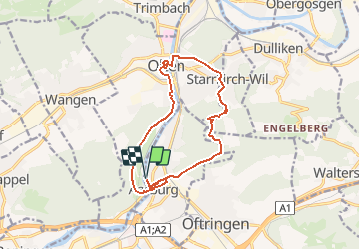
Tocht Stappen van 13,8 km beschikbaar op Aargau, Bezirk Zofingen, Aarburg. Deze tocht wordt voorgesteld door duamerg.
Beschrijving
Le train est un bon moyen de venir à Aarburg. le circuit peut aussi se faire depuis Olten.
En voiture circuit à faire un dimanche car l'on peut parquer sans limites.
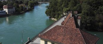
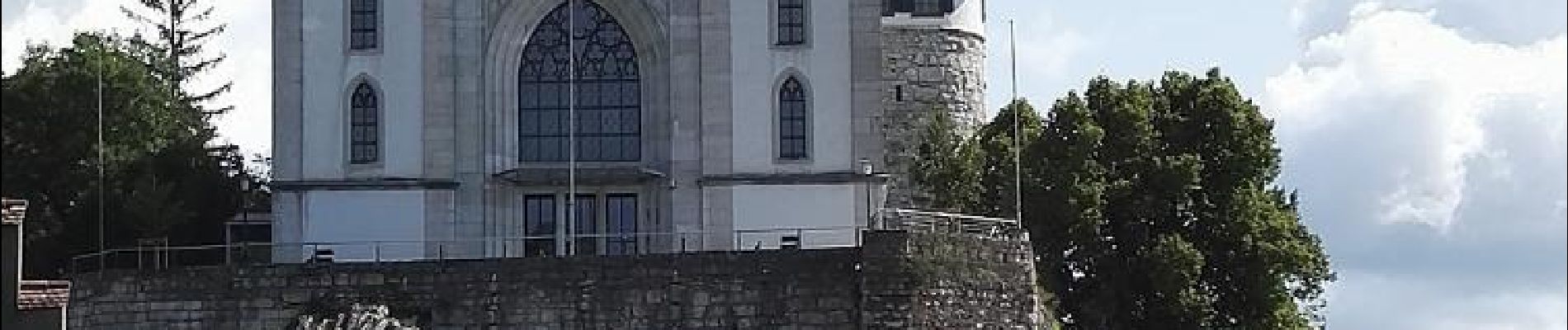
Un gros château /forteresse et une église dominent Aarburg. En faire le tour. Une toute petite partie est ouverte durant le week-end, la visite se fait uniquement le samedi à 14h. Belle vue sur l'Aar. Revenir près du pont.
Suivre les indicateurs pour aller à Olten en traversant l'Aar. Joli chemin sur les hauteurs, la fin du parcours se fait au bord de la rivière.
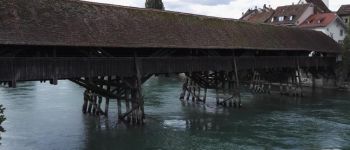
Visitez Olten, la partie historique n'est pas bien grande mais sans voitures et traversez ensuite le beau pont en bois.
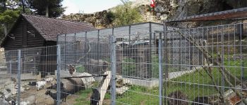
Rejoindre la gare, la traverser pour rejoindre des panneaux vous indiquant Aarburg 2h10. Il faut tout d'abord sortir de ville avant de rejoindre la campagne et un petit parc animalier qui amusera les enfants. Tout est super indiqué, on ne se perd pas.
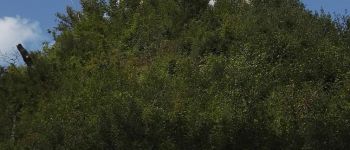
Suivre le petit ruisseau en montée avant de partir à droite en continuant à grimper jusqu'au point de vue à 664m.
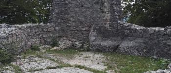
La descente commence mais faites un petit détour pour voir les ruines de Wartburg d'où l'on rejoint le chemin pédestre qui vous ramène au lieu de départ en passant à nouveau par la forteresse.
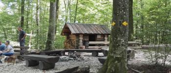
Joli course avec de nombreux points à voir. Régulièrement vous trouverez des places pour se reposer ou faire un feu.
Pas de difficultés sur le parcours.
Plaatsbepaling
Opmerkingen
Wandeltochten in de omgeving
![Tocht Te voet Olten - Walderlebnispfad Bannwald - Photo](https://media.geolcdn.com/t/375/260/ext.jpg?maxdim=2&url=https%3A%2F%2Fmedia.geolcdn.com%2Ff%2Feaa0fd53-5aa2-4561-9b7d-7487d7ce989f.jpeg)
![Te voet Te voet](https://static1.geolcdn.com/sitytour/trail-icons/100.png)
Te voet
![](/images/other/stat-length.png)
![](https://static1.geolcdn.com/siteimages/upload/files/16400158638029165_repeat_loop_refresh_sync_direction_icon.png)
![Tocht Te voet Obergösgen - Ob. Gösgen Schachen - Niedergösgen - Photo](https://media.geolcdn.com/t/375/260/ext.jpg?maxdim=2&url=https%3A%2F%2Fmedia.geolcdn.com%2Ff%2F9fee5289-ebfc-4d99-96ac-1caeecc4396d.jpeg)
![Te voet Te voet](https://static1.geolcdn.com/sitytour/trail-icons/100.png)
Te voet
![](/images/other/stat-length.png)
![](https://static1.geolcdn.com/siteimages/upload/files/16400158638029165_repeat_loop_refresh_sync_direction_icon.png)
![Tocht Te voet Murgenthal - Langholz - Ob. Sennhof - Photo](https://media.geolcdn.com/t/375/260/ext.jpg?maxdim=2&url=https%3A%2F%2Fmedia.geolcdn.com%2Ff%2Feb1453c2-05db-4c62-9179-7901e75868e3.jpeg)
![Te voet Te voet](https://static1.geolcdn.com/sitytour/trail-icons/100.png)
Te voet
![](/images/other/stat-length.png)
![](https://static1.geolcdn.com/siteimages/upload/files/16400158638029165_repeat_loop_refresh_sync_direction_icon.png)
![Tocht Te voet Wangen bei Olten - Olten - Rumpelweid - Photo](https://media.geolcdn.com/t/375/260/ext.jpg?maxdim=2&url=https%3A%2F%2Fmedia.geolcdn.com%2Ff%2F98963f72-52e0-447b-8a0f-92ec0c3f2205.jpeg)
![Te voet Te voet](https://static1.geolcdn.com/sitytour/trail-icons/100.png)
Te voet
![](/images/other/stat-length.png)
![](https://static1.geolcdn.com/siteimages/upload/files/16400158638029165_repeat_loop_refresh_sync_direction_icon.png)
![Tocht Te voet Wangen bei Olten - Wangen bei Olten - Rumpelhöchi - Photo](https://media.geolcdn.com/t/375/260/ext.jpg?maxdim=2&url=https%3A%2F%2Fmedia.geolcdn.com%2Ff%2F8265eeda-c765-48ef-990d-14843f617b15.jpeg)
![Te voet Te voet](https://static1.geolcdn.com/sitytour/trail-icons/100.png)
Te voet
![](/images/other/stat-length.png)
![](https://static1.geolcdn.com/siteimages/upload/files/16400158638029165_repeat_loop_refresh_sync_direction_icon.png)
![Tocht Te voet Olten - Wangen bei Olten - Olten - Photo](https://media.geolcdn.com/t/375/260/ext.jpg?maxdim=2&url=https%3A%2F%2Fmedia.geolcdn.com%2Ff%2F2556dfb5-5453-4583-b79f-ee99f57e7ee8.jpeg)
![Te voet Te voet](https://static1.geolcdn.com/sitytour/trail-icons/100.png)
Te voet
![](/images/other/stat-length.png)
![](https://static1.geolcdn.com/siteimages/upload/files/16400158638029165_repeat_loop_refresh_sync_direction_icon.png)
![Tocht Te voet Wangen bei Olten - Wangen bei Olten - Born - Photo](https://media.geolcdn.com/t/375/260/ext.jpg?maxdim=2&url=https%3A%2F%2Fmedia.geolcdn.com%2Ff%2F194baf9b-161b-4f48-9420-f5c23f1b3bd1.jpeg)
![Te voet Te voet](https://static1.geolcdn.com/sitytour/trail-icons/100.png)
Te voet
![](/images/other/stat-length.png)
![](https://static1.geolcdn.com/siteimages/upload/files/16400158638029165_repeat_loop_refresh_sync_direction_icon.png)
![Tocht Te voet Rickenbach (SO) - Rickenbach - Allerheiligenberg - Photo](https://media.geolcdn.com/t/375/260/ext.jpg?maxdim=2&url=https%3A%2F%2Fmedia.geolcdn.com%2Ff%2F2d74a464-e368-4642-bc65-c753a0c8a6a1.jpeg)
![Te voet Te voet](https://static1.geolcdn.com/sitytour/trail-icons/100.png)
Te voet
![](/images/other/stat-length.png)
![](https://static1.geolcdn.com/siteimages/upload/files/16400158638029165_repeat_loop_refresh_sync_direction_icon.png)
![Tocht Te voet Hägendorf - Hägendorf - Born - Photo](https://media.geolcdn.com/t/375/260/ext.jpg?maxdim=2&url=https%3A%2F%2Fmedia.geolcdn.com%2Ff%2F2f646f3a-f3b9-4dfb-bd44-9885ccdf8916.jpeg)
![Te voet Te voet](https://static1.geolcdn.com/sitytour/trail-icons/100.png)
Te voet
![](/images/other/stat-length.png)
![](https://static1.geolcdn.com/siteimages/upload/files/16400158638029165_repeat_loop_refresh_sync_direction_icon.png)