Tocht Stappen Moissac-Vallée-Française - Découverte Moissac  - Photo
 fjorez
fjorez

Gebruiker

© OpenStreetMap contributors
Lengte
Lengte
6,9 km
Max. hoogte
Max. hoogte
709 m
Positief hoogteverschil
375 m
Km-Effort
Km-Effort  
11,8 km
Min. hoogte
Min. hoogte
347 m
Negatief hoogteverschil
341 m
Boucle
Boucle
Ja
Datum van aanmaak :
2017-08-09 00:00:00.0
Laatste wijziging :
2017-08-09 00:00:00.0

(0 Bericht)

Stappen
Stappen
3h39
Moeilijkheid : Medium

Scan deze QR-code om de tocht te openen in de SityTrail-applicatie

Gratisgps-wandelapplicatie

Logo SityTrail SityTrail

IGN / Geografische instituten

SityTrail uit de App Store downloaden SityTrail uit Google Play downloaden

Logo SityTrail SityTrail World

De wereld gaat voor u open

SityTrail uit de App Store downloaden SityTrail uit Google Play downloaden SityTrail op Huawei AppGallery downloaden

Over ons

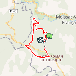
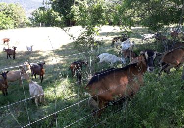
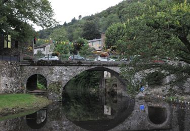
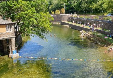
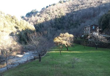
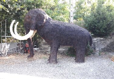
Tocht Stappen van 6,9 km beschikbaar op Occitanië, Lozère, Moissac-Vallée-Française. Deze tocht wordt voorgesteld door fjorez.

Beschrijving

7 km

Hoogteprofiel

Foto's

POI's

POI Moissac-Vallée-Française - Point 1 - Photo
fjorez
MOISSAC-VALLÉE-FRANÇAISE 
POI Moissac-Vallée-Française - panorama - Photo
fjorez
MOISSAC-VALLÉE-FRANÇAISE 
POI Saint-André-de-Valborgne - Picnic panoramique  - Photo
fjorez
SAINT-ANDRÉ-DE-VALBORGNE 
POI Moissac-Vallée-Française - Arrivé point - Photo
fjorez
MOISSAC-VALLÉE-FRANÇAISE 

Plaatsbepaling

Land:
France
Regio :
Occitanië
Departement/Provincie :
Lozère
Gemeente :
Moissac-Vallée-Française
Locatie:
Unknown
Vertrek:(Dec)
Vertrek:(UTM)
561540 ; 4889219 (31T) N.

Wandeltochten in de omgeving

Tocht Stappen Les Plantiers - Sentier de Saint Marcel de Fontfouillouse -  Les Plantiers - Photo
Stappen
tracegps

Stappen

Zeer moeilijk
(1)
Les Plantiers, Occitanië, Gard, France
13,6 km | 21 km-effort
4h 0min
Ja
Tocht Te voet Gabriac - Sentier de Gabriac - Photo
Te voet
PRO

Te voet

Gemakkelijk
Gabriac, Occitanië, Lozère, France
9,3 km | 15,5 km-effort
3h 31min
Ja
Tocht Stappen Saumane - Exil / pont des chèvres  - Photo
Stappen
GUIDE
nadinebondoux

Stappen

Moeilijk
Saumane, Occitanië, Gard, France
17,3 km | 27 km-effort
5h 53min
Ja
Tocht Stappen Les Plantiers - vallée Borgne - Photo
Stappen
GUIDE
nadinebondoux

Stappen

Moeilijk
Les Plantiers, Occitanië, Gard, France
25 km | 36 km-effort
6h 15min
Ja
Tocht Stappen Les Plantiers - Les Plantiers et st Marcel de Fontfouillouse - Photo
Stappen
GUIDE
randotines

Stappen

Moeilijk
(1)
Les Plantiers, Occitanië, Gard, France
13,6 km | 21 km-effort
4h 33min
Ja
Tocht Te voet Les Plantiers - Sentier de Fontfouillouse - Photo
Te voet
PRO

Te voet

Gemakkelijk
Les Plantiers, Occitanië, Gard, France
9,2 km | 15,2 km-effort
3h 27min
Neen
Tocht Stappen Les Plantiers - les plantiers, abbaye de Fontfouillouse  - Photo
Stappen
francislassauce

Stappen

Medium
Les Plantiers, Occitanië, Gard, France
7,4 km | 11,8 km-effort
3h 16min
Ja
Tocht Stappen Les Plantiers - St Marcel de Fontfouillousse  - Photo
Stappen
GUIDE
nadinebondoux

Stappen

Medium
Les Plantiers, Occitanië, Gard, France
14,4 km | 22 km-effort
5h 46min
Ja
Tocht Andere activiteiten Saumane - corniche cevennes  - Photo
Andere activiteiten
scombe

Andere activiteiten

Heel gemakkelijk
Saumane, Occitanië, Gard, France
31 km | 43 km-effort
2h 15min
Ja


Sluiten
Mijn abonnementen