![](/images/other/stat-length.png)
Tancarville: Les cigognes, les cygnes et la vie sauvage du marais
MarcherEnsemble
Gebruiker
![Lengte](/images/other/stat-length.png)
Lengte
8,1 km
![Max. hoogte](https://static1.geolcdn.com/siteimages/upload/files/1508320355ic_sort_altitude_max_24dp.png)
Max. hoogte
8 m
![Positief hoogteverschil](https://static1.geolcdn.com/siteimages/upload/files/1508320355ic_sort_den_pos_24dp.png)
Positief hoogteverschil
26 m
![Km-Effort](/images/other/stat-length.png)
Km-Effort
8,5 km
![Min. hoogte](https://static1.geolcdn.com/siteimages/upload/files/1508320355ic_sort_altitude_min_24dp.png)
Min. hoogte
0 m
![Negatief hoogteverschil](https://static1.geolcdn.com/siteimages/upload/files/1508320355ic_sort_den_neg_24dp.png)
Negatief hoogteverschil
28 m
![Boucle](https://static1.geolcdn.com/siteimages/upload/files/16400158638029165_repeat_loop_refresh_sync_direction_icon.png)
Boucle
Neen
Datum van aanmaak :
2017-12-26 00:00:00.0
Laatste wijziging :
2020-08-25 14:23:25.072
![Stappen](https://static1.geolcdn.com/sitytour/trail-icons/101.png)
3h00
Moeilijkheid : Heel gemakkelijk
![Scan deze QR-code om de tocht te openen in de SityTrail-applicatie](https://capi.geolives.com/qq0zvz2zws4bq2lad0pu/sitytour/trails/791460/qr.png?size=200)
Gratisgps-wandelapplicatie
Over ons
Tocht Stappen van 8,1 km beschikbaar op Normandië, Seine-Maritime, Saint-Vigor-d'Ymonville. Deze tocht wordt voorgesteld door MarcherEnsemble.
Beschrijving
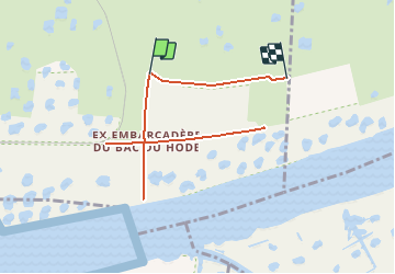
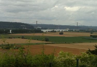
Passer rive gauche par le pont du Hode.
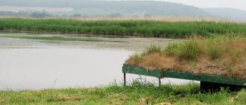
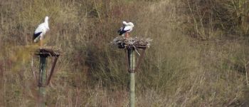
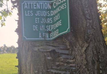
Les cigognes sont dans un espace protégé clos.
Prévoir des jumelles et un téléobjectif, il n'est pas possible de s'approcher très près.
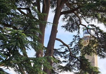
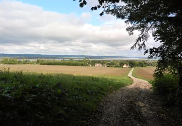
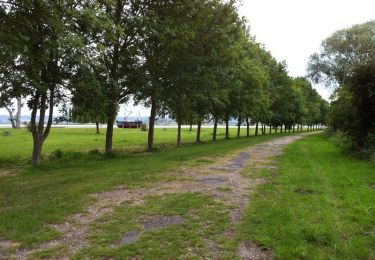
Plaatsbepaling
Land:
France
Regio :
Normandië
Departement/Provincie :
Seine-Maritime
Gemeente :
Saint-Vigor-d'Ymonville
Locatie:
Unknown
Vertrek:(Dec)
Vertrek:(UTM)
309066 ; 5481627 (31U) N.
Opmerkingen
Wandeltochten in de omgeving
![Tocht Stappen Saint-Vigor-d'Ymonville - Saint Vigor d'Ymonville - Photo](https://media.geolcdn.com/t/375/260/021f3857-a5d5-44c4-8b19-1adf31301359.jpg&format=jpg&maxdim=2)
![Stappen Stappen](https://static1.geolcdn.com/sitytour/trail-icons/101.png)
Saint Vigor d'Ymonville
Stappen
Medium
(2)
Saint-Vigor-d'Ymonville,
Normandië,
Seine-Maritime,
France
![](/images/other/stat-length.png)
9,6 km | 10,4 km-effort
2h 34min
![](https://static1.geolcdn.com/siteimages/upload/files/16400158638029165_repeat_loop_refresh_sync_direction_icon.png)
Ja
![Tocht Stappen Fatouville-Grestain - HONFLEUR 07 - Phare de Fatouville (Normandie) - Photo](https://media.geolcdn.com/t/375/260/a9f06c6b-2f5e-41a0-a622-52214993db1a.jpg&format=jpg&maxdim=2)
![Stappen Stappen](https://static1.geolcdn.com/sitytour/trail-icons/101.png)
HONFLEUR 07 - Phare de Fatouville (Normandie)
Stappen
Medium
Fatouville-Grestain,
Normandië,
Eure,
France
![](/images/other/stat-length.png)
14,7 km | 18,3 km-effort
3h 39min
![](https://static1.geolcdn.com/siteimages/upload/files/16400158638029165_repeat_loop_refresh_sync_direction_icon.png)
Ja
![Tocht Stappen Saint-Samson-de-la-Roque - La Roque - Photo](https://media.geolcdn.com/t/375/260/ext.jpg?maxdim=2&url=https%3A%2F%2Fservices.sitytrail.com%2FGeolivesWS%2FDownloadMedia.ashx%3FTrailID%3D143552%26Media%3D20120804143937.jpg)
![Stappen Stappen](https://static1.geolcdn.com/sitytour/trail-icons/101.png)
La Roque
Stappen
Heel gemakkelijk
Saint-Samson-de-la-Roque,
Normandië,
Eure,
France
![](/images/other/stat-length.png)
14,9 km | 17,7 km-effort
3h 25min
![](https://static1.geolcdn.com/siteimages/upload/files/16400158638029165_repeat_loop_refresh_sync_direction_icon.png)
Neen
![Tocht Stappen Sandouville - Sandouville 2023 10 07 - Photo](https://media.geolcdn.com/t/375/260/6695dad7-11b3-4c12-ae95-f4b2d03addac.jpg&format=jpg&maxdim=2)
![Stappen Stappen](https://static1.geolcdn.com/sitytour/trail-icons/101.png)
Sandouville 2023 10 07
Stappen
Zeer moeilijk
Sandouville,
Normandië,
Seine-Maritime,
France
![](/images/other/stat-length.png)
21 km | 26 km-effort
5h 49min
![](https://static1.geolcdn.com/siteimages/upload/files/16400158638029165_repeat_loop_refresh_sync_direction_icon.png)
Ja
![Tocht Stappen La Cerlangue - St Jean d'Abbetot - Photo](https://media.geolcdn.com/t/375/260/31650e47-20be-49a3-ad90-2dea24357470.jpg&format=jpg&maxdim=2)
![Stappen Stappen](https://static1.geolcdn.com/sitytour/trail-icons/101.png)
St Jean d'Abbetot
Stappen
Gemakkelijk
La Cerlangue,
Normandië,
Seine-Maritime,
France
![](/images/other/stat-length.png)
6,4 km | 6,8 km-effort
1h 46min
![](https://static1.geolcdn.com/siteimages/upload/files/16400158638029165_repeat_loop_refresh_sync_direction_icon.png)
Ja
![Te voet Te voet](https://static1.geolcdn.com/sitytour/trail-icons/100.png)
berville sur mer
Te voet
Heel gemakkelijk
Berville-sur-Mer,
Normandië,
Eure,
France
![](/images/other/stat-length.png)
5,5 km | 6,7 km-effort
Onbekend
![](https://static1.geolcdn.com/siteimages/upload/files/16400158638029165_repeat_loop_refresh_sync_direction_icon.png)
Ja
![Tocht Stappen Conteville - De Conteville aux bords de Seine - Photo](https://media.geolcdn.com/t/375/260/ext.jpg?maxdim=2&url=https%3A%2F%2Fservices.sitytrail.com%2FGeolivesWS%2FDownloadMedia.ashx%3FTrailID%3D129781%26Media%3D13325_1.jpg)
![Stappen Stappen](https://static1.geolcdn.com/sitytour/trail-icons/101.png)
De Conteville aux bords de Seine
Stappen
Medium
Conteville,
Normandië,
Eure,
France
![](/images/other/stat-length.png)
20 km | 24 km-effort
3h 54min
![](https://static1.geolcdn.com/siteimages/upload/files/16400158638029165_repeat_loop_refresh_sync_direction_icon.png)
Ja
![Tocht Stappen Berville-sur-Mer - Wikiloc - GR®223 Tour du Cotentin (2021) - Photo](https://media.geolcdn.com/t/375/260/ext.jpg?maxdim=2&url=https%3A%2F%2Fstatic1.geolcdn.com%2Fsiteimages%2Fupload%2Ffiles%2F1553511878bg_sport_marche.png)
![Stappen Stappen](https://static1.geolcdn.com/sitytour/trail-icons/101.png)
Wikiloc - GR®223 Tour du Cotentin (2021)
Stappen
Zeer moeilijk
Berville-sur-Mer,
Normandië,
Eure,
France
![](/images/other/stat-length.png)
650 km | 737 km-effort
167h 26min
![](https://static1.geolcdn.com/siteimages/upload/files/16400158638029165_repeat_loop_refresh_sync_direction_icon.png)
Neen
![Tocht Stappen Berville-sur-Mer - BERVILLE SUR MER - Photo](https://media.geolcdn.com/t/375/260/ext.jpg?maxdim=2&url=https%3A%2F%2Fstatic1.geolcdn.com%2Fsiteimages%2Fupload%2Ffiles%2F1553511878bg_sport_marche.png)
![Stappen Stappen](https://static1.geolcdn.com/sitytour/trail-icons/101.png)
BERVILLE SUR MER
Stappen
Moeilijk
Berville-sur-Mer,
Normandië,
Eure,
France
![](/images/other/stat-length.png)
11,1 km | 12,9 km-effort
2h 55min
![](https://static1.geolcdn.com/siteimages/upload/files/16400158638029165_repeat_loop_refresh_sync_direction_icon.png)
Ja