![](/images/other/stat-length.png)
![Tocht Stappen Passy - CHAMONIX (Les Ayères) - Photo](https://media.geolcdn.com/t/1900/400/ext.pjpeg?maxdim=2&url=https%3A%2F%2Fservices.sitytrail.com%2FGeolivesWS%2FDownloadMedia.ashx%3FTrailID%3D785049%26Media%3Dfix__20170706133737.jpg)
CHAMONIX (Les Ayères)
GerardBouche
Gebruiker
![Lengte](/images/other/stat-length.png)
![Max. hoogte](https://static1.geolcdn.com/siteimages/upload/files/1508320355ic_sort_altitude_max_24dp.png)
![Positief hoogteverschil](https://static1.geolcdn.com/siteimages/upload/files/1508320355ic_sort_den_pos_24dp.png)
![Km-Effort](/images/other/stat-length.png)
![Min. hoogte](https://static1.geolcdn.com/siteimages/upload/files/1508320355ic_sort_altitude_min_24dp.png)
![Negatief hoogteverschil](https://static1.geolcdn.com/siteimages/upload/files/1508320355ic_sort_den_neg_24dp.png)
![Boucle](https://static1.geolcdn.com/siteimages/upload/files/16400158638029165_repeat_loop_refresh_sync_direction_icon.png)
![Stappen](https://static1.geolcdn.com/sitytour/trail-icons/101.png)
3h19
Moeilijkheid : Medium
![Scan deze QR-code om de tocht te openen in de SityTrail-applicatie](https://capi.geolives.com/qq0zvz2zws4bq2lad0pu/sitytour/trails/785049/qr.png?size=200)
Gratisgps-wandelapplicatie
Over ons
Tocht Stappen van 9,5 km beschikbaar op Auvergne-Rhône-Alpes, Haute-Savoie, Passy. Deze tocht wordt voorgesteld door GerardBouche.
Beschrijving
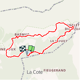
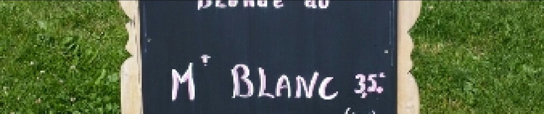
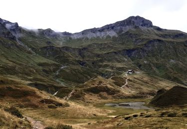
Depuis le "Lac VERT" (commune de Passy), une magnifique randonnée sous les contreforts de la chaîne des "FIZ". Quitter le parking vers la droite afin de contourner le lac Vert et le découvrir en contre-bas. Continuer vers Plaine-Joux et suivre la piste qui longe le téléski du Tour vers les "Mollays" avant d'atteindre les chalets d'alpage des Ayères (des Rocs-des Pierrières-du Souay et du Milieu). Passage à proximité du petit lac du "Gouet" avant de rejoindre le "Châtelet" où une pause s'impose pour un excellent "sorbet génépi ". En fin de parcours, ne pas manquer de faire le tour du lac.
Plaatsbepaling
Opmerkingen
Wandeltochten in de omgeving
![Tocht Stappen Passy - Tour des Ayères - Passy Plaine-Joux - Photo](https://media.geolcdn.com/t/375/260/ext.jpg?maxdim=2&url=https%3A%2F%2Fservices.sitytrail.com%2FGeolivesWS%2FDownloadMedia.ashx%3FTrailID%3D172972%26Media%3D14459_6.jpg)
![Stappen Stappen](https://static1.geolcdn.com/sitytour/trail-icons/101.png)
Stappen
![](/images/other/stat-length.png)
![](https://static1.geolcdn.com/siteimages/upload/files/16400158638029165_repeat_loop_refresh_sync_direction_icon.png)
![Tocht Stappen Passy - J10 - R8 - Plaine Joux - Les Ayères - Lac Vert - Photo](https://media.geolcdn.com/t/375/260/9c4651a9-0301-4065-a6bf-57814595ef3e.jpg&format=jpg&maxdim=2)
![Stappen Stappen](https://static1.geolcdn.com/sitytour/trail-icons/101.png)
Stappen
![](/images/other/stat-length.png)
![](https://static1.geolcdn.com/siteimages/upload/files/16400158638029165_repeat_loop_refresh_sync_direction_icon.png)
![Tocht Stappen Passy - Plaine Joux Barmus Ayères Lac Vert - Photo](https://media.geolcdn.com/t/375/260/231e6d97-0ab1-4400-9dc1-f2b1dbc1d2c1.jpg&format=jpg&maxdim=2)
![Stappen Stappen](https://static1.geolcdn.com/sitytour/trail-icons/101.png)
Stappen
![](/images/other/stat-length.png)
![](https://static1.geolcdn.com/siteimages/upload/files/16400158638029165_repeat_loop_refresh_sync_direction_icon.png)
![Tocht Stappen Passy - Plaine Joux-Passage du derochoir-Col de Portette-Platé - Photo](https://media.geolcdn.com/t/375/260/a1a5c98a-bca0-41f5-b9f9-06d73967e2da.jpg&format=jpg&maxdim=2)
![Stappen Stappen](https://static1.geolcdn.com/sitytour/trail-icons/101.png)
Stappen
![](/images/other/stat-length.png)
![](https://static1.geolcdn.com/siteimages/upload/files/16400158638029165_repeat_loop_refresh_sync_direction_icon.png)
![Tocht Lopen Passy - grimpe de chedde ayeres - Photo](https://media.geolcdn.com/t/375/260/ext.jpg?maxdim=2&url=https%3A%2F%2Fstatic1.geolcdn.com%2Fsiteimages%2Fupload%2Ffiles%2F1524743154running.jpg)
![Lopen Lopen](https://static1.geolcdn.com/sitytour/trail-icons/103.png)
Lopen
![](/images/other/stat-length.png)
![](https://static1.geolcdn.com/siteimages/upload/files/16400158638029165_repeat_loop_refresh_sync_direction_icon.png)
![Tocht Stappen Passy - J27 - R25 - 🍂🍁 Plaine-Joux - Les Ayères - Lac Vert 🍁🍂
- Photo](https://media.geolcdn.com/t/375/260/b4952294-3c09-42c8-ac3d-e0aea2d811d5.jpg&format=jpg&maxdim=2)
![Stappen Stappen](https://static1.geolcdn.com/sitytour/trail-icons/101.png)
Stappen
![](/images/other/stat-length.png)
![](https://static1.geolcdn.com/siteimages/upload/files/16400158638029165_repeat_loop_refresh_sync_direction_icon.png)
![Tocht Stappen Les Houches - J21 - R20 - La Fontaine - La Tour St Michel - Photo](https://media.geolcdn.com/t/375/260/41a493fe-e7d9-467b-8687-234bfad2b97b.jpg&format=jpg&maxdim=2)
![Stappen Stappen](https://static1.geolcdn.com/sitytour/trail-icons/101.png)
Stappen
![](/images/other/stat-length.png)
![](https://static1.geolcdn.com/siteimages/upload/files/16400158638029165_repeat_loop_refresh_sync_direction_icon.png)
![Tocht Stappen Sixt-Fer-à-Cheval - Le tour des Fiz : J3 - Photo](https://media.geolcdn.com/t/375/260/9c7228c0-b1d1-422d-97b7-6cc678ab62a3.jpg&format=jpg&maxdim=2)
![Stappen Stappen](https://static1.geolcdn.com/sitytour/trail-icons/101.png)
Stappen
![](/images/other/stat-length.png)
![](https://static1.geolcdn.com/siteimages/upload/files/16400158638029165_repeat_loop_refresh_sync_direction_icon.png)
![Tocht Stappen Passy - Le tour des Fiz : J1 - Photo](https://media.geolcdn.com/t/375/260/783677f4-81a1-4f33-b318-c41bbb65142b.jpg&format=jpg&maxdim=2)
![Stappen Stappen](https://static1.geolcdn.com/sitytour/trail-icons/101.png)
Stappen
![](/images/other/stat-length.png)
![](https://static1.geolcdn.com/siteimages/upload/files/16400158638029165_repeat_loop_refresh_sync_direction_icon.png)