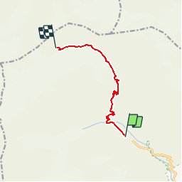
![](/images/other/stat-length.png)
![Tocht Stappen Vallouise-Pelvoux - REFUGE DES ECRINS.01 10 13 - Photo](https://media.geolcdn.com/t/1900/400/ext.pjpeg?maxdim=2&url=https%3A%2F%2Fstatic1.geolcdn.com%2Fsiteimages%2Fupload%2Ffiles%2F1553511878bg_sport_marche.png)
REFUGE DES ECRINS.01 10 13
Dervalmarc
Gebruiker
![Lengte](/images/other/stat-length.png)
![Max. hoogte](https://static1.geolcdn.com/siteimages/upload/files/1508320355ic_sort_altitude_max_24dp.png)
![Positief hoogteverschil](https://static1.geolcdn.com/siteimages/upload/files/1508320355ic_sort_den_pos_24dp.png)
![Km-Effort](/images/other/stat-length.png)
![Min. hoogte](https://static1.geolcdn.com/siteimages/upload/files/1508320355ic_sort_altitude_min_24dp.png)
![Negatief hoogteverschil](https://static1.geolcdn.com/siteimages/upload/files/1508320355ic_sort_den_neg_24dp.png)
![Boucle](https://static1.geolcdn.com/siteimages/upload/files/16400158638029165_repeat_loop_refresh_sync_direction_icon.png)
![Stappen](https://static1.geolcdn.com/sitytour/trail-icons/101.png)
4h45
Moeilijkheid : Moeilijk
![Scan deze QR-code om de tocht te openen in de SityTrail-applicatie](https://capi.geolives.com/qq0zvz2zws4bq2lad0pu/sitytour/trails/762051/qr.png?size=200)
Gratisgps-wandelapplicatie
Over ons
Tocht Stappen van 7,2 km beschikbaar op Provence-Alpes-Côte d'Azur, Hautes-Alpes, Vallouise-Pelvoux. Deze tocht wordt voorgesteld door Dervalmarc.
Beschrijving
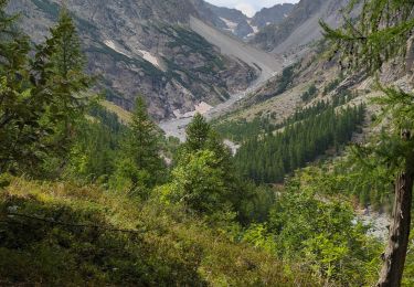
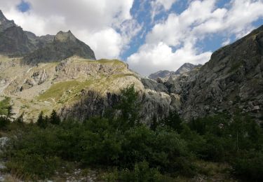
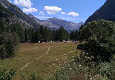
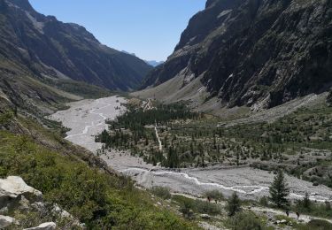
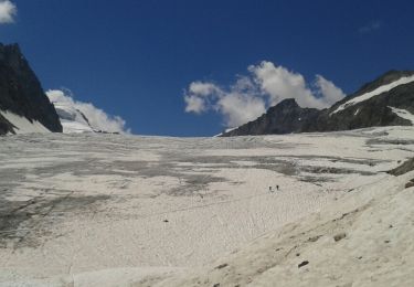
Le refuge des Écrins, appelé aussi refuge Caron est situé sur la commune de Pelvoux, dans le Briançonnais, au cœur du massif des Écrins. Il surplombe le glacier Blanc. Il offre un beau panorama notamment sur la Barre des Écrins.Un grand refuge emblématique situé à 100m environ au dessus du glacier dans un cadre exceptionnel. En fait le sentier est une successions de marque a suivre, un peu comme sur les étapes alpines du GR20. Compter huit a dix heures pour l' aller retour.
Plaatsbepaling
Opmerkingen
Wandeltochten in de omgeving
![Tocht Stappen Vallouise-Pelvoux - traversé du pelvoux - Photo](https://media.geolcdn.com/t/375/260/ext.jpg?maxdim=2&url=https%3A%2F%2Fservices.sitytrail.com%2FGeolivesWS%2FDownloadMedia.ashx%3FTrailID%3D593533%26Media%3Dfix__20160628143021.jpg)
![Stappen Stappen](https://static1.geolcdn.com/sitytour/trail-icons/101.png)
Stappen
![](/images/other/stat-length.png)
![](https://static1.geolcdn.com/siteimages/upload/files/16400158638029165_repeat_loop_refresh_sync_direction_icon.png)
![Tocht Stappen Vallouise-Pelvoux - le refuge glacier blanc et le point de vue sur la barre - Photo](https://media.geolcdn.com/t/375/260/ee7879b1-8037-4c55-8194-cccf54ddc846.jpg&format=jpg&maxdim=2)
![Stappen Stappen](https://static1.geolcdn.com/sitytour/trail-icons/101.png)
Stappen
![](/images/other/stat-length.png)
![](https://static1.geolcdn.com/siteimages/upload/files/16400158638029165_repeat_loop_refresh_sync_direction_icon.png)
![Stappen Stappen](https://static1.geolcdn.com/sitytour/trail-icons/101.png)
Stappen
![](/images/other/stat-length.png)
![](https://static1.geolcdn.com/siteimages/upload/files/16400158638029165_repeat_loop_refresh_sync_direction_icon.png)
![Tocht Stappen Vallouise-Pelvoux - Cascade de Clapouse - Photo](https://media.geolcdn.com/t/375/260/286a2188-66ce-4041-a719-0c298b9ee070.jpg&format=jpg&maxdim=2)
![Stappen Stappen](https://static1.geolcdn.com/sitytour/trail-icons/101.png)
Stappen
![](/images/other/stat-length.png)
![](https://static1.geolcdn.com/siteimages/upload/files/16400158638029165_repeat_loop_refresh_sync_direction_icon.png)
![Tocht Ski randonnée Vallouise-Pelvoux - Le glacier noir - Photo](https://media.geolcdn.com/t/375/260/9edc57a6-e106-44ef-aa2a-0b82165dbf2c.jpg&format=jpg&maxdim=2)
![Ski randonnée Ski randonnée](https://static1.geolcdn.com/sitytour/trail-icons/503.png)
Ski randonnée
![](/images/other/stat-length.png)
![](https://static1.geolcdn.com/siteimages/upload/files/16400158638029165_repeat_loop_refresh_sync_direction_icon.png)
![Tocht Stappen Vallouise-Pelvoux - 05-pre-Mme-Carle-glacier-noir-8km-600m-aout21 - Photo](https://media.geolcdn.com/t/375/260/f2b460db-8baa-455c-9aa4-9129d164ea68.jpg&format=jpg&maxdim=2)
![Stappen Stappen](https://static1.geolcdn.com/sitytour/trail-icons/101.png)
Stappen
![](/images/other/stat-length.png)
![](https://static1.geolcdn.com/siteimages/upload/files/16400158638029165_repeat_loop_refresh_sync_direction_icon.png)
![Tocht Stappen Vallouise-Pelvoux - Source Puiseux - Photo](https://media.geolcdn.com/t/375/260/dabe64c5-d5a8-4a8f-93af-5c262924c5df.jpg&format=jpg&maxdim=2)
![Stappen Stappen](https://static1.geolcdn.com/sitytour/trail-icons/101.png)
Stappen
![](/images/other/stat-length.png)
![](https://static1.geolcdn.com/siteimages/upload/files/16400158638029165_repeat_loop_refresh_sync_direction_icon.png)
![Tocht Stappen Vallouise-Pelvoux - Le Glacier Blanc - Pré Madame Carle - Photo](https://media.geolcdn.com/t/375/260/dec81677-af0a-430c-a892-df5e1d841b58.jpg&format=jpg&maxdim=2)
![Stappen Stappen](https://static1.geolcdn.com/sitytour/trail-icons/101.png)
Stappen
![](/images/other/stat-length.png)
![](https://static1.geolcdn.com/siteimages/upload/files/16400158638029165_repeat_loop_refresh_sync_direction_icon.png)
![Tocht Stappen Vallouise-Pelvoux - Les Écrins jour 2 - Photo](https://media.geolcdn.com/t/375/260/ext.jpg?maxdim=2&url=https%3A%2F%2Fservices.sitytrail.com%2FGeolivesWS%2FDownloadMedia.ashx%3FTrailID%3D1006317%26Media%3Dfix__20180717140759.jpg)
![Stappen Stappen](https://static1.geolcdn.com/sitytour/trail-icons/101.png)
Stappen
![](/images/other/stat-length.png)
![](https://static1.geolcdn.com/siteimages/upload/files/16400158638029165_repeat_loop_refresh_sync_direction_icon.png)