![](/images/other/stat-length.png)
![Tocht Stappen Antrona Schieranco - Italie, Le Lac d'Antrona - Photo](https://media.geolcdn.com/t/1900/400/ext.pjpeg?maxdim=2&url=https%3A%2F%2Fstatic1.geolcdn.com%2Fsiteimages%2Fupload%2Ffiles%2F1553511878bg_sport_marche.png)
Italie, Le Lac d'Antrona
zanogueb
Gebruiker
![Lengte](/images/other/stat-length.png)
![Max. hoogte](https://static1.geolcdn.com/siteimages/upload/files/1508320355ic_sort_altitude_max_24dp.png)
![Positief hoogteverschil](https://static1.geolcdn.com/siteimages/upload/files/1508320355ic_sort_den_pos_24dp.png)
![Km-Effort](/images/other/stat-length.png)
![Min. hoogte](https://static1.geolcdn.com/siteimages/upload/files/1508320355ic_sort_altitude_min_24dp.png)
![Negatief hoogteverschil](https://static1.geolcdn.com/siteimages/upload/files/1508320355ic_sort_den_neg_24dp.png)
![Boucle](https://static1.geolcdn.com/siteimages/upload/files/16400158638029165_repeat_loop_refresh_sync_direction_icon.png)
![Stappen](https://static1.geolcdn.com/sitytour/trail-icons/101.png)
3h11
Moeilijkheid : Medium
![Scan deze QR-code om de tocht te openen in de SityTrail-applicatie](https://capi.geolives.com/qq0zvz2zws4bq2lad0pu/sitytour/trails/757963/qr.png?size=200)
Gratisgps-wandelapplicatie
Over ons
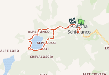
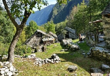
Tocht Stappen van 8,9 km beschikbaar op Piëmont, Verbano-Cusio-Ossola, Antrona Schieranco. Deze tocht wordt voorgesteld door zanogueb.
Beschrijving
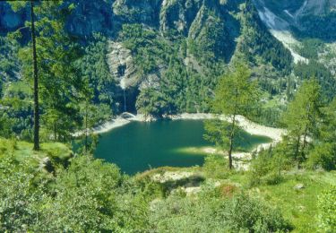
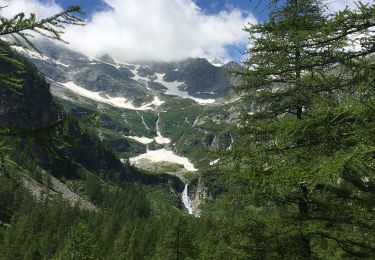
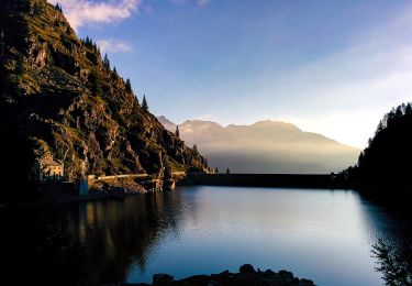
Randonnée à travers un ancien chemin muletier qui reliait la basse vallée d'Ossola à la Suisse. Arrivée au Lac d'Antrona au bord duquel on peut se balader, sa cascade et ses rochers escarpés. Visite du beau village d'Antronapiana, son église et ses maisons en pierre.
Plaatsbepaling
Opmerkingen
Wandeltochten in de omgeving
![Tocht Te voet Antrona Schieranco - C34 - Lago di Campliccioli - Lago di Camposecco - Photo](https://media.geolcdn.com/t/375/260/a3fb9a62-828a-4a1f-906b-e9b1d868c018.jpeg&format=jpg&maxdim=2)
![Te voet Te voet](https://static1.geolcdn.com/sitytour/trail-icons/100.png)
Te voet
![](/images/other/stat-length.png)
![](https://static1.geolcdn.com/siteimages/upload/files/16400158638029165_repeat_loop_refresh_sync_direction_icon.png)
![Tocht Te voet Antrona Schieranco - C23 - Campliccioli, bivio C00 - Alpe Lombraoro sotto, bivio C00 - Photo](https://media.geolcdn.com/t/375/260/a685f981-f3a3-4056-bed4-c124840e7a84.jpeg&format=jpg&maxdim=2)
![Te voet Te voet](https://static1.geolcdn.com/sitytour/trail-icons/100.png)
Te voet
![](/images/other/stat-length.png)
![](https://static1.geolcdn.com/siteimages/upload/files/16400158638029165_repeat_loop_refresh_sync_direction_icon.png)
![Tocht Te voet Antrona Schieranco - C00 - Strada Antronesca tappa 2 - Photo](https://media.geolcdn.com/t/375/260/b43783fe-69f5-48e6-8d34-cf6fddfe72b1.jpeg&format=jpg&maxdim=2)
![Te voet Te voet](https://static1.geolcdn.com/sitytour/trail-icons/100.png)
Te voet
![](/images/other/stat-length.png)
![](https://static1.geolcdn.com/siteimages/upload/files/16400158638029165_repeat_loop_refresh_sync_direction_icon.png)
![Tocht Te voet Antrona Schieranco - C32 - Forcola di Cheggio - Photo](https://media.geolcdn.com/t/375/260/f03de3c7-65c8-450e-9cf9-dbfd39b89ed1.jpeg&format=jpg&maxdim=2)
![Te voet Te voet](https://static1.geolcdn.com/sitytour/trail-icons/100.png)
Te voet
![](/images/other/stat-length.png)
![](https://static1.geolcdn.com/siteimages/upload/files/16400158638029165_repeat_loop_refresh_sync_direction_icon.png)
![Tocht Te voet Antrona Schieranco - C27 - Antronapiana - Bivio C99 (Coronette) - Photo](https://media.geolcdn.com/t/375/260/db5854fd-6672-4dbe-a7a1-dbe0775b01f9.jpeg&format=jpg&maxdim=2)
![Te voet Te voet](https://static1.geolcdn.com/sitytour/trail-icons/100.png)
Te voet
![](/images/other/stat-length.png)
![](https://static1.geolcdn.com/siteimages/upload/files/16400158638029165_repeat_loop_refresh_sync_direction_icon.png)
![Tocht Te voet Antrona Schieranco - (SI E56) Rifugio Città di Novara all'Alpe Cheggio - Rifugio Alpe Laghetto - Photo](https://media.geolcdn.com/t/375/260/287e5399-3c97-472c-8e2e-47aa98750a7e.jpeg&format=jpg&maxdim=2)
![Te voet Te voet](https://static1.geolcdn.com/sitytour/trail-icons/100.png)
Te voet
![](/images/other/stat-length.png)
![](https://static1.geolcdn.com/siteimages/upload/files/16400158638029165_repeat_loop_refresh_sync_direction_icon.png)
![Tocht Te voet Antrona Schieranco - (SI E53N) Rifugio Andolla - Rifugio Alpe Laghetto - Photo](https://media.geolcdn.com/t/375/260/287e5399-3c97-472c-8e2e-47aa98750a7e.jpeg&format=jpg&maxdim=2)
![Te voet Te voet](https://static1.geolcdn.com/sitytour/trail-icons/100.png)
Te voet
![](/images/other/stat-length.png)
![](https://static1.geolcdn.com/siteimages/upload/files/16400158638029165_repeat_loop_refresh_sync_direction_icon.png)
![Tocht Te voet Borgomezzavalle - C96 - da Prato all'Alpe Colma dei Prei - Photo](https://media.geolcdn.com/t/375/260/ext.jpg?maxdim=2&url=https%3A%2F%2Fstatic1.geolcdn.com%2Fsiteimages%2Fupload%2Ffiles%2F1545311037marcheuse_200dpi.jpg)
![Te voet Te voet](https://static1.geolcdn.com/sitytour/trail-icons/100.png)
Te voet
![](/images/other/stat-length.png)
![](https://static1.geolcdn.com/siteimages/upload/files/16400158638029165_repeat_loop_refresh_sync_direction_icon.png)
![Tocht Stappen Antrona Schieranco - antrona - Photo](https://media.geolcdn.com/t/375/260/ext.jpg?maxdim=2&url=https%3A%2F%2Fservices.sitytrail.com%2FGeolivesWS%2FDownloadMedia.ashx%3FTrailID%3D833577%26Media%3Dfix__20170922150827.jpg)
![Stappen Stappen](https://static1.geolcdn.com/sitytour/trail-icons/101.png)
Stappen
![](/images/other/stat-length.png)
![](https://static1.geolcdn.com/siteimages/upload/files/16400158638029165_repeat_loop_refresh_sync_direction_icon.png)