![](/images/other/stat-length.png)
![Tocht Mountainbike Artiguelouve - 1000D+ autour d'Artiguelouve - Photo](https://media.geolcdn.com/t/1900/400/ext.pjpeg?maxdim=2&url=https%3A%2F%2Fstatic1.geolcdn.com%2Fsiteimages%2Fupload%2Ffiles%2F1524743154velo.jpg)
1000D+ autour d'Artiguelouve
mehdih
Gebruiker
![Lengte](/images/other/stat-length.png)
Lengte
40 km
![Max. hoogte](https://static1.geolcdn.com/siteimages/upload/files/1508320355ic_sort_altitude_max_24dp.png)
Max. hoogte
323 m
![Positief hoogteverschil](https://static1.geolcdn.com/siteimages/upload/files/1508320355ic_sort_den_pos_24dp.png)
Positief hoogteverschil
1169 m
![Km-Effort](/images/other/stat-length.png)
Km-Effort
56 km
![Min. hoogte](https://static1.geolcdn.com/siteimages/upload/files/1508320355ic_sort_altitude_min_24dp.png)
Min. hoogte
138 m
![Negatief hoogteverschil](https://static1.geolcdn.com/siteimages/upload/files/1508320355ic_sort_den_neg_24dp.png)
Negatief hoogteverschil
1170 m
![Boucle](https://static1.geolcdn.com/siteimages/upload/files/16400158638029165_repeat_loop_refresh_sync_direction_icon.png)
Boucle
Ja
Datum van aanmaak :
2017-05-21 00:00:00.0
Laatste wijziging :
2017-05-21 00:00:00.0
![Mountainbike](https://static1.geolcdn.com/sitytour/trail-icons/202.png)
3h33
Moeilijkheid : Moeilijk
![Scan deze QR-code om de tocht te openen in de SityTrail-applicatie](https://capi.geolives.com/qq0zvz2zws4bq2lad0pu/sitytour/trails/757297/qr.png?size=200)
Gratisgps-wandelapplicatie
Over ons
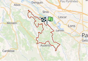
Tocht Mountainbike van 40 km beschikbaar op Nieuw-Aquitanië, Pyrénées-Atlantiques, Artiguelouve. Deze tocht wordt voorgesteld door mehdih.
Beschrijving
Tout passe par temps sec. Démarrer d'Arbus en direction d'Artiguelouve pour un petit échauffement sur la route. Quelques descente un peu technique
Plaatsbepaling
Land:
France
Regio :
Nieuw-Aquitanië
Departement/Provincie :
Pyrénées-Atlantiques
Gemeente :
Artiguelouve
Locatie:
Unknown
Vertrek:(Dec)
Vertrek:(UTM)
704418 ; 4799192 (30T) N.
Opmerkingen
Wandeltochten in de omgeving
![Tocht Te voet Lescar - Lescar du 2018-06-24 - Photo](https://media.geolcdn.com/t/375/260/ext.jpg?maxdim=2&url=https%3A%2F%2Fstatic1.geolcdn.com%2Fsiteimages%2Fupload%2Ffiles%2F1545311037marcheuse_200dpi.jpg)
![Te voet Te voet](https://static1.geolcdn.com/sitytour/trail-icons/100.png)
Lescar du 2018-06-24
Te voet
Heel gemakkelijk
(1)
Lescar,
Nieuw-Aquitanië,
Pyrénées-Atlantiques,
France
![](/images/other/stat-length.png)
7,6 km | 8,6 km-effort
Onbekend
![](https://static1.geolcdn.com/siteimages/upload/files/16400158638029165_repeat_loop_refresh_sync_direction_icon.png)
Ja
![Tocht Stappen Laroin - Les vignes en terrasses des collines de Jurançon - Photo](https://media.geolcdn.com/t/375/260/ext.jpg?maxdim=2&url=https%3A%2F%2Fservices.sitytrail.com%2FGeolivesWS%2FDownloadMedia.ashx%3FTrailID%3D109345%26Media%3D3626_1.jpg)
![Stappen Stappen](https://static1.geolcdn.com/sitytour/trail-icons/101.png)
Les vignes en terrasses des collines de Jurançon
Stappen
Moeilijk
(3)
Laroin,
Nieuw-Aquitanië,
Pyrénées-Atlantiques,
France
![](/images/other/stat-length.png)
19,6 km | 27 km-effort
5h 0min
![](https://static1.geolcdn.com/siteimages/upload/files/16400158638029165_repeat_loop_refresh_sync_direction_icon.png)
Ja
![Tocht Stappen Siros - SIROS Le sentier du gave M2 3143980 - Photo](https://media.geolcdn.com/t/375/260/2adf7da9-eb05-4d5c-bb78-ec6153367b08.jpg&format=jpg&maxdim=2)
![Stappen Stappen](https://static1.geolcdn.com/sitytour/trail-icons/101.png)
SIROS Le sentier du gave M2 3143980
Stappen
Medium
Siros,
Nieuw-Aquitanië,
Pyrénées-Atlantiques,
France
![](/images/other/stat-length.png)
7,9 km | 8,5 km-effort
1h 54min
![](https://static1.geolcdn.com/siteimages/upload/files/16400158638029165_repeat_loop_refresh_sync_direction_icon.png)
Ja
![Tocht Stappen Arbus - ARBUS boucle du bois de bas M2 reco - Photo](https://media.geolcdn.com/t/375/260/0be87ab0-cd88-4f67-aff2-a0f6800a6e9e.jpg&format=jpg&maxdim=2)
![Stappen Stappen](https://static1.geolcdn.com/sitytour/trail-icons/101.png)
ARBUS boucle du bois de bas M2 reco
Stappen
Medium
Arbus,
Nieuw-Aquitanië,
Pyrénées-Atlantiques,
France
![](/images/other/stat-length.png)
7,9 km | 11,2 km-effort
2h 42min
![](https://static1.geolcdn.com/siteimages/upload/files/16400158638029165_repeat_loop_refresh_sync_direction_icon.png)
Ja
![Tocht Stappen Aubertin - AUBERTIN (PPT) de la hélère à la baïse fait (G3) 2641287 - Photo](https://media.geolcdn.com/t/375/260/48e70064-c312-4418-ae56-e61cd12d160d.jpg&format=jpg&maxdim=2)
![Stappen Stappen](https://static1.geolcdn.com/sitytour/trail-icons/101.png)
AUBERTIN (PPT) de la hélère à la baïse fait (G3) 2641287
Stappen
Gemakkelijk
Aubertin,
Nieuw-Aquitanië,
Pyrénées-Atlantiques,
France
![](/images/other/stat-length.png)
12 km | 17,1 km-effort
3h 13min
![](https://static1.geolcdn.com/siteimages/upload/files/16400158638029165_repeat_loop_refresh_sync_direction_icon.png)
Ja
![Tocht Stappen Arbus - ARBUS Le cap d Arrandes N° 47 balisage et signaletique verticale fait le 15/09/2020 - Photo](https://media.geolcdn.com/t/375/260/a2e3dbf3-d618-45af-b80f-84d7f5133529.jpg&format=jpg&maxdim=2)
![Stappen Stappen](https://static1.geolcdn.com/sitytour/trail-icons/101.png)
ARBUS Le cap d Arrandes N° 47 balisage et signaletique verticale fait le 15/0...
Stappen
Gemakkelijk
Arbus,
Nieuw-Aquitanië,
Pyrénées-Atlantiques,
France
![](/images/other/stat-length.png)
4 km | 5,9 km-effort
2h 33min
![](https://static1.geolcdn.com/siteimages/upload/files/16400158638029165_repeat_loop_refresh_sync_direction_icon.png)
Ja
![Tocht Mountainbike Aussevielle - siros labastide aussevielle - Photo](https://media.geolcdn.com/t/375/260/ext.jpg?maxdim=2&url=https%3A%2F%2Fstatic1.geolcdn.com%2Fsiteimages%2Fupload%2Ffiles%2F1524743154velo.jpg)
![Mountainbike Mountainbike](https://static1.geolcdn.com/sitytour/trail-icons/202.png)
siros labastide aussevielle
Mountainbike
Gemakkelijk
(1)
Aussevielle,
Nieuw-Aquitanië,
Pyrénées-Atlantiques,
France
![](/images/other/stat-length.png)
15,6 km | 16,5 km-effort
1h 5min
![](https://static1.geolcdn.com/siteimages/upload/files/16400158638029165_repeat_loop_refresh_sync_direction_icon.png)
Ja
![Tocht Stappen Artiguelouve - ARTIGUELOUVE LA COMMANDE GR653 G4 - Photo](https://media.geolcdn.com/t/375/260/0eb1058d-00a5-4625-be32-6d5c177b89e3.jpg&format=jpg&maxdim=2)
![Stappen Stappen](https://static1.geolcdn.com/sitytour/trail-icons/101.png)
ARTIGUELOUVE LA COMMANDE GR653 G4
Stappen
Medium
Artiguelouve,
Nieuw-Aquitanië,
Pyrénées-Atlantiques,
France
![](/images/other/stat-length.png)
8,4 km | 11 km-effort
2h 29min
![](https://static1.geolcdn.com/siteimages/upload/files/16400158638029165_repeat_loop_refresh_sync_direction_icon.png)
Neen
![Tocht Stappen Lescar - LESCAR de la cité à la nature - Photo](https://media.geolcdn.com/t/375/260/09f39b31-0390-4115-b173-071187e7d734.jpg&format=jpg&maxdim=2)
![Stappen Stappen](https://static1.geolcdn.com/sitytour/trail-icons/101.png)
LESCAR de la cité à la nature
Stappen
Medium
Lescar,
Nieuw-Aquitanië,
Pyrénées-Atlantiques,
France
![](/images/other/stat-length.png)
7,7 km | 8,6 km-effort
1h 59min
![](https://static1.geolcdn.com/siteimages/upload/files/16400158638029165_repeat_loop_refresh_sync_direction_icon.png)
Ja