![](/images/other/stat-length.png)
![Tocht Stappen Riemst - GR 5 : Vroenhoven > Visé - Photo](https://media.geolcdn.com/t/1900/400/ext.pjpeg?maxdim=2&url=https%3A%2F%2Fstatic1.geolcdn.com%2Fsiteimages%2Fupload%2Ffiles%2F1553511878bg_sport_marche.png)
GR 5 : Vroenhoven > Visé
jojolemarcheur
Gebruiker
![Lengte](/images/other/stat-length.png)
Lengte
23 km
![Max. hoogte](https://static1.geolcdn.com/siteimages/upload/files/1508320355ic_sort_altitude_max_24dp.png)
Max. hoogte
148 m
![Positief hoogteverschil](https://static1.geolcdn.com/siteimages/upload/files/1508320355ic_sort_den_pos_24dp.png)
Positief hoogteverschil
318 m
![Km-Effort](/images/other/stat-length.png)
Km-Effort
27 km
![Min. hoogte](https://static1.geolcdn.com/siteimages/upload/files/1508320355ic_sort_altitude_min_24dp.png)
Min. hoogte
53 m
![Negatief hoogteverschil](https://static1.geolcdn.com/siteimages/upload/files/1508320355ic_sort_den_neg_24dp.png)
Negatief hoogteverschil
348 m
![Boucle](https://static1.geolcdn.com/siteimages/upload/files/16400158638029165_repeat_loop_refresh_sync_direction_icon.png)
Boucle
Neen
Datum van aanmaak :
2017-05-18 00:00:00.0
Laatste wijziging :
2017-05-18 00:00:00.0
![Stappen](https://static1.geolcdn.com/sitytour/trail-icons/101.png)
5h56
Moeilijkheid : Medium
![Scan deze QR-code om de tocht te openen in de SityTrail-applicatie](https://capi.geolives.com/qq0zvz2zws4bq2lad0pu/sitytour/trails/755177/qr.png?size=200)
Gratisgps-wandelapplicatie
Over ons
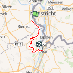
Tocht Stappen van 23 km beschikbaar op Vlaanderen, Limburg, Riemst. Deze tocht wordt voorgesteld door jojolemarcheur.
Beschrijving
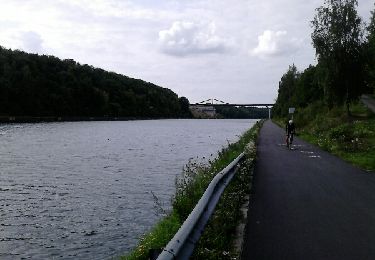
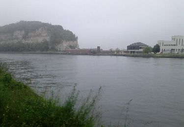
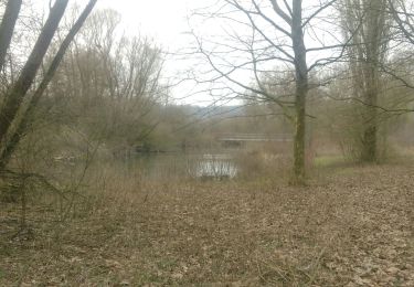
Le GR 5 commence réellement à Kanne, ayant déja randonné sur une autre étape de Vroehoven à Kanne (voir Ketsingen > Eben-Emael), j'ai coupé au court de Vroenhoven à Kanne (4 km). Le tronçon est un peu plus vallonné mais réel difficulté.
Plaatsbepaling
Land:
Belgium
Regio :
Vlaanderen
Departement/Provincie :
Limburg
Gemeente :
Riemst
Locatie:
Vroenhoven
Vertrek:(Dec)
Vertrek:(UTM)
685810 ; 5634146 (31U) N.
Opmerkingen
Wandeltochten in de omgeving
![Tocht Stappen Riemst - 2023-08-16_09h58m46_1192.gpx.xml - Photo](https://media.geolcdn.com/t/375/260/63b86f10-f314-488d-80d4-00787e3a9126.jpg&format=jpg&maxdim=2)
![Stappen Stappen](https://static1.geolcdn.com/sitytour/trail-icons/101.png)
2023-08-16_09h58m46_1192.gpx.xml
Stappen
Medium
(1)
Riemst,
Vlaanderen,
Limburg,
Belgium
![](/images/other/stat-length.png)
5,4 km | 6,7 km-effort
1h 30min
![](https://static1.geolcdn.com/siteimages/upload/files/16400158638029165_repeat_loop_refresh_sync_direction_icon.png)
Ja
![Tocht Stappen Maastricht - Maastricht - Hoge Fronten & 't Bassin - Photo](https://media.geolcdn.com/t/375/260/0d1db1de-c9bf-433a-9df4-c07031a55999.jpg&format=jpg&maxdim=2)
![Stappen Stappen](https://static1.geolcdn.com/sitytour/trail-icons/101.png)
Maastricht - Hoge Fronten & 't Bassin
Stappen
Gemakkelijk
(1)
Maastricht,
Limburg,
Onbekend,
Netherlands
![](/images/other/stat-length.png)
7,7 km | 8,5 km-effort
2h 3min
![](https://static1.geolcdn.com/siteimages/upload/files/16400158638029165_repeat_loop_refresh_sync_direction_icon.png)
Ja
![Tocht Stappen Maastricht - 2022-07-06_09h30m07_1540 - Photo](https://media.geolcdn.com/t/375/260/8e415027-26b4-4bc6-9623-75f03f38b59c.jpg&format=jpg&maxdim=2)
![Stappen Stappen](https://static1.geolcdn.com/sitytour/trail-icons/101.png)
2022-07-06_09h30m07_1540
Stappen
Gemakkelijk
(1)
Maastricht,
Limburg,
Onbekend,
Netherlands
![](/images/other/stat-length.png)
8,7 km | 10,6 km-effort
2h 24min
![](https://static1.geolcdn.com/siteimages/upload/files/16400158638029165_repeat_loop_refresh_sync_direction_icon.png)
Ja
![Tocht Stappen Maastricht - 2022-06-10_16h16m23_1459 - Photo](https://media.geolcdn.com/t/375/260/bd8acbf6-ee38-4b48-89c0-97eec4bf77bd.jpg&format=jpg&maxdim=2)
![Stappen Stappen](https://static1.geolcdn.com/sitytour/trail-icons/101.png)
2022-06-10_16h16m23_1459
Stappen
Gemakkelijk
(1)
Maastricht,
Limburg,
Onbekend,
Netherlands
![](/images/other/stat-length.png)
6,9 km | 7,6 km-effort
1h 44min
![](https://static1.geolcdn.com/siteimages/upload/files/16400158638029165_repeat_loop_refresh_sync_direction_icon.png)
Ja
![Tocht Fiets Riemst - kanne-Maastricht - Photo](https://media.geolcdn.com/t/375/260/ext.jpg?maxdim=2&url=https%3A%2F%2Fservices.sitytrail.com%2FGeolivesWS%2FDownloadMedia.ashx%3FTrailID%3D814135%26Media%3Dfix__20170820172457.jpg)
![Fiets Fiets](https://static1.geolcdn.com/sitytour/trail-icons/200.png)
kanne-Maastricht
Fiets
Gemakkelijk
(1)
Riemst,
Vlaanderen,
Limburg,
Belgium
![](/images/other/stat-length.png)
23 km | 27 km-effort
2h 51min
![](https://static1.geolcdn.com/siteimages/upload/files/16400158638029165_repeat_loop_refresh_sync_direction_icon.png)
Ja
![Tocht Stappen Wezet - autour d eben - Photo](https://media.geolcdn.com/t/375/260/ext.jpg?maxdim=2&url=https%3A%2F%2Fservices.sitytrail.com%2FGeolivesWS%2FDownloadMedia.ashx%3FTrailID%3D579578%26Media%3Dfix__20160604122113.jpg)
![Stappen Stappen](https://static1.geolcdn.com/sitytour/trail-icons/101.png)
autour d eben
Stappen
Gemakkelijk
(1)
Wezet,
Wallonië,
Luik,
Belgium
![](/images/other/stat-length.png)
9 km | 11,7 km-effort
2h 21min
![](https://static1.geolcdn.com/siteimages/upload/files/16400158638029165_repeat_loop_refresh_sync_direction_icon.png)
Ja
![Tocht Stappen Riemst - autour de Kanne - Photo](https://media.geolcdn.com/t/375/260/7f636a39-ab15-4e71-b9b8-cfa2fe7a764e.jpg&format=jpg&maxdim=2)
![Stappen Stappen](https://static1.geolcdn.com/sitytour/trail-icons/101.png)
autour de Kanne
Stappen
Heel gemakkelijk
(1)
Riemst,
Vlaanderen,
Limburg,
Belgium
![](/images/other/stat-length.png)
8,4 km | 10,1 km-effort
2h 46min
![](https://static1.geolcdn.com/siteimages/upload/files/16400158638029165_repeat_loop_refresh_sync_direction_icon.png)
Ja
![Tocht Stappen Riemst - montagne saint Pierre sud par les petits chemins - Photo](https://media.geolcdn.com/t/375/260/f0fd7130-b40c-4dca-9b35-30478d01fde9.jpg&format=jpg&maxdim=2)
![Stappen Stappen](https://static1.geolcdn.com/sitytour/trail-icons/101.png)
montagne saint Pierre sud par les petits chemins
Stappen
Gemakkelijk
(1)
Riemst,
Vlaanderen,
Limburg,
Belgium
![](/images/other/stat-length.png)
7 km | 8,9 km-effort
2h 1min
![](https://static1.geolcdn.com/siteimages/upload/files/16400158638029165_repeat_loop_refresh_sync_direction_icon.png)
Ja
![Tocht Stappen Eijsden-Margraten - Oost Marland - Photo](https://media.geolcdn.com/t/375/260/f6edad86-62e1-4826-85ca-343d9dc4d20e.jpg&format=jpg&maxdim=2)
![Stappen Stappen](https://static1.geolcdn.com/sitytour/trail-icons/101.png)
Oost Marland
Stappen
Heel gemakkelijk
(1)
Eijsden-Margraten,
Limburg,
Onbekend,
Netherlands
![](/images/other/stat-length.png)
3,9 km | 4,1 km-effort
41min
![](https://static1.geolcdn.com/siteimages/upload/files/16400158638029165_repeat_loop_refresh_sync_direction_icon.png)
Ja