![](/images/other/stat-length.png)
![Tocht Stappen Rives-en-Seine - St-Wandrille-Rançon F 2016-05-18 PT - 7KM - Photo](https://media.geolcdn.com/t/1900/400/ext.pjpeg?maxdim=2&url=https%3A%2F%2Fstatic1.geolcdn.com%2Fsiteimages%2Fupload%2Ffiles%2F1553511878bg_sport_marche.png)
St-Wandrille-Rançon F 2016-05-18 PT - 7KM
philippe76
Gebruiker
![Lengte](/images/other/stat-length.png)
![Max. hoogte](https://static1.geolcdn.com/siteimages/upload/files/1508320355ic_sort_altitude_max_24dp.png)
![Positief hoogteverschil](https://static1.geolcdn.com/siteimages/upload/files/1508320355ic_sort_den_pos_24dp.png)
![Km-Effort](/images/other/stat-length.png)
![Min. hoogte](https://static1.geolcdn.com/siteimages/upload/files/1508320355ic_sort_altitude_min_24dp.png)
![Negatief hoogteverschil](https://static1.geolcdn.com/siteimages/upload/files/1508320355ic_sort_den_neg_24dp.png)
![Boucle](https://static1.geolcdn.com/siteimages/upload/files/16400158638029165_repeat_loop_refresh_sync_direction_icon.png)
![Stappen](https://static1.geolcdn.com/sitytour/trail-icons/101.png)
2h02
Moeilijkheid : Medium
![Scan deze QR-code om de tocht te openen in de SityTrail-applicatie](https://capi.geolives.com/qq0zvz2zws4bq2lad0pu/sitytour/trails/746179/qr.png?size=200)
Gratisgps-wandelapplicatie
Over ons
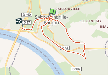
Tocht Stappen van 7,4 km beschikbaar op Normandië, Seine-Maritime, Rives-en-Seine. Deze tocht wordt voorgesteld door philippe76.
Beschrijving
Départ au niveau du PKG de St-Wandrille-Rançon.Prendre AD Rue de la Coutume, TD, AG Chemin du Relais. AG au Pylone, suivre le GR2, TD jusqu'à la rte ftière de Caudebecquetet la prendre AD, Premier chemin AG, TD, AD sur la D64 puis AG rte des Communaux, puis AG et Tjours TD Chemin des barreaux bleux. Terminer par la sente de la messe. au village AD et AG, puis devant l'Abbaye prendre le chemin AG et suivre la rivière la Fontenelle. TD, AD, AG, AD et TD vers la rte de Rannçon, puis arrivée PKG du restaurant les 3 vikings..
Plaatsbepaling
Opmerkingen
Wandeltochten in de omgeving
![Tocht Stappen Rives-en-Seine - saint marguerite sur duclair - Photo](https://media.geolcdn.com/t/375/260/e79a805c-23a8-4b82-8445-cd3cb02d88fd.jpg&format=jpg&maxdim=2)
![Stappen Stappen](https://static1.geolcdn.com/sitytour/trail-icons/101.png)
Stappen
![](/images/other/stat-length.png)
![](https://static1.geolcdn.com/siteimages/upload/files/16400158638029165_repeat_loop_refresh_sync_direction_icon.png)
![Tocht Stappen Notre-Dame-de-Bliquetuit - Notre Dame de Bliquetuit vers l'Armada 18km -sans photos - Photo](https://media.geolcdn.com/t/375/260/70cbc6b4-289e-4f31-9eb1-cafb40f9cb50.jpg&format=jpg&maxdim=2)
![Stappen Stappen](https://static1.geolcdn.com/sitytour/trail-icons/101.png)
Stappen
![](/images/other/stat-length.png)
![](https://static1.geolcdn.com/siteimages/upload/files/16400158638029165_repeat_loop_refresh_sync_direction_icon.png)
![Tocht Stappen Notre-Dame-de-Bliquetuit - Notre Dame de Bliquetuit vers l'Armada 18km - Photo](https://media.geolcdn.com/t/375/260/70cbc6b4-289e-4f31-9eb1-cafb40f9cb50.jpg&format=jpg&maxdim=2)
![Stappen Stappen](https://static1.geolcdn.com/sitytour/trail-icons/101.png)
Stappen
![](/images/other/stat-length.png)
![](https://static1.geolcdn.com/siteimages/upload/files/16400158638029165_repeat_loop_refresh_sync_direction_icon.png)
![Tocht Stappen Rives-en-Seine - saint wandrille 76 - Photo](https://media.geolcdn.com/t/375/260/93ae6a7b-c754-44fd-a552-6b50bdaf0db6.jpg&format=jpg&maxdim=2)
![Stappen Stappen](https://static1.geolcdn.com/sitytour/trail-icons/101.png)
Stappen
![](/images/other/stat-length.png)
![](https://static1.geolcdn.com/siteimages/upload/files/16400158638029165_repeat_loop_refresh_sync_direction_icon.png)
![Stappen Stappen](https://static1.geolcdn.com/sitytour/trail-icons/101.png)
Stappen
![](/images/other/stat-length.png)
![](https://static1.geolcdn.com/siteimages/upload/files/16400158638029165_repeat_loop_refresh_sync_direction_icon.png)
![Tocht Stappen Notre-Dame-de-Bliquetuit - Notre Dame de Bliquetuit - Photo](https://media.geolcdn.com/t/375/260/ext.jpg?maxdim=2&url=https%3A%2F%2Fservices.sitytrail.com%2FGeolivesWS%2FDownloadMedia.ashx%3FTrailID%3D1136395%26Media%3Dfix__20190418180542.jpg)
![Stappen Stappen](https://static1.geolcdn.com/sitytour/trail-icons/101.png)
Stappen
![](/images/other/stat-length.png)
![](https://static1.geolcdn.com/siteimages/upload/files/16400158638029165_repeat_loop_refresh_sync_direction_icon.png)
![Tocht Stappen Arelaune-en-Seine - Saint-Nicolas de Bliquetuit (Vers l'Armada) - Photo](https://media.geolcdn.com/t/375/260/ext.jpg?maxdim=2&url=https%3A%2F%2Fservices.sitytrail.com%2FGeolivesWS%2FDownloadMedia.ashx%3FTrailID%3D1136283%26Media%3Dfix__20190418123539.jpg)
![Stappen Stappen](https://static1.geolcdn.com/sitytour/trail-icons/101.png)
Stappen
![](/images/other/stat-length.png)
![](https://static1.geolcdn.com/siteimages/upload/files/16400158638029165_repeat_loop_refresh_sync_direction_icon.png)
![Tocht Stappen Arelaune-en-Seine - La MAILLERAYE 9 km - Photo](https://media.geolcdn.com/t/375/260/ext.jpg?maxdim=2&url=https%3A%2F%2Fservices.sitytrail.com%2FGeolivesWS%2FDownloadMedia.ashx%3FTrailID%3D1133881%26Media%3Dfix__20190411160150.jpg)
![Stappen Stappen](https://static1.geolcdn.com/sitytour/trail-icons/101.png)
Stappen
![](/images/other/stat-length.png)
![](https://static1.geolcdn.com/siteimages/upload/files/16400158638029165_repeat_loop_refresh_sync_direction_icon.png)