![](/images/other/stat-length.png)
![Tocht Fiets Sedan - J7_nord_velo2017 - Photo](https://media.geolcdn.com/t/1900/400/ext.pjpeg?maxdim=2&url=https%3A%2F%2Fstatic1.geolcdn.com%2Fsiteimages%2Fupload%2Ffiles%2F1524743154velo.jpg)
J7_nord_velo2017
FABLUK
Gebruiker
![Lengte](/images/other/stat-length.png)
Lengte
83 km
![Max. hoogte](https://static1.geolcdn.com/siteimages/upload/files/1508320355ic_sort_altitude_max_24dp.png)
Max. hoogte
274 m
![Positief hoogteverschil](https://static1.geolcdn.com/siteimages/upload/files/1508320355ic_sort_den_pos_24dp.png)
Positief hoogteverschil
819 m
![Km-Effort](/images/other/stat-length.png)
Km-Effort
94 km
![Min. hoogte](https://static1.geolcdn.com/siteimages/upload/files/1508320355ic_sort_altitude_min_24dp.png)
Min. hoogte
149 m
![Negatief hoogteverschil](https://static1.geolcdn.com/siteimages/upload/files/1508320355ic_sort_den_neg_24dp.png)
Negatief hoogteverschil
771 m
![Boucle](https://static1.geolcdn.com/siteimages/upload/files/16400158638029165_repeat_loop_refresh_sync_direction_icon.png)
Boucle
Neen
Datum van aanmaak :
2017-04-14 00:00:00.0
Laatste wijziging :
2017-04-14 00:00:00.0
![Fiets](https://static1.geolcdn.com/sitytour/trail-icons/200.png)
5h21
Moeilijkheid : Zeer moeilijk
![Scan deze QR-code om de tocht te openen in de SityTrail-applicatie](https://capi.geolives.com/qq0zvz2zws4bq2lad0pu/sitytour/trails/732572/qr.png?size=200)
Gratisgps-wandelapplicatie
Over ons
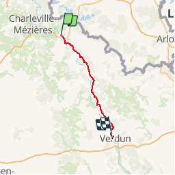
Tocht Fiets van 83 km beschikbaar op Grand Est, Ardennes, Sedan. Deze tocht wordt voorgesteld door FABLUK.
Beschrijving
départ: 33, rue des Fausses Braies 08200 SEDAN Port : 06 66 18 78 26 Mail : michel.kaurin@gmail.com
Arrivée: Camping les Breuils
8 allée des Breuils
55100 VERDUN
Tél : 03.29.86.15.31
Plaatsbepaling
Land:
France
Regio :
Grand Est
Departement/Provincie :
Ardennes
Gemeente :
Sedan
Locatie:
Unknown
Vertrek:(Dec)
Vertrek:(UTM)
640466 ; 5506836 (31U) N.
Opmerkingen
Wandeltochten in de omgeving
![Tocht Stappen Illy - Chemin des contrebandiers - Illy - Photo](https://media.geolcdn.com/t/375/260/ext.jpg?maxdim=2&url=https%3A%2F%2Fservices.sitytrail.com%2FGeolivesWS%2FDownloadMedia.ashx%3FTrailID%3D191646%26Media%3D15295_6.jpg)
![Stappen Stappen](https://static1.geolcdn.com/sitytour/trail-icons/101.png)
Chemin des contrebandiers - Illy
Stappen
Gemakkelijk
(2)
Illy,
Grand Est,
Ardennes,
France
![](/images/other/stat-length.png)
7,9 km | 9,9 km-effort
1h 55min
![](https://static1.geolcdn.com/siteimages/upload/files/16400158638029165_repeat_loop_refresh_sync_direction_icon.png)
Ja
![Tocht Stappen Wadelincourt - Wadelincourt - Photo](https://media.geolcdn.com/t/375/260/ext.jpg?maxdim=2&url=https%3A%2F%2Fmedia.geolcdn.com%2Ff%2Fee2ba9dc-7995-4193-9379-32cae1d5edd4.jpg)
![Stappen Stappen](https://static1.geolcdn.com/sitytour/trail-icons/101.png)
Wadelincourt
Stappen
Medium
Wadelincourt,
Grand Est,
Ardennes,
France
![](/images/other/stat-length.png)
18,9 km | 25 km-effort
5h 5min
![](https://static1.geolcdn.com/siteimages/upload/files/16400158638029165_repeat_loop_refresh_sync_direction_icon.png)
Ja
![Tocht Mountainbike Sedan - 20191006 Yeyette sur la voie verte à Sedan - Photo](https://media.geolcdn.com/t/375/260/ext.jpg?maxdim=2&url=https%3A%2F%2Fmedia.geolcdn.com%2Ff%2Fb806c0b7-e370-4e14-9be3-9a414d970f45.jpg)
![Mountainbike Mountainbike](https://static1.geolcdn.com/sitytour/trail-icons/202.png)
20191006 Yeyette sur la voie verte à Sedan
Mountainbike
Sedan,
Grand Est,
Ardennes,
France
![](/images/other/stat-length.png)
37 km | 44 km-effort
6h 23min
![](https://static1.geolcdn.com/siteimages/upload/files/16400158638029165_repeat_loop_refresh_sync_direction_icon.png)
Ja
![Tocht Noords wandelen Saint-Menges - Saint Menges FFSP 4/9/22 - Photo](https://media.geolcdn.com/t/375/260/ext.jpg?maxdim=2&url=https%3A%2F%2Fmedia.geolcdn.com%2Ff%2F339f7c0f-af9f-4f5e-ac04-2167c1aa5322.jpg)
![Noords wandelen Noords wandelen](https://static1.geolcdn.com/sitytour/trail-icons/102.png)
Saint Menges FFSP 4/9/22
Noords wandelen
Moeilijk
Saint-Menges,
Grand Est,
Ardennes,
France
![](/images/other/stat-length.png)
21 km | 27 km-effort
3h 17min
![](https://static1.geolcdn.com/siteimages/upload/files/16400158638029165_repeat_loop_refresh_sync_direction_icon.png)
Ja
![Tocht Te voet Illy - Sentier du Bois Talot - Photo](https://media.geolcdn.com/t/375/260/ext.jpg?maxdim=2&url=https%3A%2F%2Fmedia.geolcdn.com%2Ff%2Fa43e25ae-69e9-4769-9a1d-35acca2d449f.jpeg)
![Te voet Te voet](https://static1.geolcdn.com/sitytour/trail-icons/100.png)
Sentier du Bois Talot
Te voet
Gemakkelijk
Illy,
Grand Est,
Ardennes,
France
![](/images/other/stat-length.png)
7,9 km | 10 km-effort
2h 15min
![](https://static1.geolcdn.com/siteimages/upload/files/16400158638029165_repeat_loop_refresh_sync_direction_icon.png)
Ja
![Tocht Stappen Givonne - FORÊT DE GIVONNES - Photo](https://media.geolcdn.com/t/375/260/ext.jpg?maxdim=2&url=https%3A%2F%2Fservices.sitytrail.com%2FGeolivesWS%2FDownloadMedia.ashx%3FTrailID%3D988272%26Media%3D20180617161357.jpg)
![Stappen Stappen](https://static1.geolcdn.com/sitytour/trail-icons/101.png)
FORÊT DE GIVONNES
Stappen
Gemakkelijk
Givonne,
Grand Est,
Ardennes,
France
![](/images/other/stat-length.png)
11,6 km | 14,6 km-effort
3h 26min
![](https://static1.geolcdn.com/siteimages/upload/files/16400158638029165_repeat_loop_refresh_sync_direction_icon.png)
Ja
![Tocht Stappen Illy - Le sentier du bois Talot - Photo](https://media.geolcdn.com/t/375/260/ext.jpg?maxdim=2&url=https%3A%2F%2Fservices.sitytrail.com%2FGeolivesWS%2FDownloadMedia.ashx%3FTrailID%3D309421%26Media%3D20140605122832.jpg)
![Stappen Stappen](https://static1.geolcdn.com/sitytour/trail-icons/101.png)
Le sentier du bois Talot
Stappen
Heel gemakkelijk
Illy,
Grand Est,
Ardennes,
France
![](/images/other/stat-length.png)
9,3 km | 11,7 km-effort
2h 16min
![](https://static1.geolcdn.com/siteimages/upload/files/16400158638029165_repeat_loop_refresh_sync_direction_icon.png)
Ja
![Tocht Mountainbike Givonne - Espace VTT FFC Pays Sedanais Le Banet - Circuit n° 12 - Photo](https://media.geolcdn.com/t/375/260/ext.jpg?maxdim=2&url=https%3A%2F%2Fservices.sitytrail.com%2FGeolivesWS%2FDownloadMedia.ashx%3FTrailID%3D102283%26Media%3D2744_1.jpg)
![Mountainbike Mountainbike](https://static1.geolcdn.com/sitytour/trail-icons/202.png)
Espace VTT FFC Pays Sedanais Le Banet - Circuit n° 12
Mountainbike
Moeilijk
Givonne,
Grand Est,
Ardennes,
France
![](/images/other/stat-length.png)
40 km | 51 km-effort
4h 0min
![](https://static1.geolcdn.com/siteimages/upload/files/16400158638029165_repeat_loop_refresh_sync_direction_icon.png)
Ja
![Tocht Mountainbike Givonne - Espace VTT FFC Pays Sedanais Le Banet - Circuit n° 11 - Photo](https://media.geolcdn.com/t/375/260/ext.jpg?maxdim=2&url=https%3A%2F%2Fservices.sitytrail.com%2FGeolivesWS%2FDownloadMedia.ashx%3FTrailID%3D102282%26Media%3D2743_1.jpg)
![Mountainbike Mountainbike](https://static1.geolcdn.com/sitytour/trail-icons/202.png)
Espace VTT FFC Pays Sedanais Le Banet - Circuit n° 11
Mountainbike
Moeilijk
(1)
Givonne,
Grand Est,
Ardennes,
France
![](/images/other/stat-length.png)
35 km | 43 km-effort
3h 0min
![](https://static1.geolcdn.com/siteimages/upload/files/16400158638029165_repeat_loop_refresh_sync_direction_icon.png)
Ja