![](/images/other/stat-length.png)
![Tocht Stappen Montrollet - Montrollet boucle du rocher aux oiseaux - Photo](https://media.geolcdn.com/t/1900/400/ext.pjpeg?maxdim=2&url=https%3A%2F%2Fservices.sitytrail.com%2FGeolivesWS%2FDownloadMedia.ashx%3FTrailID%3D730803%26Media%3Dfix__20170411153635.jpg)
Montrollet boucle du rocher aux oiseaux
rougilabuse
Gebruiker
![Lengte](/images/other/stat-length.png)
Lengte
16,6 km
![Max. hoogte](https://static1.geolcdn.com/siteimages/upload/files/1508320355ic_sort_altitude_max_24dp.png)
Max. hoogte
367 m
![Positief hoogteverschil](https://static1.geolcdn.com/siteimages/upload/files/1508320355ic_sort_den_pos_24dp.png)
Positief hoogteverschil
263 m
![Km-Effort](/images/other/stat-length.png)
Km-Effort
20 km
![Min. hoogte](https://static1.geolcdn.com/siteimages/upload/files/1508320355ic_sort_altitude_min_24dp.png)
Min. hoogte
257 m
![Negatief hoogteverschil](https://static1.geolcdn.com/siteimages/upload/files/1508320355ic_sort_den_neg_24dp.png)
Negatief hoogteverschil
262 m
![Boucle](https://static1.geolcdn.com/siteimages/upload/files/16400158638029165_repeat_loop_refresh_sync_direction_icon.png)
Boucle
Ja
Datum van aanmaak :
2017-04-11 00:00:00.0
Laatste wijziging :
2017-04-11 00:00:00.0
![Stappen](https://static1.geolcdn.com/sitytour/trail-icons/101.png)
4h25
Moeilijkheid : Medium
![Scan deze QR-code om de tocht te openen in de SityTrail-applicatie](https://capi.geolives.com/qq0zvz2zws4bq2lad0pu/sitytour/trails/730803/qr.png?size=200)
Gratisgps-wandelapplicatie
Over ons
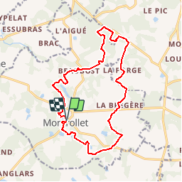
Tocht Stappen van 16,6 km beschikbaar op Nieuw-Aquitanië, Charente, Montrollet. Deze tocht wordt voorgesteld door rougilabuse.
Beschrijving
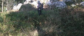
l'altitude maxi du sitytrail est de 366m mais l'altitude du rocher aux oiseaux point culminant du Poitou Charente de368m: c'est le dessus du gros rocher accès difficile.
Plaatsbepaling
Land:
France
Regio :
Nieuw-Aquitanië
Departement/Provincie :
Charente
Gemeente :
Montrollet
Locatie:
Unknown
Vertrek:(Dec)
Vertrek:(UTM)
337088 ; 5094344 (31T) N.
Opmerkingen
Wandeltochten in de omgeving
![Tocht Motor Montrollet - sortie quad - Photo](https://media.geolcdn.com/t/375/260/ext.jpg?maxdim=2&url=https%3A%2F%2Fstatic1.geolcdn.com%2Fsiteimages%2Fupload%2Ffiles%2F15247431544x4.jpg)
![Motor Motor](https://static1.geolcdn.com/sitytour/trail-icons/400.png)
sortie quad
Motor
Gemakkelijk
(2)
Montrollet,
Nieuw-Aquitanië,
Charente,
France
![](/images/other/stat-length.png)
67 km | 78 km-effort
5h 35min
![](https://static1.geolcdn.com/siteimages/upload/files/16400158638029165_repeat_loop_refresh_sync_direction_icon.png)
Neen
![Tocht Stappen Montrollet - montrollet - Photo](https://media.geolcdn.com/t/375/260/ed36749a-45de-4101-8c17-6ca336544293.jpg&format=jpg&maxdim=2)
![Stappen Stappen](https://static1.geolcdn.com/sitytour/trail-icons/101.png)
montrollet
Stappen
Heel gemakkelijk
Montrollet,
Nieuw-Aquitanië,
Charente,
France
![](/images/other/stat-length.png)
9,8 km | 11,2 km-effort
2h 21min
![](https://static1.geolcdn.com/siteimages/upload/files/16400158638029165_repeat_loop_refresh_sync_direction_icon.png)
Ja
![Tocht Motor Montrollet - Ballade Quad - Photo](https://media.geolcdn.com/t/375/260/ext.jpg?maxdim=2&url=https%3A%2F%2Fstatic1.geolcdn.com%2Fsiteimages%2Fupload%2Ffiles%2F15247431544x4.jpg)
![Motor Motor](https://static1.geolcdn.com/sitytour/trail-icons/400.png)
Ballade Quad
Motor
Gemakkelijk
Montrollet,
Nieuw-Aquitanië,
Charente,
France
![](/images/other/stat-length.png)
36 km | 42 km-effort
17h 7min
![](https://static1.geolcdn.com/siteimages/upload/files/16400158638029165_repeat_loop_refresh_sync_direction_icon.png)
Ja
![Tocht Stappen Montrol-Sénard - Salomon Henry IV - Photo](https://media.geolcdn.com/t/375/260/ext.jpg?maxdim=2&url=https%3A%2F%2Fstatic1.geolcdn.com%2Fsiteimages%2Fupload%2Ffiles%2F1553511878bg_sport_marche.png)
![Stappen Stappen](https://static1.geolcdn.com/sitytour/trail-icons/101.png)
Salomon Henry IV
Stappen
Medium
Montrol-Sénard,
Nieuw-Aquitanië,
Haute-Vienne,
France
![](/images/other/stat-length.png)
9,5 km | 12,2 km-effort
2h 14min
![](https://static1.geolcdn.com/siteimages/upload/files/16400158638029165_repeat_loop_refresh_sync_direction_icon.png)
Ja
![Tocht Stappen Brigueuil - Brigueil Montrolet - Photo](https://media.geolcdn.com/t/375/260/ext.jpg?maxdim=2&url=https%3A%2F%2Fstatic1.geolcdn.com%2Fsiteimages%2Fupload%2Ffiles%2F1553511878bg_sport_marche.png)
![Stappen Stappen](https://static1.geolcdn.com/sitytour/trail-icons/101.png)
Brigueil Montrolet
Stappen
Gemakkelijk
Brigueuil,
Nieuw-Aquitanië,
Charente,
France
![](/images/other/stat-length.png)
4,6 km | 5,4 km-effort
1h 15min
![](https://static1.geolcdn.com/siteimages/upload/files/16400158638029165_repeat_loop_refresh_sync_direction_icon.png)
Ja
![Tocht Stappen Brigueuil - Brigueil - Photo](https://media.geolcdn.com/t/375/260/ext.jpg?maxdim=2&url=https%3A%2F%2Fstatic1.geolcdn.com%2Fsiteimages%2Fupload%2Ffiles%2F1553511878bg_sport_marche.png)
![Stappen Stappen](https://static1.geolcdn.com/sitytour/trail-icons/101.png)
Brigueil
Stappen
Gemakkelijk
Brigueuil,
Nieuw-Aquitanië,
Charente,
France
![](/images/other/stat-length.png)
6,7 km | 7,8 km-effort
1h 45min
![](https://static1.geolcdn.com/siteimages/upload/files/16400158638029165_repeat_loop_refresh_sync_direction_icon.png)
Ja
![Tocht Stappen Montrollet - montrollet - Photo](https://media.geolcdn.com/t/375/260/ext.jpg?maxdim=2&url=https%3A%2F%2Fstatic1.geolcdn.com%2Fsiteimages%2Fupload%2Ffiles%2F1553511878bg_sport_marche.png)
![Stappen Stappen](https://static1.geolcdn.com/sitytour/trail-icons/101.png)
montrollet
Stappen
Zeer moeilijk
Montrollet,
Nieuw-Aquitanië,
Charente,
France
![](/images/other/stat-length.png)
18,5 km | 23 km-effort
4h 33min
![](https://static1.geolcdn.com/siteimages/upload/files/16400158638029165_repeat_loop_refresh_sync_direction_icon.png)
Ja
![Tocht Mountainbike Saint-Christophe - T08-Saint-Christophe à Brillac - Photo](https://media.geolcdn.com/t/375/260/ext.jpg?maxdim=2&url=https%3A%2F%2Fstatic1.geolcdn.com%2Fsiteimages%2Fupload%2Ffiles%2F1524743154velo.jpg)
![Mountainbike Mountainbike](https://static1.geolcdn.com/sitytour/trail-icons/202.png)
T08-Saint-Christophe à Brillac
Mountainbike
Heel gemakkelijk
Saint-Christophe,
Nieuw-Aquitanië,
Charente,
France
![](/images/other/stat-length.png)
13,7 km | 16,3 km-effort
Onbekend
![](https://static1.geolcdn.com/siteimages/upload/files/16400158638029165_repeat_loop_refresh_sync_direction_icon.png)
Neen
![Tocht Mountainbike Brigueuil - T07-Brigueuil à Saint-Christophe - Photo](https://media.geolcdn.com/t/375/260/ext.jpg?maxdim=2&url=https%3A%2F%2Fstatic1.geolcdn.com%2Fsiteimages%2Fupload%2Ffiles%2F1524743154velo.jpg)
![Mountainbike Mountainbike](https://static1.geolcdn.com/sitytour/trail-icons/202.png)
T07-Brigueuil à Saint-Christophe
Mountainbike
Heel gemakkelijk
Brigueuil,
Nieuw-Aquitanië,
Charente,
France
![](/images/other/stat-length.png)
20 km | 24 km-effort
Onbekend
![](https://static1.geolcdn.com/siteimages/upload/files/16400158638029165_repeat_loop_refresh_sync_direction_icon.png)
Neen