![](/images/other/stat-length.png)
![Tocht Fiets Cluny - circuit cyclo cluny du 9 avril 2017 jb - Photo](https://media.geolcdn.com/t/1900/400/ext.pjpeg?maxdim=2&url=https%3A%2F%2Fstatic1.geolcdn.com%2Fsiteimages%2Fupload%2Ffiles%2F1524743154velo.jpg)
circuit cyclo cluny du 9 avril 2017 jb
jbsky71
Gebruiker
![Lengte](/images/other/stat-length.png)
Lengte
61 km
![Max. hoogte](https://static1.geolcdn.com/siteimages/upload/files/1508320355ic_sort_altitude_max_24dp.png)
Max. hoogte
542 m
![Positief hoogteverschil](https://static1.geolcdn.com/siteimages/upload/files/1508320355ic_sort_den_pos_24dp.png)
Positief hoogteverschil
857 m
![Km-Effort](/images/other/stat-length.png)
Km-Effort
73 km
![Min. hoogte](https://static1.geolcdn.com/siteimages/upload/files/1508320355ic_sort_altitude_min_24dp.png)
Min. hoogte
232 m
![Negatief hoogteverschil](https://static1.geolcdn.com/siteimages/upload/files/1508320355ic_sort_den_neg_24dp.png)
Negatief hoogteverschil
858 m
![Boucle](https://static1.geolcdn.com/siteimages/upload/files/16400158638029165_repeat_loop_refresh_sync_direction_icon.png)
Boucle
Ja
Datum van aanmaak :
2017-04-05 00:00:00.0
Laatste wijziging :
2017-04-05 00:00:00.0
![Fiets](https://static1.geolcdn.com/sitytour/trail-icons/200.png)
3h00
Moeilijkheid : Medium
![Scan deze QR-code om de tocht te openen in de SityTrail-applicatie](https://capi.geolives.com/qq0zvz2zws4bq2lad0pu/sitytour/trails/727369/qr.png?size=200)
Gratisgps-wandelapplicatie
Over ons
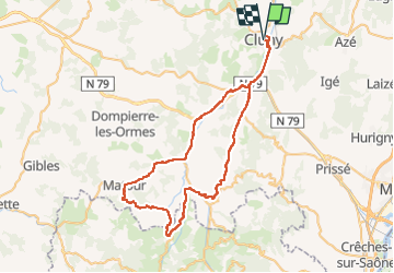
Tocht Fiets van 61 km beschikbaar op Bourgondië-Franche-Comté, Saône-et-Loire, Cluny. Deze tocht wordt voorgesteld door jbsky71.
Beschrijving
Départ cluny 9h00
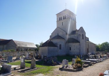
Direction saint-point, tramayes, St Léger sous la Bussière, Saint-christophe,St Pierre le Vieux ,matour, trambly, clermain, st-cécile, cluny.
Plaatsbepaling
Land:
France
Regio :
Bourgondië-Franche-Comté
Departement/Provincie :
Saône-et-Loire
Gemeente :
Cluny
Locatie:
Unknown
Vertrek:(Dec)
Vertrek:(UTM)
627361 ; 5143699 (31T) N.
Opmerkingen
Wandeltochten in de omgeving
![Tocht Stappen Cluny - La marche des Moines, Cluny 2012 - Photo](https://media.geolcdn.com/t/375/260/ext.jpg?maxdim=2&url=https%3A%2F%2Fservices.sitytrail.com%2FGeolivesWS%2FDownloadMedia.ashx%3FTrailID%3D162282%26Media%3D20121111123029.jpg)
![Stappen Stappen](https://static1.geolcdn.com/sitytour/trail-icons/101.png)
La marche des Moines, Cluny 2012
Stappen
Heel gemakkelijk
(1)
Cluny,
Bourgondië-Franche-Comté,
Saône-et-Loire,
France
![](/images/other/stat-length.png)
11,8 km | 16,1 km-effort
3h 14min
![](https://static1.geolcdn.com/siteimages/upload/files/16400158638029165_repeat_loop_refresh_sync_direction_icon.png)
Ja
![Tocht Stappen Donzy-le-Pertuis - Donzy le Perthuis la fontaine des croix page 66 - Photo](https://media.geolcdn.com/t/375/260/a4b0f069-00b6-4a98-988d-c366d01428aa.jpg&format=jpg&maxdim=2)
![Stappen Stappen](https://static1.geolcdn.com/sitytour/trail-icons/101.png)
Donzy le Perthuis la fontaine des croix page 66
Stappen
Zeer moeilijk
(3)
Donzy-le-Pertuis,
Bourgondië-Franche-Comté,
Saône-et-Loire,
France
![](/images/other/stat-length.png)
16,8 km | 23 km-effort
5h 18min
![](https://static1.geolcdn.com/siteimages/upload/files/16400158638029165_repeat_loop_refresh_sync_direction_icon.png)
Ja
![Tocht Te voet Cluny - Cluny Berzé le Chatel Tunnel du bois clair page 160 - Photo](https://media.geolcdn.com/t/375/260/ext.jpg?maxdim=2&url=https%3A%2F%2Fstatic1.geolcdn.com%2Fsiteimages%2Fupload%2Ffiles%2F1545311037marcheuse_200dpi.jpg)
![Te voet Te voet](https://static1.geolcdn.com/sitytour/trail-icons/100.png)
Cluny Berzé le Chatel Tunnel du bois clair page 160
Te voet
Medium
(1)
Cluny,
Bourgondië-Franche-Comté,
Saône-et-Loire,
France
![](/images/other/stat-length.png)
18,5 km | 26 km-effort
4h 41min
![](https://static1.geolcdn.com/siteimages/upload/files/16400158638029165_repeat_loop_refresh_sync_direction_icon.png)
Ja
![Tocht Elektrische fiets Cluny - Nord est de Cluny - Photo](https://media.geolcdn.com/t/375/260/ext.jpg?maxdim=2&url=https%3A%2F%2Fstatic1.geolcdn.com%2Fsiteimages%2Fupload%2Ffiles%2F1524743154velo.jpg)
![Elektrische fiets Elektrische fiets](https://static1.geolcdn.com/sitytour/trail-icons/205.png)
Nord est de Cluny
Elektrische fiets
Medium
(1)
Cluny,
Bourgondië-Franche-Comté,
Saône-et-Loire,
France
![](/images/other/stat-length.png)
43 km | 54 km-effort
4h 0min
![](https://static1.geolcdn.com/siteimages/upload/files/16400158638029165_repeat_loop_refresh_sync_direction_icon.png)
Ja
![Tocht Noords wandelen Lournand - Lournand_MN_G1_validé_29_03_2023 - Photo](https://media.geolcdn.com/t/375/260/ext.jpg?maxdim=2&url=https%3A%2F%2Fstatic1.geolcdn.com%2Fsiteimages%2Fupload%2Ffiles%2F1545311037marcheuse_200dpi.jpg)
![Noords wandelen Noords wandelen](https://static1.geolcdn.com/sitytour/trail-icons/102.png)
Lournand_MN_G1_validé_29_03_2023
Noords wandelen
Moeilijk
(1)
Lournand,
Bourgondië-Franche-Comté,
Saône-et-Loire,
France
![](/images/other/stat-length.png)
12,9 km | 18 km-effort
Onbekend
![](https://static1.geolcdn.com/siteimages/upload/files/16400158638029165_repeat_loop_refresh_sync_direction_icon.png)
Ja
![Tocht Noords wandelen Lournand - Lournand_MN_G2_G3_validé_29_03_2023 - Photo](https://media.geolcdn.com/t/375/260/ext.jpg?maxdim=2&url=https%3A%2F%2Fstatic1.geolcdn.com%2Fsiteimages%2Fupload%2Ffiles%2F1545311037marcheuse_200dpi.jpg)
![Noords wandelen Noords wandelen](https://static1.geolcdn.com/sitytour/trail-icons/102.png)
Lournand_MN_G2_G3_validé_29_03_2023
Noords wandelen
Moeilijk
(4)
Lournand,
Bourgondië-Franche-Comté,
Saône-et-Loire,
France
![](/images/other/stat-length.png)
10,6 km | 14,9 km-effort
Onbekend
![](https://static1.geolcdn.com/siteimages/upload/files/16400158638029165_repeat_loop_refresh_sync_direction_icon.png)
Ja
![Tocht Stappen Cluny - Cluny Rando des moines - Photo](https://media.geolcdn.com/t/375/260/bc5a470b-37f6-4245-a631-4a1a06dbb825.jpg&format=jpg&maxdim=2)
![Stappen Stappen](https://static1.geolcdn.com/sitytour/trail-icons/101.png)
Cluny Rando des moines
Stappen
Moeilijk
Cluny,
Bourgondië-Franche-Comté,
Saône-et-Loire,
France
![](/images/other/stat-length.png)
21 km | 28 km-effort
4h 13min
![](https://static1.geolcdn.com/siteimages/upload/files/16400158638029165_repeat_loop_refresh_sync_direction_icon.png)
Ja
![Elektrische fiets Elektrische fiets](https://static1.geolcdn.com/sitytour/trail-icons/205.png)
Boucle Cluny - Malay
Elektrische fiets
Gemakkelijk
Cluny,
Bourgondië-Franche-Comté,
Saône-et-Loire,
France
![](/images/other/stat-length.png)
49 km | 57 km-effort
5h 36min
![](https://static1.geolcdn.com/siteimages/upload/files/16400158638029165_repeat_loop_refresh_sync_direction_icon.png)
Neen
![Elektrische fiets Elektrische fiets](https://static1.geolcdn.com/sitytour/trail-icons/205.png)
Boucle Cluny -Milly Lamartine
Elektrische fiets
Medium
Cluny,
Bourgondië-Franche-Comté,
Saône-et-Loire,
France
![](/images/other/stat-length.png)
37 km | 47 km-effort
4h 41min
![](https://static1.geolcdn.com/siteimages/upload/files/16400158638029165_repeat_loop_refresh_sync_direction_icon.png)
Neen