![](/images/other/stat-length.png)
![Tocht Stappen Clef-Vallée-d'Eure - Ecardenville sur Eure (122) - Photo](https://media.geolcdn.com/t/1900/400/ext.pjpeg?maxdim=2&url=https%3A%2F%2Fstatic1.geolcdn.com%2Fsiteimages%2Fupload%2Ffiles%2F1553511878bg_sport_marche.png)
Ecardenville sur Eure (122)
randovivi
Gebruiker
![Lengte](/images/other/stat-length.png)
Lengte
11,1 km
![Max. hoogte](https://static1.geolcdn.com/siteimages/upload/files/1508320355ic_sort_altitude_max_24dp.png)
Max. hoogte
138 m
![Positief hoogteverschil](https://static1.geolcdn.com/siteimages/upload/files/1508320355ic_sort_den_pos_24dp.png)
Positief hoogteverschil
157 m
![Km-Effort](/images/other/stat-length.png)
Km-Effort
13,2 km
![Min. hoogte](https://static1.geolcdn.com/siteimages/upload/files/1508320355ic_sort_altitude_min_24dp.png)
Min. hoogte
23 m
![Negatief hoogteverschil](https://static1.geolcdn.com/siteimages/upload/files/1508320355ic_sort_den_neg_24dp.png)
Negatief hoogteverschil
158 m
![Boucle](https://static1.geolcdn.com/siteimages/upload/files/16400158638029165_repeat_loop_refresh_sync_direction_icon.png)
Boucle
Ja
Datum van aanmaak :
2017-04-03 00:00:00.0
Laatste wijziging :
2017-04-03 00:00:00.0
![Stappen](https://static1.geolcdn.com/sitytour/trail-icons/101.png)
2h54
Moeilijkheid : Gemakkelijk
![Scan deze QR-code om de tocht te openen in de SityTrail-applicatie](https://capi.geolives.com/qq0zvz2zws4bq2lad0pu/sitytour/trails/726169/qr.png?size=200)
Gratisgps-wandelapplicatie
Over ons
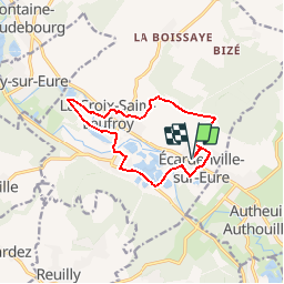
Tocht Stappen van 11,1 km beschikbaar op Normandië, Eure, Clef-Vallée-d'Eure. Deze tocht wordt voorgesteld door randovivi.
Beschrijving
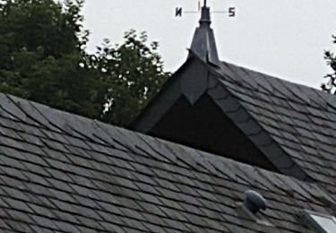
Départ de l'école d'Ecardenville sur Eure (Rue Roger Lefebre) puis direction Crève Coeur puis la croix st. Leufroy et retour Ecardenville
Plaatsbepaling
Land:
France
Regio :
Normandië
Departement/Provincie :
Eure
Gemeente :
Clef-Vallée-d'Eure
Locatie:
Unknown
Vertrek:(Dec)
Vertrek:(UTM)
373390 ; 5440194 (31U) N.
Opmerkingen
Wandeltochten in de omgeving
![Stappen Stappen](https://static1.geolcdn.com/sitytour/trail-icons/101.png)
20240323-La Croix St Leuffroy
Stappen
Medium
Clef-Vallée-d'Eure,
Normandië,
Eure,
France
![](/images/other/stat-length.png)
11,1 km | 13,1 km-effort
3h 22min
![](https://static1.geolcdn.com/siteimages/upload/files/16400158638029165_repeat_loop_refresh_sync_direction_icon.png)
Ja
![Tocht Stappen Autheuil-Authouillet - Ecardenville 6 novembre 2022 - Photo](https://media.geolcdn.com/t/375/260/ext.jpg?maxdim=2&url=https%3A%2F%2Fstatic1.geolcdn.com%2Fsiteimages%2Fupload%2Ffiles%2F1553511878bg_sport_marche.png)
![Stappen Stappen](https://static1.geolcdn.com/sitytour/trail-icons/101.png)
Ecardenville 6 novembre 2022
Stappen
Moeilijk
(1)
Autheuil-Authouillet,
Normandië,
Eure,
France
![](/images/other/stat-length.png)
10,8 km | 13 km-effort
2h 54min
![](https://static1.geolcdn.com/siteimages/upload/files/16400158638029165_repeat_loop_refresh_sync_direction_icon.png)
Ja
![Tocht Stappen Fontaine-sous-Jouy - Fontaine sous Jouy - Photo](https://media.geolcdn.com/t/375/260/ext.jpg?maxdim=2&url=https%3A%2F%2Fstatic1.geolcdn.com%2Fsiteimages%2Fupload%2Ffiles%2F1553511878bg_sport_marche.png)
![Stappen Stappen](https://static1.geolcdn.com/sitytour/trail-icons/101.png)
Fontaine sous Jouy
Stappen
Medium
(1)
Fontaine-sous-Jouy,
Normandië,
Eure,
France
![](/images/other/stat-length.png)
8 km | 8,7 km-effort
1h 54min
![](https://static1.geolcdn.com/siteimages/upload/files/16400158638029165_repeat_loop_refresh_sync_direction_icon.png)
Ja
![Tocht Stappen Clef-Vallée-d'Eure - rando ot gaillon du 14 nov 2019 - Photo](https://media.geolcdn.com/t/375/260/9b1deed0-9e62-4748-93f4-622bd4dcf43e.jpg&format=jpg&maxdim=2)
![Stappen Stappen](https://static1.geolcdn.com/sitytour/trail-icons/101.png)
rando ot gaillon du 14 nov 2019
Stappen
Heel gemakkelijk
Clef-Vallée-d'Eure,
Normandië,
Eure,
France
![](/images/other/stat-length.png)
7,3 km | 9,2 km-effort
2h 56min
![](https://static1.geolcdn.com/siteimages/upload/files/16400158638029165_repeat_loop_refresh_sync_direction_icon.png)
Ja
![Tocht Stappen Fontaine-sous-Jouy - Fontaine sous jouy - Photo](https://media.geolcdn.com/t/375/260/ext.jpg?maxdim=2&url=https%3A%2F%2Fstatic1.geolcdn.com%2Fsiteimages%2Fupload%2Ffiles%2F1553511878bg_sport_marche.png)
![Stappen Stappen](https://static1.geolcdn.com/sitytour/trail-icons/101.png)
Fontaine sous jouy
Stappen
Gemakkelijk
(1)
Fontaine-sous-Jouy,
Normandië,
Eure,
France
![](/images/other/stat-length.png)
8,5 km | 9,2 km-effort
2h 19min
![](https://static1.geolcdn.com/siteimages/upload/files/16400158638029165_repeat_loop_refresh_sync_direction_icon.png)
Ja
![Tocht Stappen Fontaine-sous-Jouy - Jouy sur eure - Photo](https://media.geolcdn.com/t/375/260/ext.jpg?maxdim=2&url=https%3A%2F%2Fservices.sitytrail.com%2FGeolivesWS%2FDownloadMedia.ashx%3FTrailID%3D483535%26Media%3Dfix__20151019163209.jpg)
![Stappen Stappen](https://static1.geolcdn.com/sitytour/trail-icons/101.png)
Jouy sur eure
Stappen
Medium
Fontaine-sous-Jouy,
Normandië,
Eure,
France
![](/images/other/stat-length.png)
13,4 km | 16,3 km-effort
3h 21min
![](https://static1.geolcdn.com/siteimages/upload/files/16400158638029165_repeat_loop_refresh_sync_direction_icon.png)
Ja
![Tocht Stappen Jouy-sur-Eure - Rando Fontaine sous Jouy du 19 juin 2023 - Photo](https://media.geolcdn.com/t/375/260/e4d8d367-7ec3-488e-8244-21f33d7f80fd.jpg&format=jpg&maxdim=2)
![Stappen Stappen](https://static1.geolcdn.com/sitytour/trail-icons/101.png)
Rando Fontaine sous Jouy du 19 juin 2023
Stappen
Medium
Jouy-sur-Eure,
Normandië,
Eure,
France
![](/images/other/stat-length.png)
8,3 km | 9,1 km-effort
2h 34min
![](https://static1.geolcdn.com/siteimages/upload/files/16400158638029165_repeat_loop_refresh_sync_direction_icon.png)
Ja
![Tocht Stappen Fontaine-sous-Jouy - Les étangs de fontaine sous jouy - Photo](https://media.geolcdn.com/t/375/260/2f7e086e-aa71-4bbd-9ca3-ce9c21a64a34.jpg&format=jpg&maxdim=2)
![Stappen Stappen](https://static1.geolcdn.com/sitytour/trail-icons/101.png)
Les étangs de fontaine sous jouy
Stappen
Gemakkelijk
Fontaine-sous-Jouy,
Normandië,
Eure,
France
![](/images/other/stat-length.png)
7,8 km | 8,6 km-effort
2h 22min
![](https://static1.geolcdn.com/siteimages/upload/files/16400158638029165_repeat_loop_refresh_sync_direction_icon.png)
Ja
![Tocht Stappen Fontaine-sous-Jouy - Rando Nadia du 3 Mai 2021 Fontaine sous Jouy - Photo](https://media.geolcdn.com/t/375/260/ccc23701-4892-4922-b345-7c77a043deb7.jpg&format=jpg&maxdim=2)
![Stappen Stappen](https://static1.geolcdn.com/sitytour/trail-icons/101.png)
Rando Nadia du 3 Mai 2021 Fontaine sous Jouy
Stappen
Medium
Fontaine-sous-Jouy,
Normandië,
Eure,
France
![](/images/other/stat-length.png)
8,2 km | 8,8 km-effort
2h 20min
![](https://static1.geolcdn.com/siteimages/upload/files/16400158638029165_repeat_loop_refresh_sync_direction_icon.png)
Ja