![](/images/other/stat-length.png)
![Tocht Stappen Libin - Entre Lesse et Lomme_18-L-Libin - Photo](https://media.geolcdn.com/t/1900/400/6e9e6ce3-227d-4543-ba7f-b7b2b8c292b7.jpg&format=pjpeg&maxdim=2)
Entre Lesse et Lomme_18-L-Libin
La Grande Forêt de Saint-Hubert
Randonnées de la Grande Forêt de Saint-Hubert GUIDE+
![Lengte](/images/other/stat-length.png)
Lengte
4,9 km
![Max. hoogte](https://static1.geolcdn.com/siteimages/upload/files/1508320355ic_sort_altitude_max_24dp.png)
Max. hoogte
471 m
![Positief hoogteverschil](https://static1.geolcdn.com/siteimages/upload/files/1508320355ic_sort_den_pos_24dp.png)
Positief hoogteverschil
74 m
![Km-Effort](/images/other/stat-length.png)
Km-Effort
6 km
![Min. hoogte](https://static1.geolcdn.com/siteimages/upload/files/1508320355ic_sort_altitude_min_24dp.png)
Min. hoogte
390 m
![Negatief hoogteverschil](https://static1.geolcdn.com/siteimages/upload/files/1508320355ic_sort_den_neg_24dp.png)
Negatief hoogteverschil
108 m
![Boucle](https://static1.geolcdn.com/siteimages/upload/files/16400158638029165_repeat_loop_refresh_sync_direction_icon.png)
Boucle
Neen
Datum van aanmaak :
2018-05-07 00:00:00.0
Laatste wijziging :
2020-04-24 07:25:08.796
![Stappen](https://static1.geolcdn.com/sitytour/trail-icons/101.png)
1h23
Moeilijkheid : Medium
![Scan deze QR-code om de tocht te openen in de SityTrail-applicatie](https://capi.geolives.com/qq0zvz2zws4bq2lad0pu/sitytour/trails/717305/qr.png?size=200)
Gratisgps-wandelapplicatie
Over ons
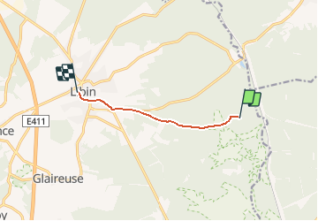
Tocht Stappen van 4,9 km beschikbaar op Wallonië, Luxemburg, Libin. Deze tocht wordt voorgesteld door La Grande Forêt de Saint-Hubert.
Beschrijving
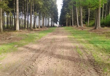
Ce parcours permet de relier le parcours "Entre Lesse et Lomme", du point 18-L-"Aux Tachenires", au village de Libin.
Plaatsbepaling
Land:
Belgium
Regio :
Wallonië
Departement/Provincie :
Luxemburg
Gemeente :
Libin
Locatie:
Libin
Vertrek:(Dec)
Vertrek:(UTM)
666211 ; 5538337 (31U) N.
Opmerkingen
Wandeltochten in de omgeving
![Tocht Stappen Saint-Hubert - Hatrival - Banalbois (SH13) - Photo](https://media.geolcdn.com/t/375/260/ext.jpg?maxdim=2&url=https%3A%2F%2Fservices.sitytrail.com%2FGeolivesWS%2FDownloadMedia.ashx%3FTrailID%3D334467%26Media%3D16828998-416a-43a0-960f-95ce479e5d6d.jpg)
![Stappen Stappen](https://static1.geolcdn.com/sitytour/trail-icons/101.png)
Hatrival - Banalbois (SH13)
Stappen
Medium
(6)
Saint-Hubert,
Wallonië,
Luxemburg,
Belgium
![](/images/other/stat-length.png)
7,5 km | 9,5 km-effort
2h 2min
![](https://static1.geolcdn.com/siteimages/upload/files/16400158638029165_repeat_loop_refresh_sync_direction_icon.png)
Ja
![Tocht Mountainbike Saint-Hubert - Poix - La Lhomme (VTT SH06) - Photo](https://media.geolcdn.com/t/375/260/ext.jpg?maxdim=2&url=https%3A%2F%2Fservices.sitytrail.com%2FGeolivesWS%2FDownloadMedia.ashx%3FTrailID%3D334556%26Media%3Da91ea124-054e-449d-9773-8d26e176c2fd.jpg)
![Mountainbike Mountainbike](https://static1.geolcdn.com/sitytour/trail-icons/202.png)
Poix - La Lhomme (VTT SH06)
Mountainbike
Medium
(4)
Saint-Hubert,
Wallonië,
Luxemburg,
Belgium
![](/images/other/stat-length.png)
24 km | 31 km-effort
2h 1min
![](https://static1.geolcdn.com/siteimages/upload/files/16400158638029165_repeat_loop_refresh_sync_direction_icon.png)
Ja
![Tocht Stappen Libin - Libin par dessus - Photo](https://media.geolcdn.com/t/375/260/abf79579-5895-454e-ada2-cb9d595cfe0c.jpg&format=jpg&maxdim=2)
![Stappen Stappen](https://static1.geolcdn.com/sitytour/trail-icons/101.png)
Libin par dessus
Stappen
Gemakkelijk
(3)
Libin,
Wallonië,
Luxemburg,
Belgium
![](/images/other/stat-length.png)
8,2 km | 10 km-effort
1h 45min
![](https://static1.geolcdn.com/siteimages/upload/files/16400158638029165_repeat_loop_refresh_sync_direction_icon.png)
Ja
![Tocht Stappen Libin - Smuid - Promenade du bois de Renimont - Photo](https://media.geolcdn.com/t/375/260/797a85ad-6b8a-4d5d-804f-0c47f97e93d7.jpg&format=jpg&maxdim=2)
![Stappen Stappen](https://static1.geolcdn.com/sitytour/trail-icons/101.png)
Smuid - Promenade du bois de Renimont
Stappen
Gemakkelijk
(1)
Libin,
Wallonië,
Luxemburg,
Belgium
![](/images/other/stat-length.png)
10,2 km | 13,4 km-effort
2h 56min
![](https://static1.geolcdn.com/siteimages/upload/files/16400158638029165_repeat_loop_refresh_sync_direction_icon.png)
Ja
![Tocht Stappen Libin - Smuid - Promenade de Smuid - Photo](https://media.geolcdn.com/t/375/260/4927d3fd-64d5-402b-b051-09b0154a8357.jpg&format=jpg&maxdim=2)
![Stappen Stappen](https://static1.geolcdn.com/sitytour/trail-icons/101.png)
Smuid - Promenade de Smuid
Stappen
Medium
(3)
Libin,
Wallonië,
Luxemburg,
Belgium
![](/images/other/stat-length.png)
4,9 km | 6,4 km-effort
1h 27min
![](https://static1.geolcdn.com/siteimages/upload/files/16400158638029165_repeat_loop_refresh_sync_direction_icon.png)
Ja
![Tocht Stappen Libin - Ochamps - Promenade des Troufferies - Photo](https://media.geolcdn.com/t/375/260/ext.jpg?maxdim=2&url=https%3A%2F%2Fservices.sitytrail.com%2FGeolivesWS%2FDownloadMedia.ashx%3FTrailID%3D334592%26Media%3Dea0a02bc-49fa-4aa1-95ad-2cae7226436b.jpeg)
![Stappen Stappen](https://static1.geolcdn.com/sitytour/trail-icons/101.png)
Ochamps - Promenade des Troufferies
Stappen
Medium
(10)
Libin,
Wallonië,
Luxemburg,
Belgium
![](/images/other/stat-length.png)
5,8 km | 7,4 km-effort
1h 35min
![](https://static1.geolcdn.com/siteimages/upload/files/16400158638029165_repeat_loop_refresh_sync_direction_icon.png)
Ja
![Tocht Stappen Saint-Hubert - Hatrival - Hatrival (SH11) - Photo](https://media.geolcdn.com/t/375/260/ext.jpg?maxdim=2&url=https%3A%2F%2Fservices.sitytrail.com%2FGeolivesWS%2FDownloadMedia.ashx%3FTrailID%3D334445%26Media%3D0f06cf58-f0eb-4df9-9750-5fbe487dabd3.jpg)
![Stappen Stappen](https://static1.geolcdn.com/sitytour/trail-icons/101.png)
Hatrival - Hatrival (SH11)
Stappen
Medium
(3)
Saint-Hubert,
Wallonië,
Luxemburg,
Belgium
![](/images/other/stat-length.png)
7,4 km | 9,3 km-effort
1h 59min
![](https://static1.geolcdn.com/siteimages/upload/files/16400158638029165_repeat_loop_refresh_sync_direction_icon.png)
Ja
![Tocht Stappen Libin - Libin - Le chemin du Kaolin (LI20) - Photo](https://media.geolcdn.com/t/375/260/81ded542-51a5-43ef-9a5e-462bfce08e3b.jpg&format=jpg&maxdim=2)
![Stappen Stappen](https://static1.geolcdn.com/sitytour/trail-icons/101.png)
Libin - Le chemin du Kaolin (LI20)
Stappen
Heel gemakkelijk
(3)
Libin,
Wallonië,
Luxemburg,
Belgium
![](/images/other/stat-length.png)
3,4 km | 4,3 km-effort
1h 4min
![](https://static1.geolcdn.com/siteimages/upload/files/16400158638029165_repeat_loop_refresh_sync_direction_icon.png)
Ja
![Tocht Stappen Libin - Marche ADEPS 100km600 à Libin - Photo](https://media.geolcdn.com/t/375/260/39863a41-1a3a-4d5a-8714-29a30f1fe819.jpg&format=jpg&maxdim=2)
![Stappen Stappen](https://static1.geolcdn.com/sitytour/trail-icons/101.png)
Marche ADEPS 100km600 à Libin
Stappen
Gemakkelijk
Libin,
Wallonië,
Luxemburg,
Belgium
![](/images/other/stat-length.png)
10,6 km | 13 km-effort
2h 7min
![](https://static1.geolcdn.com/siteimages/upload/files/16400158638029165_repeat_loop_refresh_sync_direction_icon.png)
Ja