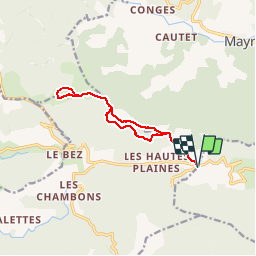
![](/images/other/stat-length.png)
![Tocht Sneeuwschoenen Mayres - Col des Pergeyres -Massif du Tanargue - Photo](https://media.geolcdn.com/t/1900/400/ext.pjpeg?maxdim=2&url=https%3A%2F%2Fstatic1.geolcdn.com%2Fsiteimages%2Fupload%2Ffiles%2F1524743153raquette.jpg)
Col des Pergeyres -Massif du Tanargue
will83
Gebruiker
![Lengte](/images/other/stat-length.png)
![Max. hoogte](https://static1.geolcdn.com/siteimages/upload/files/1508320355ic_sort_altitude_max_24dp.png)
![Positief hoogteverschil](https://static1.geolcdn.com/siteimages/upload/files/1508320355ic_sort_den_pos_24dp.png)
![Km-Effort](/images/other/stat-length.png)
![Min. hoogte](https://static1.geolcdn.com/siteimages/upload/files/1508320355ic_sort_altitude_min_24dp.png)
![Negatief hoogteverschil](https://static1.geolcdn.com/siteimages/upload/files/1508320355ic_sort_den_neg_24dp.png)
![Boucle](https://static1.geolcdn.com/siteimages/upload/files/16400158638029165_repeat_loop_refresh_sync_direction_icon.png)
![Sneeuwschoenen](https://static1.geolcdn.com/sitytour/trail-icons/504.png)
4h00
Moeilijkheid : Gemakkelijk
![Scan deze QR-code om de tocht te openen in de SityTrail-applicatie](https://capi.geolives.com/qq0zvz2zws4bq2lad0pu/sitytour/trails/712791/qr.png?size=200)
Gratisgps-wandelapplicatie
Over ons
Tocht Sneeuwschoenen van 11 km beschikbaar op Auvergne-Rhône-Alpes, Ardèche, Mayres. Deze tocht wordt voorgesteld door will83.
Beschrijving
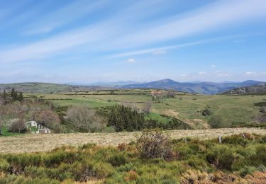
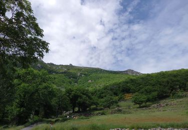
Au départ de la station de la la croix de Bauzon, belle balade en raquette alternant crête et forêt. Du col, splendide vue d'un côté sur le Massif Central avec le Mont Lozère et de l'autre côté, vue sur les Alpes et le massif des Ecrins. Circuit ensoleillé sur les versants sud (La neige peut manquer au début de l'itinéraire selon la saison)
Plaatsbepaling
Opmerkingen
Wandeltochten in de omgeving
![Tocht Stappen Mayres - 07 rocher d abraham - Photo](https://media.geolcdn.com/t/375/260/ext.jpg?maxdim=2&url=https%3A%2F%2Fstatic1.geolcdn.com%2Fsiteimages%2Fupload%2Ffiles%2F1553511878bg_sport_marche.png)
![Stappen Stappen](https://static1.geolcdn.com/sitytour/trail-icons/101.png)
Stappen
![](/images/other/stat-length.png)
![](https://static1.geolcdn.com/siteimages/upload/files/16400158638029165_repeat_loop_refresh_sync_direction_icon.png)
![Tocht Stappen Borne - croix de beauzon - Photo](https://media.geolcdn.com/t/375/260/217677dd-c155-48af-bc87-419b5b32c8ce.jpg&format=jpg&maxdim=2)
![Stappen Stappen](https://static1.geolcdn.com/sitytour/trail-icons/101.png)
Stappen
![](/images/other/stat-length.png)
![](https://static1.geolcdn.com/siteimages/upload/files/16400158638029165_repeat_loop_refresh_sync_direction_icon.png)
![Tocht Stappen Mayres - Mayres Chaumiène 12km - Photo](https://media.geolcdn.com/t/375/260/a133b020-a8a4-4863-bdb6-488ddda17997.jpg&format=jpg&maxdim=2)
![Stappen Stappen](https://static1.geolcdn.com/sitytour/trail-icons/101.png)
Stappen
![](/images/other/stat-length.png)
![](https://static1.geolcdn.com/siteimages/upload/files/16400158638029165_repeat_loop_refresh_sync_direction_icon.png)
![Tocht Stappen Valgorge - Le Tanargue - Photo](https://media.geolcdn.com/t/375/260/ad0e721e-bf17-4b50-b28e-4b195a037c98.jpg&format=jpg&maxdim=2)
![Stappen Stappen](https://static1.geolcdn.com/sitytour/trail-icons/101.png)
Stappen
![](/images/other/stat-length.png)
![](https://static1.geolcdn.com/siteimages/upload/files/16400158638029165_repeat_loop_refresh_sync_direction_icon.png)
![Tocht Stappen Loubaresse - Loubaresse ruisseau de goutelles 10 km - Photo](https://media.geolcdn.com/t/375/260/7fb7aff1-6923-41f8-900d-5aa3bb3bfe91.jpg&format=jpg&maxdim=2)
![Stappen Stappen](https://static1.geolcdn.com/sitytour/trail-icons/101.png)
Stappen
![](/images/other/stat-length.png)
![](https://static1.geolcdn.com/siteimages/upload/files/16400158638029165_repeat_loop_refresh_sync_direction_icon.png)
![Tocht Stappen Loubaresse - Loubaresse Nord 5,2 km - Photo](https://media.geolcdn.com/t/375/260/5ae50d28-b170-4d44-aab5-94560c77c18b.jpg&format=jpg&maxdim=2)
![Stappen Stappen](https://static1.geolcdn.com/sitytour/trail-icons/101.png)
Stappen
![](/images/other/stat-length.png)
![](https://static1.geolcdn.com/siteimages/upload/files/16400158638029165_repeat_loop_refresh_sync_direction_icon.png)
![Tocht Stappen Borne - 2023-01-26_14h31m24_Station Croix de Bauzon 14 km.gpx.xml - Photo](https://media.geolcdn.com/t/375/260/186f655e-2b32-453c-b04b-facbcec1469b.jpg&format=jpg&maxdim=2)
![Stappen Stappen](https://static1.geolcdn.com/sitytour/trail-icons/101.png)
Stappen
![](/images/other/stat-length.png)
![](https://static1.geolcdn.com/siteimages/upload/files/16400158638029165_repeat_loop_refresh_sync_direction_icon.png)
![Tocht Te voet Mayres - Tour des Poignets 18km - Photo](https://media.geolcdn.com/t/375/260/4695ff56-51f7-439d-a787-0d719ef81c46.jpg&format=jpg&maxdim=2)
![Te voet Te voet](https://static1.geolcdn.com/sitytour/trail-icons/100.png)
Te voet
![](/images/other/stat-length.png)
![](https://static1.geolcdn.com/siteimages/upload/files/16400158638029165_repeat_loop_refresh_sync_direction_icon.png)
![Tocht Stappen Saint-Étienne-de-Lugdarès - Le Bez-Borne-les Chambons - Photo](https://media.geolcdn.com/t/375/260/84516e8e-4390-46d3-bf0d-44f54607fcbb.jpg&format=jpg&maxdim=2)
![Stappen Stappen](https://static1.geolcdn.com/sitytour/trail-icons/101.png)
Stappen
![](/images/other/stat-length.png)
![](https://static1.geolcdn.com/siteimages/upload/files/16400158638029165_repeat_loop_refresh_sync_direction_icon.png)