![](/images/other/stat-length.png)
![Tocht Stappen Dombasle-sur-Meurthe - Dombasle Lunéville - Photo](https://media.geolcdn.com/t/1900/400/ext.pjpeg?maxdim=2&url=https%3A%2F%2Fstatic1.geolcdn.com%2Fsiteimages%2Fupload%2Ffiles%2F1553511878bg_sport_marche.png)
Dombasle Lunéville
joelclaudel
Gebruiker
![Lengte](/images/other/stat-length.png)
Lengte
21 km
![Max. hoogte](https://static1.geolcdn.com/siteimages/upload/files/1508320355ic_sort_altitude_max_24dp.png)
Max. hoogte
324 m
![Positief hoogteverschil](https://static1.geolcdn.com/siteimages/upload/files/1508320355ic_sort_den_pos_24dp.png)
Positief hoogteverschil
266 m
![Km-Effort](/images/other/stat-length.png)
Km-Effort
24 km
![Min. hoogte](https://static1.geolcdn.com/siteimages/upload/files/1508320355ic_sort_altitude_min_24dp.png)
Min. hoogte
203 m
![Negatief hoogteverschil](https://static1.geolcdn.com/siteimages/upload/files/1508320355ic_sort_den_neg_24dp.png)
Negatief hoogteverschil
244 m
![Boucle](https://static1.geolcdn.com/siteimages/upload/files/16400158638029165_repeat_loop_refresh_sync_direction_icon.png)
Boucle
Neen
Datum van aanmaak :
2017-02-14 00:00:00.0
Laatste wijziging :
2017-02-14 00:00:00.0
![Stappen](https://static1.geolcdn.com/sitytour/trail-icons/101.png)
4h10
Moeilijkheid : Medium
![Scan deze QR-code om de tocht te openen in de SityTrail-applicatie](https://capi.geolives.com/qq0zvz2zws4bq2lad0pu/sitytour/trails/698400/qr.png?size=200)
Gratisgps-wandelapplicatie
Over ons
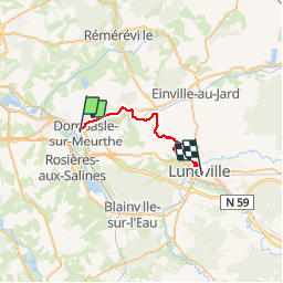
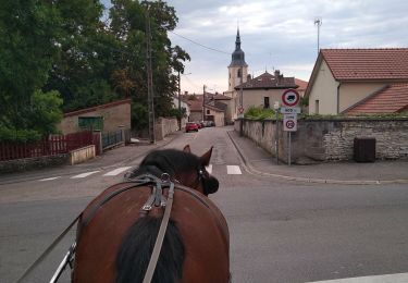
Tocht Stappen van 21 km beschikbaar op Grand Est, Meurthe-et-Moselle, Dombasle-sur-Meurthe. Deze tocht wordt voorgesteld door joelclaudel.
Beschrijving
Par canal jusqu'à Crévic, puis GR 534 jusqu'à Lunéville.
Parcours Nancy Dombasle et Lunéville Nancy par le train
Plaatsbepaling
Land:
France
Regio :
Grand Est
Departement/Provincie :
Meurthe-et-Moselle
Gemeente :
Dombasle-sur-Meurthe
Locatie:
Unknown
Vertrek:(Dec)
Vertrek:(UTM)
304256 ; 5389002 (32U) N.
Opmerkingen
Wandeltochten in de omgeving
![Tocht Te voet Crévic - Circuit de Naveau - Photo](https://media.geolcdn.com/t/375/260/691858f4-7c47-42aa-8d70-1d0de8256d12.jpeg&format=jpg&maxdim=2)
![Te voet Te voet](https://static1.geolcdn.com/sitytour/trail-icons/100.png)
Circuit de Naveau
Te voet
Gemakkelijk
Crévic,
Grand Est,
Meurthe-et-Moselle,
France
![](/images/other/stat-length.png)
7,7 km | 8,6 km-effort
1h 56min
![](https://static1.geolcdn.com/siteimages/upload/files/16400158638029165_repeat_loop_refresh_sync_direction_icon.png)
Ja
![Tocht Elektrische fiets Rosières-aux-Salines - sortie vtt 21022023 rosière aux salines - Photo](https://media.geolcdn.com/t/375/260/82282d0a-95fb-4516-8676-7a778abc020b.jpg&format=jpg&maxdim=2)
![Elektrische fiets Elektrische fiets](https://static1.geolcdn.com/sitytour/trail-icons/205.png)
sortie vtt 21022023 rosière aux salines
Elektrische fiets
Moeilijk
Rosières-aux-Salines,
Grand Est,
Meurthe-et-Moselle,
France
![](/images/other/stat-length.png)
46 km | 53 km-effort
2h 6min
![](https://static1.geolcdn.com/siteimages/upload/files/16400158638029165_repeat_loop_refresh_sync_direction_icon.png)
Ja
![Tocht Stappen Rosières-aux-Salines - rosières aux salines - Photo](https://media.geolcdn.com/t/375/260/2e6c7cdb-e8b3-4feb-b4f1-e4383a03310c.jpg&format=jpg&maxdim=2)
![Stappen Stappen](https://static1.geolcdn.com/sitytour/trail-icons/101.png)
rosières aux salines
Stappen
Medium
Rosières-aux-Salines,
Grand Est,
Meurthe-et-Moselle,
France
![](/images/other/stat-length.png)
14,3 km | 16,6 km-effort
3h 9min
![](https://static1.geolcdn.com/siteimages/upload/files/16400158638029165_repeat_loop_refresh_sync_direction_icon.png)
Ja
![Tocht Huifkarwandeling Rosières-aux-Salines - Rosieres, route des vergers, tour de Nancy - Photo](https://media.geolcdn.com/t/375/260/96d85ed2-abd4-4bd3-8710-b6e3041688f6.jpg&format=jpg&maxdim=2)
![Huifkarwandeling Huifkarwandeling](https://static1.geolcdn.com/sitytour/trail-icons/302.png)
Rosieres, route des vergers, tour de Nancy
Huifkarwandeling
Medium
Rosières-aux-Salines,
Grand Est,
Meurthe-et-Moselle,
France
![](/images/other/stat-length.png)
9,8 km | 11,7 km-effort
1h 43min
![](https://static1.geolcdn.com/siteimages/upload/files/16400158638029165_repeat_loop_refresh_sync_direction_icon.png)
Neen
![Stappen Stappen](https://static1.geolcdn.com/sitytour/trail-icons/101.png)
essai_4km
Stappen
Gemakkelijk
Dombasle-sur-Meurthe,
Grand Est,
Meurthe-et-Moselle,
France
![](/images/other/stat-length.png)
4,5 km | 4,9 km-effort
1h 6min
![](https://static1.geolcdn.com/siteimages/upload/files/16400158638029165_repeat_loop_refresh_sync_direction_icon.png)
Ja
![Tocht Mountainbike Varangéville - randonnée vtt varangeville 20092015 - Photo](https://media.geolcdn.com/t/375/260/ext.jpg?maxdim=2&url=https%3A%2F%2Fstatic1.geolcdn.com%2Fsiteimages%2Fupload%2Ffiles%2F1524743154velo.jpg)
![Mountainbike Mountainbike](https://static1.geolcdn.com/sitytour/trail-icons/202.png)
randonnée vtt varangeville 20092015
Mountainbike
Moeilijk
Varangéville,
Grand Est,
Meurthe-et-Moselle,
France
![](/images/other/stat-length.png)
25 km | 31 km-effort
2h 1min
![](https://static1.geolcdn.com/siteimages/upload/files/16400158638029165_repeat_loop_refresh_sync_direction_icon.png)
Ja
![Tocht Stappen Crévic - Crévic 08 novembre 24 - Photo](https://media.geolcdn.com/t/375/260/ext.jpg?maxdim=2&url=https%3A%2F%2Fstatic1.geolcdn.com%2Fsiteimages%2Fupload%2Ffiles%2F1553511878bg_sport_marche.png)
![Stappen Stappen](https://static1.geolcdn.com/sitytour/trail-icons/101.png)
Crévic 08 novembre 24
Stappen
Medium
Crévic,
Grand Est,
Meurthe-et-Moselle,
France
![](/images/other/stat-length.png)
9,9 km | 10,9 km-effort
2h 10min
![](https://static1.geolcdn.com/siteimages/upload/files/16400158638029165_repeat_loop_refresh_sync_direction_icon.png)
Ja
![Tocht Noords wandelen Dombasle-sur-Meurthe - MN initiation du 07102024 - Photo](https://media.geolcdn.com/t/375/260/ext.jpg?maxdim=2&url=https%3A%2F%2Fstatic1.geolcdn.com%2Fsiteimages%2Fupload%2Ffiles%2F1545311037marcheuse_200dpi.jpg)
![Noords wandelen Noords wandelen](https://static1.geolcdn.com/sitytour/trail-icons/102.png)
MN initiation du 07102024
Noords wandelen
Heel gemakkelijk
Dombasle-sur-Meurthe,
Grand Est,
Meurthe-et-Moselle,
France
![](/images/other/stat-length.png)
4,7 km | 5,5 km-effort
Onbekend
![](https://static1.geolcdn.com/siteimages/upload/files/16400158638029165_repeat_loop_refresh_sync_direction_icon.png)
Ja
![Tocht Noords wandelen Rosières-aux-Salines - rosieres MN du 29 aout 2024 - Photo](https://media.geolcdn.com/t/375/260/ext.jpg?maxdim=2&url=https%3A%2F%2Fstatic1.geolcdn.com%2Fsiteimages%2Fupload%2Ffiles%2F1545311037marcheuse_200dpi.jpg)
![Noords wandelen Noords wandelen](https://static1.geolcdn.com/sitytour/trail-icons/102.png)
rosieres MN du 29 aout 2024
Noords wandelen
Heel gemakkelijk
Rosières-aux-Salines,
Grand Est,
Meurthe-et-Moselle,
France
![](/images/other/stat-length.png)
6 km | 7,4 km-effort
Onbekend
![](https://static1.geolcdn.com/siteimages/upload/files/16400158638029165_repeat_loop_refresh_sync_direction_icon.png)
Ja