![](/images/other/stat-length.png)
![Tocht Stappen Champagne-Vigny - Maine Giraud, Champagne-Vigny - Photo](https://media.geolcdn.com/t/1900/400/ext.pjpeg?maxdim=2&url=https%3A%2F%2Fstatic1.geolcdn.com%2Fsiteimages%2Fupload%2Ffiles%2F1553511878bg_sport_marche.png)
Maine Giraud, Champagne-Vigny
dorcier
Gebruiker
![Lengte](/images/other/stat-length.png)
Lengte
12,2 km
![Max. hoogte](https://static1.geolcdn.com/siteimages/upload/files/1508320355ic_sort_altitude_max_24dp.png)
Max. hoogte
148 m
![Positief hoogteverschil](https://static1.geolcdn.com/siteimages/upload/files/1508320355ic_sort_den_pos_24dp.png)
Positief hoogteverschil
198 m
![Km-Effort](/images/other/stat-length.png)
Km-Effort
14,8 km
![Min. hoogte](https://static1.geolcdn.com/siteimages/upload/files/1508320355ic_sort_altitude_min_24dp.png)
Min. hoogte
71 m
![Negatief hoogteverschil](https://static1.geolcdn.com/siteimages/upload/files/1508320355ic_sort_den_neg_24dp.png)
Negatief hoogteverschil
198 m
![Boucle](https://static1.geolcdn.com/siteimages/upload/files/16400158638029165_repeat_loop_refresh_sync_direction_icon.png)
Boucle
Ja
Datum van aanmaak :
2017-03-27 00:00:00.0
Laatste wijziging :
2017-03-27 00:00:00.0
![Stappen](https://static1.geolcdn.com/sitytour/trail-icons/101.png)
3h13
Moeilijkheid : Gemakkelijk
![Scan deze QR-code om de tocht te openen in de SityTrail-applicatie](https://capi.geolives.com/qq0zvz2zws4bq2lad0pu/sitytour/trails/696388/qr.png?size=200)
Gratisgps-wandelapplicatie
Over ons
Tocht Stappen van 12,2 km beschikbaar op Nieuw-Aquitanië, Charente, Champagne-Vigny. Deze tocht wordt voorgesteld door dorcier.
Beschrijving
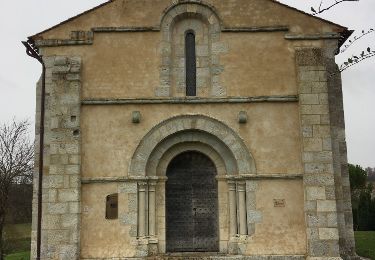
au départ du manoir du maine Giraud, propriété d'Alfred de Vigny où il écrivit en particulier le célèbre poême "L mort du loup"
Plaatsbepaling
Land:
France
Regio :
Nieuw-Aquitanië
Departement/Provincie :
Charente
Gemeente :
Champagne-Vigny
Locatie:
Unknown
Vertrek:(Dec)
Vertrek:(UTM)
267884 ; 5042410 (31T) N.
Opmerkingen
Wandeltochten in de omgeving
![Tocht Stappen Plassac-Rouffiac - PlassacRouffiac - Photo](https://media.geolcdn.com/t/375/260/f5b667ec-5cc6-4110-86c4-a08ca7afdd2f.jpg&format=jpg&maxdim=2)
![Stappen Stappen](https://static1.geolcdn.com/sitytour/trail-icons/101.png)
PlassacRouffiac
Stappen
Medium
Plassac-Rouffiac,
Nieuw-Aquitanië,
Charente,
France
![](/images/other/stat-length.png)
8,5 km | 10,5 km-effort
2h 22min
![](https://static1.geolcdn.com/siteimages/upload/files/16400158638029165_repeat_loop_refresh_sync_direction_icon.png)
Ja
![Tocht Stappen Val-des-Vignes - Pereuil - Photo](https://media.geolcdn.com/t/375/260/ext.jpg?maxdim=2&url=https%3A%2F%2Fservices.sitytrail.com%2FGeolivesWS%2FDownloadMedia.ashx%3FTrailID%3D715727%26Media%3D20170309161132.jpg)
![Stappen Stappen](https://static1.geolcdn.com/sitytour/trail-icons/101.png)
Pereuil
Stappen
Gemakkelijk
Val-des-Vignes,
Nieuw-Aquitanië,
Charente,
France
![](/images/other/stat-length.png)
9,9 km | 12 km-effort
2h 37min
![](https://static1.geolcdn.com/siteimages/upload/files/16400158638029165_repeat_loop_refresh_sync_direction_icon.png)
Ja
![Tocht sport Champagne-Vigny - Chez Normandin - Photo](https://media.geolcdn.com/t/375/260/ext.jpg?maxdim=2&url=https%3A%2F%2Fsecurestorage.geolives.com%2Fsitytour%2Ftrail-bg%2Fdefault.jpg)
Chez Normandin
sport
Heel gemakkelijk
Champagne-Vigny,
Nieuw-Aquitanië,
Charente,
France
![](/images/other/stat-length.png)
8,4 km | 10,4 km-effort
Onbekend
![](https://static1.geolcdn.com/siteimages/upload/files/16400158638029165_repeat_loop_refresh_sync_direction_icon.png)
Ja
![Tocht Stappen Pérignac - Pérignac 260422 - Photo](https://media.geolcdn.com/t/375/260/ext.jpg?maxdim=2&url=https%3A%2F%2Fstatic1.geolcdn.com%2Fsiteimages%2Fupload%2Ffiles%2F1553511878bg_sport_marche.png)
![Stappen Stappen](https://static1.geolcdn.com/sitytour/trail-icons/101.png)
Pérignac 260422
Stappen
Moeilijk
Pérignac,
Nieuw-Aquitanië,
Charente,
France
![](/images/other/stat-length.png)
10,9 km | 14,3 km-effort
2h 29min
![](https://static1.geolcdn.com/siteimages/upload/files/16400158638029165_repeat_loop_refresh_sync_direction_icon.png)
Ja
![Tocht Stappen Étriac - Etriac - Photo](https://media.geolcdn.com/t/375/260/ext.jpg?maxdim=2&url=https%3A%2F%2Fstatic1.geolcdn.com%2Fsiteimages%2Fupload%2Ffiles%2F1553511878bg_sport_marche.png)
![Stappen Stappen](https://static1.geolcdn.com/sitytour/trail-icons/101.png)
![Tocht Stappen Coteaux-du-Blanzacais - saint léger de blanzac - Photo](https://media.geolcdn.com/t/375/260/ext.jpg?maxdim=2&url=https%3A%2F%2Fservices.sitytrail.com%2FGeolivesWS%2FDownloadMedia.ashx%3FTrailID%3D1088302%26Media%3D20181213150108.jpg)
![Stappen Stappen](https://static1.geolcdn.com/sitytour/trail-icons/101.png)
saint léger de blanzac
Stappen
Heel gemakkelijk
Coteaux-du-Blanzacais,
Nieuw-Aquitanië,
Charente,
France
![](/images/other/stat-length.png)
7,5 km | 9,1 km-effort
1h 52min
![](https://static1.geolcdn.com/siteimages/upload/files/16400158638029165_repeat_loop_refresh_sync_direction_icon.png)
Ja
![Tocht Stappen Pérignac - Perignac - Photo](https://media.geolcdn.com/t/375/260/ext.jpg?maxdim=2&url=https%3A%2F%2Fstatic1.geolcdn.com%2Fsiteimages%2Fupload%2Ffiles%2F1553511878bg_sport_marche.png)
![Stappen Stappen](https://static1.geolcdn.com/sitytour/trail-icons/101.png)
Perignac
Stappen
Gemakkelijk
Pérignac,
Nieuw-Aquitanië,
Charente,
France
![](/images/other/stat-length.png)
14,1 km | 17,8 km-effort
3h 26min
![](https://static1.geolcdn.com/siteimages/upload/files/16400158638029165_repeat_loop_refresh_sync_direction_icon.png)
Ja
![Tocht Stappen Val-des-Vignes - chemin des moulins-Pereuil - 31-08-2014 - Photo](https://media.geolcdn.com/t/375/260/ext.jpg?maxdim=2&url=https%3A%2F%2Fstatic1.geolcdn.com%2Fsiteimages%2Fupload%2Ffiles%2F1553511878bg_sport_marche.png)
![Stappen Stappen](https://static1.geolcdn.com/sitytour/trail-icons/101.png)
chemin des moulins-Pereuil - 31-08-2014
Stappen
Medium
Val-des-Vignes,
Nieuw-Aquitanië,
Charente,
France
![](/images/other/stat-length.png)
17,3 km | 21 km-effort
3h 48min
![](https://static1.geolcdn.com/siteimages/upload/files/16400158638029165_repeat_loop_refresh_sync_direction_icon.png)
Ja
![Tocht Stappen Val-des-Vignes - Blanzac-Pereuil - Photo](https://media.geolcdn.com/t/375/260/ext.jpg?maxdim=2&url=https%3A%2F%2Fstatic1.geolcdn.com%2Fsiteimages%2Fupload%2Ffiles%2F1553511878bg_sport_marche.png)
![Stappen Stappen](https://static1.geolcdn.com/sitytour/trail-icons/101.png)
Blanzac-Pereuil
Stappen
Gemakkelijk
Val-des-Vignes,
Nieuw-Aquitanië,
Charente,
France
![](/images/other/stat-length.png)
12,1 km | 14,4 km-effort
2h 33min
![](https://static1.geolcdn.com/siteimages/upload/files/16400158638029165_repeat_loop_refresh_sync_direction_icon.png)
Ja