![](/images/other/stat-length.png)
![Tocht Andere activiteiten Argences - Basse Normandie - Ligne 00I - Moult - Argences - Photo](https://media.geolcdn.com/t/1900/400/ext.pjpeg?maxdim=2&url=https%3A%2F%2Fstatic1.geolcdn.com%2Fsiteimages%2Fupload%2Ffiles%2F1545311037marcheuse_200dpi.jpg)
Basse Normandie - Ligne 00I - Moult - Argences
mich54
Gebruiker
![Lengte](/images/other/stat-length.png)
Lengte
1,8 km
![Max. hoogte](https://static1.geolcdn.com/siteimages/upload/files/1508320355ic_sort_altitude_max_24dp.png)
Max. hoogte
37 m
![Positief hoogteverschil](https://static1.geolcdn.com/siteimages/upload/files/1508320355ic_sort_den_pos_24dp.png)
Positief hoogteverschil
15 m
![Km-Effort](/images/other/stat-length.png)
Km-Effort
2 km
![Min. hoogte](https://static1.geolcdn.com/siteimages/upload/files/1508320355ic_sort_altitude_min_24dp.png)
Min. hoogte
23 m
![Negatief hoogteverschil](https://static1.geolcdn.com/siteimages/upload/files/1508320355ic_sort_den_neg_24dp.png)
Negatief hoogteverschil
3 m
![Boucle](https://static1.geolcdn.com/siteimages/upload/files/16400158638029165_repeat_loop_refresh_sync_direction_icon.png)
Boucle
Neen
Datum van aanmaak :
2017-01-23 00:00:00.0
Laatste wijziging :
2017-01-23 00:00:00.0
![Andere activiteiten](https://static1.geolcdn.com/sitytour/trail-icons/900.png)
5m
Moeilijkheid : Onbekend
![Scan deze QR-code om de tocht te openen in de SityTrail-applicatie](https://capi.geolives.com/qq0zvz2zws4bq2lad0pu/sitytour/trails/686557/qr.png?size=200)
Gratisgps-wandelapplicatie
Over ons
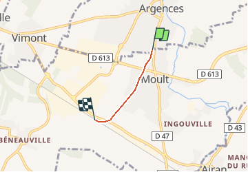
Tocht Andere activiteiten van 1,8 km beschikbaar op Normandië, Calvados, Argences. Deze tocht wordt voorgesteld door mich54.
Beschrijving
La gare de Moult - Argences est une halte ferroviaire française située sur la commune de Moult à proximité d'Argences dans le département du Calvados en région Basse-Normandie.(Source Wikipédia)
Plaatsbepaling
Land:
France
Regio :
Normandië
Departement/Provincie :
Calvados
Gemeente :
Argences
Locatie:
Unknown
Vertrek:(Dec)
Vertrek:(UTM)
706743 ; 5444691 (30U) N.
Opmerkingen
Wandeltochten in de omgeving
![Tocht Stappen Saint-Ouen-du-Mesnil-Oger - st ouen du mesnil oger - Photo](https://media.geolcdn.com/t/375/260/ext.jpg?maxdim=2&url=https%3A%2F%2Fservices.sitytrail.com%2FGeolivesWS%2FDownloadMedia.ashx%3FTrailID%3D315322%26Media%3Dfix__20140622162003.jpg)
![Stappen Stappen](https://static1.geolcdn.com/sitytour/trail-icons/101.png)
st ouen du mesnil oger
Stappen
Heel gemakkelijk
(1)
Saint-Ouen-du-Mesnil-Oger,
Normandië,
Calvados,
France
![](/images/other/stat-length.png)
5,1 km | 5,5 km-effort
1h 20min
![](https://static1.geolcdn.com/siteimages/upload/files/16400158638029165_repeat_loop_refresh_sync_direction_icon.png)
Neen
![Tocht Noords wandelen Moult-Chicheboville - 41b_les_eoliennes-6844076-1676016099-46 - Photo](https://media.geolcdn.com/t/375/260/ext.jpg?maxdim=2&url=https%3A%2F%2Fstatic1.geolcdn.com%2Fsiteimages%2Fupload%2Ffiles%2F1545311037marcheuse_200dpi.jpg)
![Noords wandelen Noords wandelen](https://static1.geolcdn.com/sitytour/trail-icons/102.png)
41b_les_eoliennes-6844076-1676016099-46
Noords wandelen
Heel gemakkelijk
(1)
Moult-Chicheboville,
Normandië,
Calvados,
France
![](/images/other/stat-length.png)
8,6 km | 9,4 km-effort
Onbekend
![](https://static1.geolcdn.com/siteimages/upload/files/16400158638029165_repeat_loop_refresh_sync_direction_icon.png)
Ja
![Tocht Noords wandelen Moult-Chicheboville - 2b_moult_bois_saint_gilles-11832667-1675352732-615 - Photo](https://media.geolcdn.com/t/375/260/ext.jpg?maxdim=2&url=https%3A%2F%2Fstatic1.geolcdn.com%2Fsiteimages%2Fupload%2Ffiles%2F1545311037marcheuse_200dpi.jpg)
![Noords wandelen Noords wandelen](https://static1.geolcdn.com/sitytour/trail-icons/102.png)
2b_moult_bois_saint_gilles-11832667-1675352732-615
Noords wandelen
Heel gemakkelijk
(1)
Moult-Chicheboville,
Normandië,
Calvados,
France
![](/images/other/stat-length.png)
8,7 km | 10 km-effort
Onbekend
![](https://static1.geolcdn.com/siteimages/upload/files/16400158638029165_repeat_loop_refresh_sync_direction_icon.png)
Ja
![Tocht Te voet Argences - Les Crêtes d'Argences - Photo](https://media.geolcdn.com/t/375/260/8b099ab6-801d-4680-9ab3-17437fd28505.jpeg&format=jpg&maxdim=2)
![Te voet Te voet](https://static1.geolcdn.com/sitytour/trail-icons/100.png)
Les Crêtes d'Argences
Te voet
Gemakkelijk
Argences,
Normandië,
Calvados,
France
![](/images/other/stat-length.png)
6 km | 7,1 km-effort
1h 37min
![](https://static1.geolcdn.com/siteimages/upload/files/16400158638029165_repeat_loop_refresh_sync_direction_icon.png)
Ja
![Tocht Te voet Argences - Les Sentes de l'Avant Côte d'Auge - Photo](https://media.geolcdn.com/t/375/260/3aae4fbd-13b0-4113-a699-b23e7c481cd9.jpeg&format=jpg&maxdim=2)
![Te voet Te voet](https://static1.geolcdn.com/sitytour/trail-icons/100.png)
Les Sentes de l'Avant Côte d'Auge
Te voet
Gemakkelijk
Argences,
Normandië,
Calvados,
France
![](/images/other/stat-length.png)
4,5 km | 5,3 km-effort
1h 12min
![](https://static1.geolcdn.com/siteimages/upload/files/16400158638029165_repeat_loop_refresh_sync_direction_icon.png)
Neen
![Tocht Te voet Argences - Vignes et Bruyères - Photo](https://media.geolcdn.com/t/375/260/01bfb4b7-d2b5-4472-8661-308cc06b9d2e.jpeg&format=jpg&maxdim=2)
![Te voet Te voet](https://static1.geolcdn.com/sitytour/trail-icons/100.png)
Vignes et Bruyères
Te voet
Gemakkelijk
Argences,
Normandië,
Calvados,
France
![](/images/other/stat-length.png)
15,9 km | 17,8 km-effort
4h 2min
![](https://static1.geolcdn.com/siteimages/upload/files/16400158638029165_repeat_loop_refresh_sync_direction_icon.png)
Ja
![Tocht Te voet Valambray - Bois, Vignes, Champs et Prés - Photo](https://media.geolcdn.com/t/375/260/4447b2e3-b702-456b-be1c-c46a0d79a05d.jpeg&format=jpg&maxdim=2)
![Te voet Te voet](https://static1.geolcdn.com/sitytour/trail-icons/100.png)
Bois, Vignes, Champs et Prés
Te voet
Medium
Valambray,
Normandië,
Calvados,
France
![](/images/other/stat-length.png)
20 km | 23 km-effort
5h 15min
![](https://static1.geolcdn.com/siteimages/upload/files/16400158638029165_repeat_loop_refresh_sync_direction_icon.png)
Ja
![Tocht Te voet Valambray - La Tour de Valmeray et la Muance - Photo](https://media.geolcdn.com/t/375/260/15ba4327-864c-49f9-99c2-48d3cc5231ee.jpeg&format=jpg&maxdim=2)
![Te voet Te voet](https://static1.geolcdn.com/sitytour/trail-icons/100.png)
La Tour de Valmeray et la Muance
Te voet
Gemakkelijk
Valambray,
Normandië,
Calvados,
France
![](/images/other/stat-length.png)
11,7 km | 12,7 km-effort
2h 53min
![](https://static1.geolcdn.com/siteimages/upload/files/16400158638029165_repeat_loop_refresh_sync_direction_icon.png)
Ja
![Tocht Te voet Bellengreville - Le Marais des Terriers - Photo](https://media.geolcdn.com/t/375/260/8b099ab6-801d-4680-9ab3-17437fd28505.jpeg&format=jpg&maxdim=2)
![Te voet Te voet](https://static1.geolcdn.com/sitytour/trail-icons/100.png)
Le Marais des Terriers
Te voet
Gemakkelijk
Bellengreville,
Normandië,
Calvados,
France
![](/images/other/stat-length.png)
14,8 km | 16,2 km-effort
3h 40min
![](https://static1.geolcdn.com/siteimages/upload/files/16400158638029165_repeat_loop_refresh_sync_direction_icon.png)
Neen