![](/images/other/stat-length.png)
![Tocht Stappen Arboussols - Arboussols Tarerach Marcevol - Photo](https://media.geolcdn.com/t/1900/400/ext.pjpeg?maxdim=2&url=https%3A%2F%2Fservices.sitytrail.com%2FGeolivesWS%2FDownloadMedia.ashx%3FTrailID%3D683646%26Media%3Dfix__20170112144114.jpg)
Arboussols Tarerach Marcevol
jcmartin
Gebruiker
![Lengte](/images/other/stat-length.png)
![Max. hoogte](https://static1.geolcdn.com/siteimages/upload/files/1508320355ic_sort_altitude_max_24dp.png)
![Positief hoogteverschil](https://static1.geolcdn.com/siteimages/upload/files/1508320355ic_sort_den_pos_24dp.png)
![Km-Effort](/images/other/stat-length.png)
![Min. hoogte](https://static1.geolcdn.com/siteimages/upload/files/1508320355ic_sort_altitude_min_24dp.png)
![Negatief hoogteverschil](https://static1.geolcdn.com/siteimages/upload/files/1508320355ic_sort_den_neg_24dp.png)
![Boucle](https://static1.geolcdn.com/siteimages/upload/files/16400158638029165_repeat_loop_refresh_sync_direction_icon.png)
![Stappen](https://static1.geolcdn.com/sitytour/trail-icons/101.png)
4h41
Moeilijkheid : Medium
![Scan deze QR-code om de tocht te openen in de SityTrail-applicatie](https://capi.geolives.com/qq0zvz2zws4bq2lad0pu/sitytour/trails/683646/qr.png?size=200)
Gratisgps-wandelapplicatie
Over ons
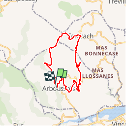
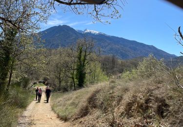
Tocht Stappen van 15 km beschikbaar op Occitanië, Pyrénées-Orientales, Arboussols. Deze tocht wordt voorgesteld door jcmartin.
Beschrijving
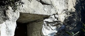
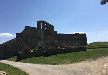
Circuit au départ d'Arboussols. Sur le parking un plan indique toutes les randonnées possibles (circuits bien balisés. Le circuit que j'ai fait est une combinaison de plusieurs circuits, attention la partie entre le col de Guès et Tarerach est hors circuit et n'est pas balisée. La grotte (point 8) ou chambre des certitudes est en option et est fermée à clef, on peut la visiter en appelant le 00 33 6 15 13 16 12
Plaatsbepaling
Opmerkingen
Wandeltochten in de omgeving
![Tocht Mountainbike Vinça - parcours ronde de Sahorle 2013 - Photo](https://media.geolcdn.com/t/375/260/ext.jpg?maxdim=2&url=https%3A%2F%2Fstatic1.geolcdn.com%2Fsiteimages%2Fupload%2Ffiles%2F1524743154velo.jpg)
![Mountainbike Mountainbike](https://static1.geolcdn.com/sitytour/trail-icons/202.png)
Mountainbike
![](/images/other/stat-length.png)
![](https://static1.geolcdn.com/siteimages/upload/files/16400158638029165_repeat_loop_refresh_sync_direction_icon.png)
![Tocht Stappen Marquixanes - marquixanes - Photo](https://media.geolcdn.com/t/375/260/9f15ae53-8545-42f8-abb5-8d004f9aced2.jpg&format=jpg&maxdim=2)
![Stappen Stappen](https://static1.geolcdn.com/sitytour/trail-icons/101.png)
Stappen
![](/images/other/stat-length.png)
![](https://static1.geolcdn.com/siteimages/upload/files/16400158638029165_repeat_loop_refresh_sync_direction_icon.png)
![Tocht Stappen Trévillach - Séquière depuis le col des Auzines - Photo](https://media.geolcdn.com/t/375/260/39e63d62-b4cc-4561-86e2-4b8e2910e465.jpg&format=jpg&maxdim=2)
![Stappen Stappen](https://static1.geolcdn.com/sitytour/trail-icons/101.png)
Stappen
![](/images/other/stat-length.png)
![](https://static1.geolcdn.com/siteimages/upload/files/16400158638029165_repeat_loop_refresh_sync_direction_icon.png)
![Tocht Stappen Arboussols - Marcevol - Photo](https://media.geolcdn.com/t/375/260/c36f51d8-a44d-419f-a023-7a6ff9003ad5.jpg&format=jpg&maxdim=2)
![Stappen Stappen](https://static1.geolcdn.com/sitytour/trail-icons/101.png)
Stappen
![](/images/other/stat-length.png)
![](https://static1.geolcdn.com/siteimages/upload/files/16400158638029165_repeat_loop_refresh_sync_direction_icon.png)
![Tocht Stappen Tarerach - Tarerach - Photo](https://media.geolcdn.com/t/375/260/ac55caa1-a948-4bf7-87aa-6f2d79de33ca.jpg&format=jpg&maxdim=2)
![Stappen Stappen](https://static1.geolcdn.com/sitytour/trail-icons/101.png)
Stappen
![](/images/other/stat-length.png)
![](https://static1.geolcdn.com/siteimages/upload/files/16400158638029165_repeat_loop_refresh_sync_direction_icon.png)
![Tocht Stappen Catllar - cap Béarn depuis port vendres - Photo](https://media.geolcdn.com/t/375/260/1195a2cb-99d5-4e1b-bb14-6566bf3b4c2e.jpg&format=jpg&maxdim=2)
![Stappen Stappen](https://static1.geolcdn.com/sitytour/trail-icons/101.png)
Stappen
![](/images/other/stat-length.png)
![](https://static1.geolcdn.com/siteimages/upload/files/16400158638029165_repeat_loop_refresh_sync_direction_icon.png)
![Tocht Stappen Los Masos - Los Masos Lionat - Photo](https://media.geolcdn.com/t/375/260/125a95df-244e-4de4-8ca5-3e656269ddeb.jpg&format=jpg&maxdim=2)
![Stappen Stappen](https://static1.geolcdn.com/sitytour/trail-icons/101.png)
Stappen
![](/images/other/stat-length.png)
![](https://static1.geolcdn.com/siteimages/upload/files/16400158638029165_repeat_loop_refresh_sync_direction_icon.png)
![Tocht Stappen Eus - 20210407 boucle au dessus d’Eus - Photo](https://media.geolcdn.com/t/375/260/6604aead-dc18-419e-be80-d3204e1caff4.jpg&format=jpg&maxdim=2)
![Stappen Stappen](https://static1.geolcdn.com/sitytour/trail-icons/101.png)
Stappen
![](/images/other/stat-length.png)
![](https://static1.geolcdn.com/siteimages/upload/files/16400158638029165_repeat_loop_refresh_sync_direction_icon.png)
![Tocht Stappen Arboussols - Arboussols - Marcevol - Photo](https://media.geolcdn.com/t/375/260/b35773f8-cc62-4064-9d4f-176d831816d7.jpg&format=jpg&maxdim=2)
![Stappen Stappen](https://static1.geolcdn.com/sitytour/trail-icons/101.png)
Stappen
![](/images/other/stat-length.png)
![](https://static1.geolcdn.com/siteimages/upload/files/16400158638029165_repeat_loop_refresh_sync_direction_icon.png)