![](/images/other/stat-length.png)
![Tocht Stappen Vatilieu - Le Tour de Vatilleu par les sculptures aux quatre vents2011-06-26 16h59m34 - Photo](https://media.geolcdn.com/t/1900/400/ext.pjpeg?maxdim=2&url=https%3A%2F%2Fstatic1.geolcdn.com%2Fsiteimages%2Fupload%2Ffiles%2F1553511878bg_sport_marche.png)
Le Tour de Vatilleu par les sculptures aux quatre vents2011-06-26 16h59m34
psesjs
Gebruiker
![Lengte](/images/other/stat-length.png)
Lengte
11,3 km
![Max. hoogte](https://static1.geolcdn.com/siteimages/upload/files/1508320355ic_sort_altitude_max_24dp.png)
Max. hoogte
780 m
![Positief hoogteverschil](https://static1.geolcdn.com/siteimages/upload/files/1508320355ic_sort_den_pos_24dp.png)
Positief hoogteverschil
443 m
![Km-Effort](/images/other/stat-length.png)
Km-Effort
17,2 km
![Min. hoogte](https://static1.geolcdn.com/siteimages/upload/files/1508320355ic_sort_altitude_min_24dp.png)
Min. hoogte
444 m
![Negatief hoogteverschil](https://static1.geolcdn.com/siteimages/upload/files/1508320355ic_sort_den_neg_24dp.png)
Negatief hoogteverschil
446 m
![Boucle](https://static1.geolcdn.com/siteimages/upload/files/16400158638029165_repeat_loop_refresh_sync_direction_icon.png)
Boucle
Ja
Datum van aanmaak :
2014-12-10 00:00:00.0
Laatste wijziging :
2014-12-10 00:00:00.0
![Stappen](https://static1.geolcdn.com/sitytour/trail-icons/101.png)
--
Moeilijkheid : Gemakkelijk
![Scan deze QR-code om de tocht te openen in de SityTrail-applicatie](https://capi.geolives.com/qq0zvz2zws4bq2lad0pu/sitytour/trails/68209/qr.png?size=200)
Gratisgps-wandelapplicatie
Over ons
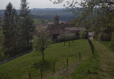
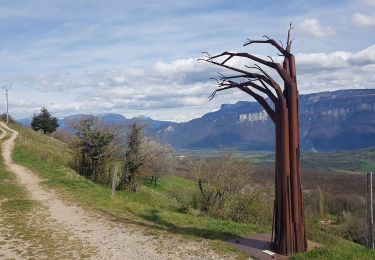
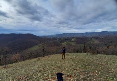
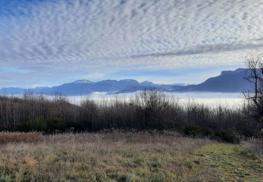
Tocht Stappen van 11,3 km beschikbaar op Auvergne-Rhône-Alpes, Isère, Vatilieu. Deze tocht wordt voorgesteld door psesjs.
Beschrijving
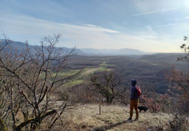
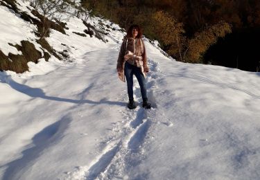
Très belle randonnée pour découvrir les sculptures aux quatre vents. Un très beau panorama sur le Vercors et les coteaux de Vatilleu...
Plaatsbepaling
Land:
France
Regio :
Auvergne-Rhône-Alpes
Departement/Provincie :
Isère
Gemeente :
Vatilieu
Locatie:
Unknown
Vertrek:(Dec)
Vertrek:(UTM)
688962 ; 5014243 (31T) N.
Opmerkingen
Wandeltochten in de omgeving
![Tocht Stappen Vatilieu - 38 vatilieu - Photo](https://media.geolcdn.com/t/375/260/b269b01e-8989-441e-b082-d3b28704dde9.jpg&format=jpg&maxdim=2)
![Stappen Stappen](https://static1.geolcdn.com/sitytour/trail-icons/101.png)
38 vatilieu
Stappen
Gemakkelijk
Vatilieu,
Auvergne-Rhône-Alpes,
Isère,
France
![](/images/other/stat-length.png)
11,4 km | 17,4 km-effort
6h 22min
![](https://static1.geolcdn.com/siteimages/upload/files/16400158638029165_repeat_loop_refresh_sync_direction_icon.png)
Ja
![Tocht Stappen La Forteresse - Croix de Baron - Photo](https://media.geolcdn.com/t/375/260/ext.jpg?maxdim=2&url=https%3A%2F%2Fstatic1.geolcdn.com%2Fsiteimages%2Fupload%2Ffiles%2F1553511878bg_sport_marche.png)
![Stappen Stappen](https://static1.geolcdn.com/sitytour/trail-icons/101.png)
Croix de Baron
Stappen
Medium
(2)
La Forteresse,
Auvergne-Rhône-Alpes,
Isère,
France
![](/images/other/stat-length.png)
9,6 km | 13,2 km-effort
3h 15min
![](https://static1.geolcdn.com/siteimages/upload/files/16400158638029165_repeat_loop_refresh_sync_direction_icon.png)
Ja
![Tocht Stappen Vatilieu - Les Crêtes de Vatilieu - Photo](https://media.geolcdn.com/t/375/260/2a3eeb1a-222b-49d5-98c3-83171aaed5b5.jpg&format=jpg&maxdim=2)
![Stappen Stappen](https://static1.geolcdn.com/sitytour/trail-icons/101.png)
Les Crêtes de Vatilieu
Stappen
Medium
Vatilieu,
Auvergne-Rhône-Alpes,
Isère,
France
![](/images/other/stat-length.png)
11,5 km | 17,6 km-effort
3h 31min
![](https://static1.geolcdn.com/siteimages/upload/files/16400158638029165_repeat_loop_refresh_sync_direction_icon.png)
Ja
![Tocht Stappen Serre-Nerpol - Crêtes de Senepol- La Routière - Photo](https://media.geolcdn.com/t/375/260/3ca501d9-5e9d-4131-9d18-b4898610f954.jpg&format=jpg&maxdim=2)
![Stappen Stappen](https://static1.geolcdn.com/sitytour/trail-icons/101.png)
Crêtes de Senepol- La Routière
Stappen
Gemakkelijk
(2)
Serre-Nerpol,
Auvergne-Rhône-Alpes,
Isère,
France
![](/images/other/stat-length.png)
5,4 km | 8,2 km-effort
1h 18min
![](https://static1.geolcdn.com/siteimages/upload/files/16400158638029165_repeat_loop_refresh_sync_direction_icon.png)
Ja
![Tocht Stappen Chantesse - Traversée Chantesse Vitalieu Vinay - Photo](https://media.geolcdn.com/t/375/260/fcb44952-9760-427c-a2ff-8d11a64ffce4.jpg&format=jpg&maxdim=2)
![Stappen Stappen](https://static1.geolcdn.com/sitytour/trail-icons/101.png)
Traversée Chantesse Vitalieu Vinay
Stappen
Moeilijk
Chantesse,
Auvergne-Rhône-Alpes,
Isère,
France
![](/images/other/stat-length.png)
17,7 km | 25 km-effort
6h 22min
![](https://static1.geolcdn.com/siteimages/upload/files/16400158638029165_repeat_loop_refresh_sync_direction_icon.png)
Neen
![Tocht Stappen Varacieux - Le Molard d'Essemat- Varacieux - Photo](https://media.geolcdn.com/t/375/260/a5d0403b-ce12-4804-bf0d-c01332f8e7cc.jpg&format=jpg&maxdim=2)
![Stappen Stappen](https://static1.geolcdn.com/sitytour/trail-icons/101.png)
Le Molard d'Essemat- Varacieux
Stappen
Medium
Varacieux,
Auvergne-Rhône-Alpes,
Isère,
France
![](/images/other/stat-length.png)
5,1 km | 7,5 km-effort
2h 11min
![](https://static1.geolcdn.com/siteimages/upload/files/16400158638029165_repeat_loop_refresh_sync_direction_icon.png)
Ja
![Tocht Stappen Serre-Nerpol - toutes aures - Photo](https://media.geolcdn.com/t/375/260/5607a9f7-aea0-49ba-a095-ec1e7b75f166.jpg&format=jpg&maxdim=2)
![Stappen Stappen](https://static1.geolcdn.com/sitytour/trail-icons/101.png)
toutes aures
Stappen
Gemakkelijk
Serre-Nerpol,
Auvergne-Rhône-Alpes,
Isère,
France
![](/images/other/stat-length.png)
4 km | 6,5 km-effort
2h 5min
![](https://static1.geolcdn.com/siteimages/upload/files/16400158638029165_repeat_loop_refresh_sync_direction_icon.png)
Neen
![Tocht Mountainbike L'Albenc - autour de l'albenc - vtt - episode 1 - Photo](https://media.geolcdn.com/t/375/260/ext.jpg?maxdim=2&url=https%3A%2F%2Fservices.sitytrail.com%2FGeolivesWS%2FDownloadMedia.ashx%3FTrailID%3D1058080%26Media%3Dfix__20181017145623.jpg)
![Mountainbike Mountainbike](https://static1.geolcdn.com/sitytour/trail-icons/202.png)
autour de l'albenc - vtt - episode 1
Mountainbike
Gemakkelijk
L'Albenc,
Auvergne-Rhône-Alpes,
Isère,
France
![](/images/other/stat-length.png)
10,5 km | 14,7 km-effort
56min
![](https://static1.geolcdn.com/siteimages/upload/files/16400158638029165_repeat_loop_refresh_sync_direction_icon.png)
Ja
![Tocht Stappen Vinay - Rando patrimoine du 14 novembre 2024 - Photo](https://media.geolcdn.com/t/375/260/88c10101-3c0b-4a60-8e48-cbffea749ad1.jpg&format=jpg&maxdim=2)
![Stappen Stappen](https://static1.geolcdn.com/sitytour/trail-icons/101.png)
Rando patrimoine du 14 novembre 2024
Stappen
Moeilijk
Vinay,
Auvergne-Rhône-Alpes,
Isère,
France
![](/images/other/stat-length.png)
8,8 km | 12,2 km-effort
2h 46min
![](https://static1.geolcdn.com/siteimages/upload/files/16400158638029165_repeat_loop_refresh_sync_direction_icon.png)
Ja