![](/images/other/stat-length.png)
![Tocht Stappen Lamalou-les-Bains - GR7 E20 Lamalou-Douch - Photo](https://media.geolcdn.com/t/1900/400/ext.pjpeg?maxdim=2&url=https%3A%2F%2Fstatic1.geolcdn.com%2Fsiteimages%2Fupload%2Ffiles%2F1553511878bg_sport_marche.png)
GR7 E20 Lamalou-Douch
richard21220
Gebruiker
![Lengte](/images/other/stat-length.png)
Lengte
15,8 km
![Max. hoogte](https://static1.geolcdn.com/siteimages/upload/files/1508320355ic_sort_altitude_max_24dp.png)
Max. hoogte
1067 m
![Positief hoogteverschil](https://static1.geolcdn.com/siteimages/upload/files/1508320355ic_sort_den_pos_24dp.png)
Positief hoogteverschil
1066 m
![Km-Effort](/images/other/stat-length.png)
Km-Effort
28 km
![Min. hoogte](https://static1.geolcdn.com/siteimages/upload/files/1508320355ic_sort_altitude_min_24dp.png)
Min. hoogte
190 m
![Negatief hoogteverschil](https://static1.geolcdn.com/siteimages/upload/files/1508320355ic_sort_den_neg_24dp.png)
Negatief hoogteverschil
352 m
![Boucle](https://static1.geolcdn.com/siteimages/upload/files/16400158638029165_repeat_loop_refresh_sync_direction_icon.png)
Boucle
Neen
Datum van aanmaak :
2017-03-10 00:00:00.0
Laatste wijziging :
2017-03-10 00:00:00.0
![Stappen](https://static1.geolcdn.com/sitytour/trail-icons/101.png)
6h01
Moeilijkheid : Gemakkelijk
![Scan deze QR-code om de tocht te openen in de SityTrail-applicatie](https://capi.geolives.com/qq0zvz2zws4bq2lad0pu/sitytour/trails/680943/qr.png?size=200)
Gratisgps-wandelapplicatie
Over ons
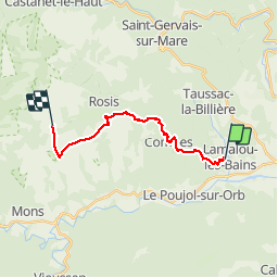
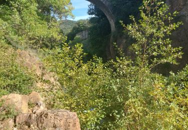
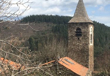
Tocht Stappen van 15,8 km beschikbaar op Occitanië, Hérault, Lamalou-les-Bains. Deze tocht wordt voorgesteld door richard21220.
Beschrijving
Refuge Marcel Cèbe : Douch 34610 ROSIS Tél 04 67 95 21 41 ou 04 67 23 60 73
Gîte Communal : Douch 34610 ROSIS Tél 04 67 23 60 73
Plaatsbepaling
Land:
France
Regio :
Occitanië
Departement/Provincie :
Hérault
Gemeente :
Lamalou-les-Bains
Locatie:
Unknown
Vertrek:(Dec)
Vertrek:(UTM)
506592 ; 4826944 (31T) N.
Opmerkingen
Wandeltochten in de omgeving
![Tocht Stappen Hérépian - herepian pic de Tantajo - Photo](https://media.geolcdn.com/t/375/260/ext.jpg?maxdim=2&url=https%3A%2F%2Fservices.sitytrail.com%2FGeolivesWS%2FDownloadMedia.ashx%3FTrailID%3D656804%26Media%3D20161106140841.jpg)
![Stappen Stappen](https://static1.geolcdn.com/sitytour/trail-icons/101.png)
herepian pic de Tantajo
Stappen
Gemakkelijk
(1)
Hérépian,
Occitanië,
Hérault,
France
![](/images/other/stat-length.png)
13 km | 18,6 km-effort
4h 17min
![](https://static1.geolcdn.com/siteimages/upload/files/16400158638029165_repeat_loop_refresh_sync_direction_icon.png)
Ja
![Tocht Fiets Villemagne-l'Argentière - bedarieux. Mons la trivale par la voie verte allé retour - Photo](https://media.geolcdn.com/t/375/260/ext.jpg?maxdim=2&url=https%3A%2F%2Fservices.sitytrail.com%2FGeolivesWS%2FDownloadMedia.ashx%3FTrailID%3D217102%26Media%3D20130827171314.jpg)
![Fiets Fiets](https://static1.geolcdn.com/sitytour/trail-icons/200.png)
bedarieux. Mons la trivale par la voie verte allé retour
Fiets
Heel gemakkelijk
(2)
Villemagne-l'Argentière,
Occitanië,
Hérault,
France
![](/images/other/stat-length.png)
31 km | 37 km-effort
3h 11min
![](https://static1.geolcdn.com/siteimages/upload/files/16400158638029165_repeat_loop_refresh_sync_direction_icon.png)
Neen
![Tocht Stappen Taussac-la-Billière - orgues de taussac - Photo](https://media.geolcdn.com/t/375/260/ext.jpg?maxdim=2&url=https%3A%2F%2Fservices.sitytrail.com%2FGeolivesWS%2FDownloadMedia.ashx%3FTrailID%3D145474%26Media%3D20120811112610.jpeg)
![Stappen Stappen](https://static1.geolcdn.com/sitytour/trail-icons/101.png)
orgues de taussac
Stappen
Gemakkelijk
(2)
Taussac-la-Billière,
Occitanië,
Hérault,
France
![](/images/other/stat-length.png)
9,3 km | 14,2 km-effort
3h 1min
![](https://static1.geolcdn.com/siteimages/upload/files/16400158638029165_repeat_loop_refresh_sync_direction_icon.png)
Ja
![Tocht Stappen Les Aires - Saint Michel la coquillade - Photo](https://media.geolcdn.com/t/375/260/ext.jpg?maxdim=2&url=https%3A%2F%2Fservices.sitytrail.com%2FGeolivesWS%2FDownloadMedia.ashx%3FTrailID%3D419022%26Media%3Dfix__20150406153326.jpg)
![Stappen Stappen](https://static1.geolcdn.com/sitytour/trail-icons/101.png)
Saint Michel la coquillade
Stappen
Medium
(1)
Les Aires,
Occitanië,
Hérault,
France
![](/images/other/stat-length.png)
13,2 km | 21 km-effort
4h 7min
![](https://static1.geolcdn.com/siteimages/upload/files/16400158638029165_repeat_loop_refresh_sync_direction_icon.png)
Ja
![Tocht Te voet Les Aires - Pic de la Coquillade - Photo](https://media.geolcdn.com/t/375/260/a1b049b6-4309-4e8c-86c9-1d2c07783337.jpeg&format=jpg&maxdim=2)
![Te voet Te voet](https://static1.geolcdn.com/sitytour/trail-icons/100.png)
Pic de la Coquillade
Te voet
Gemakkelijk
Les Aires,
Occitanië,
Hérault,
France
![](/images/other/stat-length.png)
11,3 km | 19 km-effort
4h 19min
![](https://static1.geolcdn.com/siteimages/upload/files/16400158638029165_repeat_loop_refresh_sync_direction_icon.png)
Ja
![Tocht Stappen Hérépian - vallée des arômes - Photo](https://media.geolcdn.com/t/375/260/c6753d91-15fa-4844-b595-c6b7592a45cf.jpg&format=jpg&maxdim=2)
![Stappen Stappen](https://static1.geolcdn.com/sitytour/trail-icons/101.png)
vallée des arômes
Stappen
Medium
Hérépian,
Occitanië,
Hérault,
France
![](/images/other/stat-length.png)
13,4 km | 17,4 km-effort
3h 11min
![](https://static1.geolcdn.com/siteimages/upload/files/16400158638029165_repeat_loop_refresh_sync_direction_icon.png)
Ja
![Tocht Stappen Le Poujol-sur-Orb - Rando Seviracttt - Photo](https://media.geolcdn.com/t/375/260/abbb6ad5-7718-434b-be19-2e67e5d9637f.jpg&format=jpg&maxdim=2)
![Stappen Stappen](https://static1.geolcdn.com/sitytour/trail-icons/101.png)
Rando Seviracttt
Stappen
Zeer moeilijk
Le Poujol-sur-Orb,
Occitanië,
Hérault,
France
![](/images/other/stat-length.png)
14,9 km | 21 km-effort
4h 40min
![](https://static1.geolcdn.com/siteimages/upload/files/16400158638029165_repeat_loop_refresh_sync_direction_icon.png)
Ja
![Tocht Stappen Villemagne-l'Argentière - Boussagues - Photo](https://media.geolcdn.com/t/375/260/be08c2e4-1762-4385-aef6-316aec3868b5.jpg&format=jpg&maxdim=2)
![Stappen Stappen](https://static1.geolcdn.com/sitytour/trail-icons/101.png)
Boussagues
Stappen
Medium
Villemagne-l'Argentière,
Occitanië,
Hérault,
France
![](/images/other/stat-length.png)
16 km | 22 km-effort
4h 30min
![](https://static1.geolcdn.com/siteimages/upload/files/16400158638029165_repeat_loop_refresh_sync_direction_icon.png)
Ja
![Tocht Stappen Combes - Le Fraïsse (Villecelle) - Col des Princes - Saint-Vital - Combes - Torteillan - Photo](https://media.geolcdn.com/t/375/260/2abe5219-7c42-4fb2-835f-54e3fc346f74.jpg&format=jpg&maxdim=2)
![Stappen Stappen](https://static1.geolcdn.com/sitytour/trail-icons/101.png)
Le Fraïsse (Villecelle) - Col des Princes - Saint-Vital - Combes - Torteillan
Stappen
Moeilijk
(1)
Combes,
Occitanië,
Hérault,
France
![](/images/other/stat-length.png)
13,5 km | 20 km-effort
4h 25min
![](https://static1.geolcdn.com/siteimages/upload/files/16400158638029165_repeat_loop_refresh_sync_direction_icon.png)
Ja